Virginia Blues
¤
Where monotony is found a harsher
foe than granite
Burkes Garden VA to Pearisburg, VA
A full 1/4 of the entire AT lies within Virginia, its 541 miles roughly following the lengthy
diagonal border to the west. Here the AT proves a war of attrition; and by its end at Harper's
Ferry, a full half the hikers' dreams of Mt Katahdin will have been dashed.
Spring is considerably delayed this year, snow and ice storms still sweeping across our undone
northern sections, so we're obliged to return to the south for a short section. Having left off at
Burkes Garden, we'll hike northbound from there this time - at least we can now get there without
placing our shuttle driver in mortal peril. But before returning to our car, we'll know the real
face of the challenge offered by the Virginia Highlands.
|
3/9 Garden Mt- VA 615 campsite (8.8 miles)
"Indian builds little fire - sits close
white man builds big fire - sits far away"
Boy Scout adage
Our shuttle is arranged with Mickey & Diane, proprietors of a small B & B / bookstore in
Pearisburg, and pulling up to the our planned rendezvous at the Rendezvous Motel, we see the
expected red van waiting there. Mickey takes us a bit by surprise - he's a good ol' boy who seems
quite at home here in Appalachia. We rattle our way up the familiar 623 to the trailhead, saying
our goodbyes and beginning our hike at a late 1: 42, stopping at the first overlook to finally see
"God's Thumbprint", which we'd been denied by weather on our last section (it'd be a bit more
stunning with good weather and green fields). Walking the ridgeline we're treated to a few deer and
numerous grouse, the blustery wind up here giving us the familiar "singing trees" - creaking with
all manner of animal sounds as they blow across each other. We take a quick pm break at Jenkins
Shelter, continuing down a forest road and through a series of campsites before making a quick hop
over Brushy Mt.
|
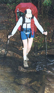 |
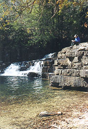
| One of a dozen crossings of Laurel Creek
|
Approaching Little Wolf Creek is a high water bypass that we shouldn't need (although in prophetic
fashion, the rain starts as soon as we pass it). We'll cross the creek 12 times over the next 2
miles, with the first couple easy enough, though the creek grows progressively wider as we head
downstream, with greater spaces between the scattered rocks. We make it through without having to
ford though, our trial by water ending with a trip across Laurel Creek on a narrow bridge - so
narrow in fact that our packs won't fit across without turning sideways. Here we cross VA 615,
where the trail starts uphill through a series of campgrounds, stopping on one of the picnic tables
here to assess our navigation. We'd planned to continue a few more miles tonight, but this site is
too good to pass up, and with the speed we're making today, a 19 mile day to the shelter tomorrow
should be a piece of cake. Besides, it'll be far calmer down here, and the wind's already rising on
the ridgeline; plus we have a picnic table here - the lap of luxury. So, at an "early" 6:00 we set
up camp, with plenty of wood around for a fire and the creek adjacent for water, having our
sandwiches for dinner. As we're sitting around our "white-man's fire" reflecting, I dry out boots
by the fire, although as we're making our hot drinks for the evening, Coleen adds a huge pile of
wood as I'm heating the water. As the water nears the boiling point, I notice that it's melting our
homemade pot stand; and as I take off the pot to save it, I turn around to find one of my boots
burning in front of the surging fire. We knew we'd need a better pot support - now it looks like
new boots as well; and we turn in to our cozy tent nestled in the pines at an early 2110.
3/10 VA 615 - Jenny Knob Shelter (19.0 miles)
"Are they as straw before the
wind,
And like chaff, which the storm carries away?".
Bible - Job 21:18
There is but one word for today's hike - WINDY!!!. It all began last night about an
hour after we retired, only to be awakened by a mighty roar and the feeling of my Thermarest being
lifted off the ground. We wake to find the wind trying its best to turn over our tent, in spite of
our weight and sheltered location. After a bit it calms down and we're able to get back to sleep,
but not before I have go out to find all the clothes we'd had hanging out to dry. This morning it
roars through the campsite, but our coffee wards off the blustery 26F temp (with ice in all our
outside water). As we start hiking, the fierce wind of the valleys intensifies to gale force on the
ridges - the sheltered south faces of the ridge are calm and warm, but the north face of Brushy Mt
is brutally cold, and we can't wait for the descent. Luckily the trail winds around the contours of
the slope, alternating between short legs in the sun, and much longer legs on the frigid north face,
but the former can't begin to equal the latter. Finally we come to US 21/52, where the Mt Hope
Holiness Church looks so inviting that we almost stop in to warm up (after all, what evangelical
church doesn't have a coffee pot somewhere on Sun morning?).
| 
|
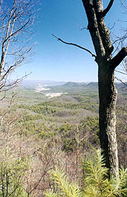
Brushy Mt Overlook
| We push on to the I-77 crossing though, the
wind blowing us down the hill to the bridge. It's quite an exercise getting across the overpass
without losing anything to the wind, but once across, the trail descends into a far calmer woods
around Kimberling Creek. We're ready for a break down here out of the wind, but decide instead to
push on to Helveys Mill shelter - just on a mile further. It's a steady but easy climb up, and on
arrival there we find the shelter's .3 miles off the trail, so we take our break on a log here at
the trail, on the sheltered and sunny south face. From here it's an uneventful ridge walk, with a
pm break / lunch at a sheltered location, continuing on towards Jenny Knob shelter.
|
|
We come across the shelter trail at 4:00, and though I'm seriously considering going further, Coleen
is ready to stop now, her feet hurting badly. It's amazing - in spite of our 19-mile day, we're
here hours before sunset - this section's just too easy. She heads down to the spring for water - a
long way, but not as bad as advertised, and I canvass the area for the sparse firewood supply. The
sun slowly retreats over the ridge just ahead of the shelter, and we have to put on our sunglasses
as we prepare dinner. It's a beautiful evening, and as darkness falls and the wind declines, I
start the fire, even though we'll watch it from within the warmer shelter. We have a good chance to
read through the register, and I even do a crossword as Coleen searches the radio for weather and
news. Soon it's time for hot drinks and dessert, listening to an owl and watching the vibrant
stars; turning in at an incredible 9:06.
|
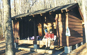
| Setting up camp in the sun for a change
|
3/11 Jenny Knob - Sugar Run tent site (19.8 miles)
"It's life, Jim... but not as we know it"
Leonard "Bones" McCoy - Star Trek (Gene Rodenberry)
|
| It's a good night for sleeping, waking at 6:20
to a beautiful calm clear morning; and after coffee and breakfast we're able to get an early start.
Today's first goal is VA 606, where we hope to catch a town meal and check the answering machine.
It's an easy climb over the spine of Brushy Mt, cruising the ridge until the desc into 606, preceded
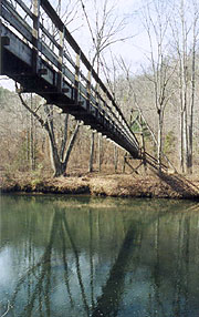
by Kimberling Creek once again. It's spanned by a beautiful suspension bridge, and on the opposite
side we hide our packs for the walk to Tony's Deli. It's alleged to be .8 miles, but it's only
about .3, a mini-mart situated just across from a logging camp (now Trent's Grocery) ; and filled
with the clientele one would expect. They all ask how our hike's going, and as we sit to have our
meal, a story is passed along behind us that's emblematic of the region (names changed to protect
the innocent)
"Billy Jim Bob drove that nail right through his fanger, so hard he couldn't get it out".
"What'd he do then"?
"He had to saw off the board and go to sleep with it still nailed to his fanger".
"Bet he didn't get much sleep that night".
|
|
| Bridge over Kimberling Creek
|
We listened to such entertainment over a couple slices of pizza, Dorito's and a 2L bottle of DC, and
finally had to finish up with our bathroom chores and phone messages, and get back underfoot. We're
back at the trail at 11:34, bound for our next entertainment - Dismal Creek Falls. As the trail
winds up the mountainside, we can hear the falls below, and for a while it seems we're going away
from them, but finally we come to the old sign showing .2 miles to the falls. We leave our packs
here and head down, finding this .2 far longer than the .8 to Tony's. it's worth every foot though,
as the falls are gorgeous, surrounded by a hemlock grove, and would be an excellent place for a dip
in the summer. After consuming the last of the film on my camera, I finally run back to our packs
for more as Coleen rests here, and on my return we have yet another photo session.
|
It's 1:34 when we return to the trail, having decided that our night's destination is to be the
Honey Spring Picnic area, a small clearing with a picnic table and a spring-fed pond atop Sugar Run
Mt - our only hope is that the road isn't too traveled, in hopes of a quiet night here. It's a
beautiful hike up Dismal Creek - nothing dismal here - full of rhododendron and pine, and all the
crossings provided with adequate bridges. We take a break at Wapiti Shelter Wapiti (Indian for
Standing Elk - a population of 78 of which were once counted in the area, but have all died off
now), just preceded by a beautiful pond that would make an excellent campsite had we not wanted to
press on further.
We know the climb ahead is to be steep, but we're not quite prepared for all the rocks and the
stiffening west wind which hits us as we round the south side of the mountain. It chills our sweaty
bodies quickly as we level off on the top, and the clouds that now cover the sun cool and darken the
landscape as well. I'd love to stop and put on my jacket, but we're expecting to hit the picnic
area any minute, little knowing how much the rocky climb has slowed our pace. We wind around the
mountain, the radio tower atop in sight, and finally we come to the road down to the picnic area.
It's only .1 mile but it seems further going straight in to the stiff winds, now directly in our
face. When we arrive, we find we've been snookered big time - yes, there's a rickety picnic table,
but it's next to an abandoned shack, now full of trash, strewn around from the many parties held
here. The wind roars through the clearing, the pond is long-since dry; and it doesn't take long to
decide the lee side of the mountain will be a far better choice. We do find the spring however,
filling a couple of our bottles there for water to boil, and load up to head back towards the radio
array.
| 
|
| Nothing "dismal" about Dismal Falls - would make a great
swimming hole in warm weather |
|
A quick search finds little of interest here either, and with dark falling and the wind rising (at
least I've got my jacket on now), we've got to look quickly. We wander around the roads up here for
a few minutes, finding little (all very rocky), and after a few minutes we find our way back to the
AT - a little more hidden than one would guess. There's an old coot driving by on the road, and
Coleen imagines he might offer us a stay (he doesn't), but soon we're back to hunting for a tent
site. There's a large pine stand just off the road, but the wind roars through it, and we quickly
decide we'd be better off on the lee side, returning to the AT northbound. Our progress is glacial
over the rocks at night, but finally the trail reveals a small level calm area free of rocks where
the tent can be pitched. Coleen's sold immediately, and we get the tent up and dinner started
promptly, eating by our headlamps on a log here, and turning in to bed at 10:00.
3/12 Sugar Run - Pearisburg (10 miles)
"The most beautiful
thing we can experience is the mysterious.
It is the source of all art and science."
Albert Einstein
Between my cough and the caffeine in yesterday's DC, sleep eludes me almost
completely, after midnight taking a couple lozenges with little success and only nodding off
fitfully in the wee hours. I wake at 5:00 to the sound of sleet on the tent, getting up for good an
hour later at the scant first light. Coleen's feeling the call of nature, and suggests we skip
breakfast until Doc's Knob shelter, hoping to find a privy as I make breakfast. This seems a good
idea as it's still raining outside, and we throw everything in the packs, getting underway at 6:50.
It's pretty wet out, and as we climb we find a light dusting of snow all around.
It seems an eternity to Doc's Knob, but finally we're there, finding someone's pushed the picnic
table over to become a needed step, and I start breakfast as Coleen runs for the privy. Soon we're
both satisfied (finding that Coleen left the windscreen to the stove behind), but I'm chilling
quickly, and anxious to get going. We return to the tedious trail, finally coming to the short,
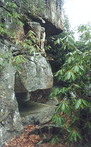
but very steep climb to the crest of Pearis Mt. There are numerous overlooks, but we're
still in and out of the cloud, so there's nothing to see (though we do take some pix), with our
descent starting from Angel's Rest. It'd be a beautiful view any other day, but other than the
monstrous rock ledges here there's little to see, so we head down steeply, the trail alternating
between rocks, frozen mud, and finally, unfrozen mud. Our boots like cement slippers, and would be
a real annoyance were we not already audibly close to our destination. We're still atop most of the
clouds and can hear Pearisburg below - an eerie feeling, but we're pushing on quickly towards the
car. Finally the descent lessens, and the buildings of town start to appear, finally including our
car. We arrive at 12:25, and after the customary end-of-section kiss, we roar off in the car in
search of chili, changing clothes in the car as we do. Guess we'd better get our
socially-acceptable personas back out.
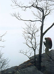
|
| Looking down on the clouds, the noises of
Pearisburg audible underneath
|
 |
| Angel's Rest signals our descent
|
|


