April allows another neatly-carved 4-day outing, and it seems a perfect time to finish nearby Shenandoah
National Park. Known for plentiful deer, bear, and other wildlife, it is also renowned for its wide and
well-graded treadway, and for the ample "town food" available every few miles. Oh well, two out of
three ain't really that bad.
|
4/7 Big Meadows - Bearfence Hut (7.1 miles)"'Tis the
best of humanity that comes out to walk"
Emerson
By the time we reach Rockfish Gap, Coleen's ready to swear off the self-shuttling process forever, a
result of me losing her three times in traffic - didn't really mean to, it's just that our decision not
to leave til after church has left us pretty tight on time. Leaving the Del Sol here, we head north in
the Eclipse to Swift Run Gap, filling out our backcountry permit and getting a few tips on water and a
small forest fire west of our planned overnight from one of the girls there. We pass a few deer as we
head north on Skyline, and soon we're at Big Meadows, where I check in with Ranger Rick inside.
|
Finding him clueless, we unload and head west in search of the A.T. at a late 5:05, although it proves
elusive, the inset map not matching the terrain well. We wind through the employee housing area,
finally connecting to the AT, where we march ahead at the typically easy Shenandoah pace. Passing Milan
Gap we find ourselves making an unprecedented 3 mph, blazing across Hazel Top Mt, passing many deer on
the way, along with several day hikers, and even one father whose son insisted on being brought here for
his 9th birthday (beats Chuck E Cheese's). We leave the side trail to the Bearfence Rock Scramble for
another day, with the descent leading to a small road that perfectly fits the map description of the
road into Bearfence Hut, our planned destination. Our guess is soon confirmed by the sight of a roaring
fire in front of the hut, with a fairly large crowd gathered about. A couple deer scurry away to allow
us entry, and we find 6 hikers here, a few of whom are tenting on the hill behind.
There's plenty of room in the hut, so we throw our gear in the middle, with a couple set up to the right
and two guys to the left (and the entire upper deck unused). We dive straight into our sandwiches as
everyone chats around the fire, one lady in particular monopolizing the entire conversation. She's
ostensibly hiking various historic trails here, taking a 3-week break from home-schooling her 3
prodigious kids, who allegedly can draw the map of the world with latitude / longitude accuracy.
Another girl comes down from the tent area, a former Peace Corps volunteer in Samoa, with a few
interesting stories from that time. As Coleen switches to her camp shoes, we find the hot spot on her
heel is now a burst blister, very tender with some blood soaked through her sock. We're offered a
Second Skin patch along with a large bandage, which takes care of it for the time being, and soon we
have our cocoa, with everyone turning in about 9:30, and ourselves bringing up the rear an hour later.
The snoring starts before we ever get to sleep, with the guys on either side of us trading off the
duties - there's always one of them snoring loudly, and neither of us gets to sleep until around 2:30,
despite earplugs.
|
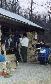 |
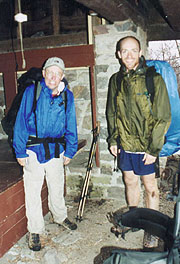
| Breakfast time at Bearfence Hut
|
4/8 Bearfence Hut - Pinefield Hut (20.6 miles)
"There's nothing like a good night's
sleep,
and that was nothing like a good night's sleep."
Bill Bryson - A Walk in the Woods
What's worse than finding yourself in a shelter full of snoring hikers? Finding out that
they're hiking to the same shelter as yourself the next day. Yep, after a woefully sleepless night
(Coleen says that when the snoring finally quieted, the mice came out), we find that the guys on the
left (Bob & Flyboy) are hiking together, bound for Pinefield Hut as ourselves today. They're good guys,
having met on the internet to hike together, but we decide from the outset that we'll probably tent
tonight outside tonight.
We're the first up, and though we're pretty quiet, everyone else is up and around soon thereafter. The
deer are wandering around the site as we depart, still a bit skittish to stick around for food. We're
underway by 7:30, Bob & Flyboy getting out a few minutes later, and we'll end up leapfrogging with them
the next couple days. We immediately come on the side trails to the Lewis Mt campground, and I head
through to survey the area as Coleen continues on the trail, lagging behind a bit with her aching heel.
The Coke machine is turned off, as is the water here; although I do find a working pay phone to check
our messages at home. By the time I rejoin Coleen she's been passed by both Bob & Flyboy, and after the
short climb over Baldface Mt we take our am break, then push on to Swift Run Gap, stopping at the Ranger
station for water. Bob's waiting with his and Flyboy's packs as Flyboy does the same, so we follow
suit. By the time we return to our packs, they've taken off, hiking the road in view of the many climbs
and descents on the profile view (the trail in Shenandoah roughly parallels Skyline Drive through the
park, and many hikers choose the latter as an easier "short cut" to the trail).
We're only a few minutes behind them, but our route is far more difficult, starting out with about a
1200' climb over Hightop Mt - an imposing-looking climb, even if we've done climbs far greater
previously (and it's warming enough now to make any climb a chore). We catch a quick lunch about 2/3 of
the way up before continuing the well-graded path, taking us dead over the summit as seems to be the
Shenandoah norm. After Powell Gap we take our pm break, with Coleen's heels hurting badly enough that
she wonders if she can even continue. I consider ditching her pack somewhere for a pickup on the
return, but make one last effort to convince her to try hiking without her new insoles. She's finally
willing to give it a try, taking these and the arch supports out, and we forge on through the climb and
back down to Simmons Gap. There's a ranger station 400 yards off the trail where we could fill our
water, but we decide it's too far, and continue our final climb over Weaver Mt, with Coleen staying up
with me for the first time in the hike. On asking, she reluctantly admits that her feet are fine for
the 1st time in the hike - I'm relieved just to know she can keep hiking.
|
Soon we're at Pinefield Hut - a nice hut, similar to Bearfence, and lying just across a clear-running
stream. Bob & Flyboy have been here just long enough for dinner, and with plenty of daylight left, we
chat for a while with Flyboy as we start our own. He's ex-Air Force, having hooked up with Bob via the
AT list, and familiar with our Patriot Express flights (though he's never taken any himself). Though
there's not much firewood around, I decide to burn the mound of trash left in the fire pit; and as I do,
I throw a few sticks and twigs in. Soon I've got a respectable fire, with the guys quickly joining the
charge to find wood. Soon we've a huge stack, and Bob's goal seems to be to consume it as soon as
possible, in spite of our chiding him about global warming and such. As the guys start to bed down, we
announce our intent to sleep out under the stars (something we haven't done before), dragging our bags
and tents up the hill to the tent sites. We lay our tent down to sleep upon the most level site, and
using the rain fly as a covering for Coleen, but it's still a bit sloped, and too short to adjust our
angle much. We select a compromise position and turn in at 9:55, although sleep eludes me for some
time.
| 
|
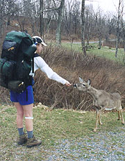
Does Bambi like Triscuits?
|
4/9 Pinefield Hut - Goat Ridge tentsite (21.3 miles)
All
that glitters is not gold;
All who wander are not lost."
JRR Tolkien - 'Lord of the Rings'
The "sleeping under the stars" allusion proves a misnomer, as we spend much of the night bereft of
either sleep or stars. Luckily, the gathering clouds don't yield any rain, and we're actually both
asleep in the wee small hours when some animal rouses us pawing around our site (never see him, but it's
probably a deer). We're up for good at 6:47, taking the tent down to the shelter with everything
wrapped in it, so we can pack as the coffee boils. The boys get up just behind us, and by 7:55 we're
out, the guys close on our tail. We start with a couple ups and downs as we approach Loft Mt., deciding
here to take a side trip at the Ivy Creek trail in hopes of finding a phone at the Loft Mt. Wayside. As
expected, the Wayside's not open yet, but we find some workers getting it so, and though there's no pay
phone here, there is a water tap. There's a Pepsi machine as well, but we're cool enough that it's not
very enticing, and we cross the road to meander through the Loft Mt. campground on our return to the AT,
still seeking a phone. At first we were afraid we'd be cheating ourselves out of a little elevation
gain on this route, but it quickly becomes obvious we'll go to the same summit as the AT, climbing
steadily on a paved walkway crowded with deer.
|
|
It feels odd walking through the deserted campground, and soon we're at the Camp Store, finding no phone
here, so we continue on towards another store marked on our map. We do find a locked restroom in the
picnic area, and decide to stop here for our break, with one deer sitting calmly a few yards away. In
spite of the numerous warning signs, we decide to try to get him to eat some Triscuits - takes some
doing on the 1st one, but after a sample, he's quickly back over for more. We meander about the
campground trying to return to the AT, finding our map horribly outdated, with little resemblance of the
surrounding area. Finally we accidentally stumble on a closed Ranger station with a phone, after which
we resume our search for the AT. We finally locate it, finding Bob sitting on a rock eating Gorp, with
Flyboy having pushed on ahead towards the Blackrock Hut, their planned overnight. They'd searched the
area in vain for a Coke machine - had I known we'd see them again, I'd have brought them one from the
Wayside.
|
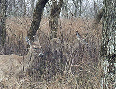
| Where's Bambi?
|
|
Descending to Brown's Gap, a light rain begins, soon continuing unabated, but it's not terribly hard,
and we push on without pack covers. We run into Flyboy just as we approach the summit of Blackrock Mt. -
he's coming back northbound, having elected to bypass the summit on a blue-blazed trail, but we stick
with the white blazes for the full treatment. It's a good call for each of us, as the summit is an
incredible rockpile worthy of several pictures - the well-groomed trail around it must have taken
incredible work to construct, and we reflect that were we anywhere but SNP, this would be a little slice
of hell. As we start down the descent, we see the hut in the hollow below, winding down its long side
trail.
By now the rain's falling heavily, and it's good to pull in under roof for a bit, finding Flyboy here
cooking lunch, and with Bob pulling in soon after. We take our late lunch here, finding from Bob that
his knee has given out, and he'll be pulling off the trail after leaving here. He's doing OK except for
downhills, and plans on taking the road out until he finds a ride, eschewing our offers of help. Flyboy
amuses us with a small explosion of his commercial alcohol stove, spewing flaming alcohol about, but by
some miracle his now-holey rain pants seem the only casualty. We're discussing how to get Bob out as a
northbounder comes in, telling of ample campsites but no water ahead, so we fill one water bottle with
spring water before shoving off.
Bob & Flyboy head out first, making a surprisingly good pace, and we're just behind, saying goodbye at
Blackrock Gap, where Bob takes to the road as Flyboy beats feet down the trail in hopes of making Calf
Mt tonight. We soon come on Arkansas Traveler - a Baptist minister from Knoxville who's come this far
from Springer over a 9-year period, and who openly asks about our Christianity. After passing the
Riprap trail the rain lets up, with a clear space and even a little sunlight appearing to the west.
Atop Wildcat Ridge we find plenty of good campsites, but it's early an we're still picky, hoping for one
on the sheltered east face of the mountain. At the end of the ridge the trail starts its descent around
to the east side, with a suitable clearing here that looks previously encamped, with several flat rocks
on which to sit. We set up camp, setting some clothes to dry, but soon the rain starts again, and
shortly after dinner it intensifies, forcing an early retreat to the crowded tent. We have our hot
drinks in this position, and finding ourselves somewhat trapped here, we both lie down and nod off in
spite of the rain pounding on the tent fabric. Finally at 11:00 we get up during a lull, getting out to
hang the bear bag before turning in for good.
|
|
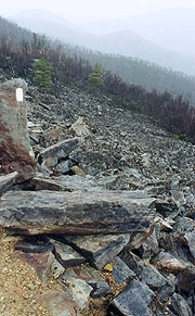
We're very thankful for a trail through this sea of
rocks
|
| Bob and Flyboy
| |
4/10 Goat Ridge - Rockfish Gap (11.9 miles)
"In Genesis, it says that it is not good for a man to be alone;
but sometimes it is a great
relief."
John Barrymore
We're up with first light, the wind now howling from the NW, and our tentsite
better shielded this morning (though it still lifts the tent edges occasionally). Being homecoming day,
we're easily motivated for the prep, though the howling wind and cool temps persuade Coleen to put on
everything imaginable before climbing out. The final clouds retreat to the east, and it looks like a
grand day out, though everything is still wet from last night. The last day's prep needn't be neat
though, and we're on the trail at 7:28, starting with the steep descent into Turk Gap, and thence on
towards Calf Mt shelter. The deer are out en masse again today, and the wind calms quickly as we
descend, passing the beautiful Moorman's River where our ascent begins up Calf Mt. Its pastoral mood is
marred by a spat we have here, Coleen wanting to stop to remove her jacket, but me wanting to wait until
the shelter, where we'll be stop to see if Flyboy's still around. My suggestion that I continue to the
shelter as she stops doesn't help the matter any.
She does so, taking an extended wardrobe rearrangement here, and as I continue, I run into Boone & CB, a
nice couple out to try the AT for a couple months, having begun yesterday from Rockfish Gap. They're
full of questions, and I'm all too happy to oblige, leaving Coleen a bit confused as she pulls up much
later to find us still chatting. We bid them a good hike and a few minutes later head down the shelter
trail - a long and rocky .3 off the trail. Flyboy's left some nice comments in the register about us
and his experience, but, we've miles to go, so it's back to the trail, now both bereft of our jackets
as we finish the climb over Calf Mt. The trail turns considerably more rocky now that we're out of
Shenandoah, though there are a number of beautiful alpine meadows and pine glades to traverse. From
Beagle Gap the trail marches straight up Bear Den Mt without switchbacks, but the scenery makes up for
the tough trail. There's a collection of communications towers atop the Mt, along with an odd
assortment of tractor seats overlooking Waynesboro.
|
From here we descend into McCormick Gap, with a short, but very steep climb out. It's all we'd expected
and more, and though I'm spent by the top, Coleen's lagging far worse. I yell to her that I'm at the
top, getting no response, and as I continue on the level segment, she lags further and further. I stop
several times and look back to check her progress, but the last time I look she's just standing there on
the trail, unmoving. I decide to forge ahead, with a bit more rocky trail before it finally connects
with a forest service road for a while. It's here that I hear a commotion to the right, looking
downslope to see a pair of bear scrambling off into the valley - about 40 yards away when I first saw
them, but well out of range before I could get the camera out. Coleen never catches up, and I suddenly
coming upon the noise of I-64 and Rockfish Gap. As I'm trying to load up the car, I'm beset by the very
talkative shuttler Del from Daleville who's waiting for a hiker. He's a tough guy to lose, and it's a
relief to finally see Coleen come limping across the bridge, her feet aching again. Our "back to
civilization" meal is at the hiker favorite Weasies (known for its AYCE pancake special), finally able
to enjoy the burgers and ice cream that hikers normally feast on throughout the park. It's sad to leave
Shenandoah behind, but now it's time to look north, to the unique beauties and challenges of Vermont.
|
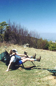 |
| A unique overlook
|
| |


