Trail Daze
¤
The
manifestations of old age proving all too evident.
Elk Garden, VA - Hampton, TN
We’ve been planning on launching our assault on Vermont this month, but the
weather remains daunting, with a bit of snow, lots of rain, and ferocious
winds forecast for much of the trip. Furthermore, the black fly season we’d
hoped to beat has started with a vengeance, so perhaps an alternative section
would suit us better.
Suddenly an idea comes to mind (a phrase certain to be my epitaph). Our time
off includes the last couple days of 'Trail Days', an annual celebration of
the AT in Damascus VA. Last year this event swelled the town’s meager
population of 918 to an incredible 22,000. This section of the trail remained
undone for us, and we can just catch the last day of the festival on the way
through. Sounds like fun.
5/18 Elk Garden- Saunders Shelter (14.4
miles)
"The big question is whether you are going to be able
to say a hearty yes to your adventure."
Joseph Campbell
|
Our morning begins in
typical AT fashion to the sounds of a steady rain on our skylight, with an
early morning departure for Elk Garden, in the Mt Rogers National Recreational
Area (SW VA). It was here we left off on our January hike, and soon we’re
climbing into a sea of cloud, the visibility falling to nothing. We creep our
way into the familiar parking lot, finding a large horse trailer here and
several riders cavorting about.
They're out for a short ride, showing off the horsies to passing hikers; and
we load up, getting into the woods at a surprisingly early 2:00. In spite of
the blanket of cloud, it's wonderfully pleasant climbing out through the
woods, recalling the start of our NJ hike. We wind uphill across Whitetop Mt
road, emerging onto the bald to be besieged by a stout wind, making it tough
just keeping our caps on. There are some beautiful blooming rhododendrons up
here at altitude, but the fog precludes good pix, and we'll have other such
opportunities. As the descent starts, a cavalcade of northbound hikers
begins, including Little Bob, Gary, Liz, and Rez Dog on their thruhike, along
with a variety of both thru and section hikers over the next few days. We
suddenly emerge from the cloud without warning – one minute everything's hazy
around, and suddenly all the trees are clear.
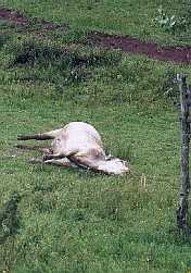
Passing VA 601, the trail winds around a deserted brick house via a pair of
fat-man's squeezers, and as we enter the pasture behind, there’s a dead cow
aside the trail, with all the signs of having been so for quite a while.
We’re easily persuaded to move on before taking our break, but we linger a
minute or so here, looking back at the cloud-enshrouded summit of Whitetop
standing in contrast to the clear skies. At Lost Mountain shelter we take our
break finding it half full of hikers (one asked if there was a climb ahead, to
which the best reply seemed, "yeah, just after you pass the dead cow").
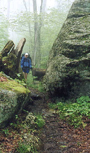
|
| Walking down out of the clouds
|
|
Renewed we shove off into the woods, descending to the Whitetop Laurel Creek
junction, where the AT briefly joins the Virginia Creeper trail, a
rails-to-trails project which is now a popular bike path. The area of their
confluence is replete with picnic, fishing, and possibly camping areas, and it
looks like it'd be an idyllic place to stop for the night, although we'd
rather push on in hopes of more time at Trail Days tomorrow. We cross the
creek on a huge railroad trestle, proceeding down the beautiful creek on easy
trail, with Prairie Home Companion on the radio to entertain our final hour.
At 8:32 we come on the trail to Saunders Shelter – a quarter mile downhill off
the trail, but it seems like a good place to spend the night, so we head down,
finding a quartet of hikes here. Two of the thru-hikers soon retreat to their
tent out back, and we're left here with Tara and the talkative section-hiker
Frito. We have our sandwiches here at the picnic table as Tara huddles in her
sleeping bag, shivering from the cold, and we decide to try sleeping in the
shelter tonight. As Coleen lays out her bedroll however, she finds she's left
her Thermarest at home, being replaced (for our "halfway" party) by a ensolite
pad that'll probably be woefully inadequate. We may have to get her another
at Damascus, but for the now we can tent out behind the shelter among the
pines, using some piles of the needles for additional padding under her side
of the tent. It actually works quite well, and she'll get a good night's
sleep, although just as this crisis is averted, we find she also left the hot
drink sack at home. We'll have to get some replacements tomorrow, and for the
night we have hot water for now (surprisingly good), turning in under clear
skies at 10:40.
|
|
| This can't bode well for us
| |
|
5/19 Saunders – The Place (Damascus, VA) (9.4
miles)
"Abandon all hope, ye who enter here!"
Dante Alighieri – The Divine Comedy
We're up after a good sleep at 06:40, with Frito and the still-cold Tara only
getting around just before we leave. Today my packing skills are found
wanting, finding my deodorant depleted, but it's an easy walk in from here,
descending to follow the creek and the Creeper Trail once again. It's a
beautiful walk, making good time, and soon we’re passing a constant procession
of northbounders. Most share the sentiments of our friends at the shelter,
that Trail Days is far more about alcohol and other bacchanalian delights than
the AT, and that they're glad to be hiking once again. We joke a bit with a
Konnarock trail crew out maintaining the trail, and soon we rejoin the Creeper
Trail again just at the outskirts of town. Even though it's the tail end of
Trail Days ("Tail Days", as one girl points out), there are still many hikers
out and about at every open eating establishment, and as we approach our first
destination – The Place – we see a small crowd outside, with a guitar / dobro
duet being performed in the parking lot.
|
| The Place is a hostel
loosely run by the Methodist Church, and entering via the kitchen we find a
woman who seems to be in charge, though on asking we find it totally
self-serve. A small crowd hovers at the dining room table, scrounging the
hiker box for anything of value, and snapping at tidbits left on the dining
table like a pack of hungry gators. Sleep here would prove elusive, so we
drag our packs upstairs to claim a couple vacant bunks before heading out in
search of food.
Damascus is a typical small town, and a few blocks later we've seen most of
its offerings, though at the far end we find the park still full of vendors,
with a variety of culinary fare to be had. We settle on an excellent fare of
grilled marinated chicken over wild rice and grilled veggies, followed by an
extensive tour of the vendors. We don't buy much as we've 50 more miles to
carry it, but we get a pair of down booties and some other odds and ends,
stopping by Mt Rogers Outfitters to confirm our shuttle and buy a 2nd ensolite
pad for Coleen. Back at The Place, there's little going on (we meet
Sojourner, Philosopher, Big Bird and some odd guy wearing a suit and a rasta
stocking cap who was drafted by Bob Peoples to sing at the Earl Schaefer
memorial – sounds pretty rough), reading a bit before heading out for a
surprisingly good dinner at the Sicily Pizzeria. Our leftover slices are
devoured immediately by a couple girls back at The Place, and we settle in,
although the noise and general debauchery increases as the night goes on.
Several are heading over to Abingdon to see Star Wars II, their expected
return at 10:30 not boding well for an early bedtime. Our attempt at turning
in upstairs proves futile, squelched quickly when one of our roommates leaves
his funky boots here - the unbelievable stench carries well out into the hall.
We finally abandon the bunks and head outside to join the small crowd tenting
in the back yard, which works surprisingly well, with both of us asleep by
11:30.
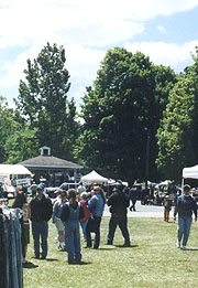
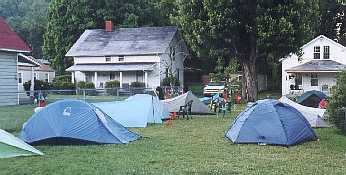
|
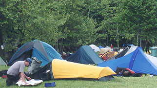
|
| Even at the festivities' end,
there's still a pretty good crowd camping by the river.
|
|
| And here's our little group in the
backyard of 'The Place', where we'd all retreated from the commotion within
|
|
5/20 The Place – Iron Mt tentsite (23.7
miles)

|
"Human beings, who are almost unique in having the
ability to learn from the experience of others,are also remarkable for their
apparent disinclination to do so."
Douglas Adams - The Hitch-Hiker's Guide to the Galaxy
We're awakened several times
as folks come and go, and the typical Dukes of Hazard cars roar down the
streets on occasion. Coleen gets a great night's sleep using her earplugs,
and as first light breaks we're surprised to hear a few hikers up and about.
We find Spiderman wandering about bragging about being up all night; trying to
hit on Angel Hair and Coleen, along with every other girl here as they wake
up. The kitchen fills quickly as the dining room floor remains littered with
sleeping hikers; and luckily we get our water heated and coffee consumed while
there’s still breathing room. Soon there's a big discussion about safety on
the trail, and as one bozo tries to make parallels to aviation safety, I know
it's time to leave.
|
Our backyard neighbors -
Can
you say "white trash"?
|
We're off at 07:12, a refreshingly quiet walk through the sleeping town, and
at the town's end begin the gentle climb up Holston Mountain. It's a
beautiful day for hiking, and we occasionally pass a tarp here and there with
sleeping hikers, totally oblivious to our passing. The VA / TN state line
passes almost unseen, our morning spent in the woods with gentle climbs and
descents, although we do have a nice chat with Hookuks and Sr Chief, a couple
of retired thru-hikers from CT who seem to share our perogatives, being glad
to pull into Damascus after the big fete. He's a submariner and they'd be fun
to hike with – maybe we'll run into them as we start the sections up north.
There are few landmarks, until Abingdon Shelter magically appears ahead at an
early 11:38 – we must be making good time once again. After lunch here (TN
shelters aren't nearly so nice as the VA ones), we push on past an old
emergency shelter (the guide book says it's been here since 1934), and as we
continue the small roller-coaster of hills ahead, the skies surprisingly cloud
up, with the radio indicating a chance of showers and even light snow tonight.
|
|
At Low Gap someone has
taken trail magic to a record level - a cooler stocked with all manner of
beverages, although the Grand Marnier is long-since empty, and the Scotch has
only a few fingers left. This also marks the start of a couple miles of other
trail magic we’d heard of – bags hanging in the trees containing apples, hard
candy, water, and cereal boxes which were allegedly left by Butch Cassidy,
though there’s no sign of a name on any of them. After our pm break begins
the climb up the Iron Mt's – a mere 600', but for some reason it hits us hard.
Nearing the top, a steady rain of ice pellets begins, continuing for some 20
minutes or so – at least it's ice rather than rain, which would have us soaked
by now. Even so, it melts fast enough to make our jackets and packs wet - we
seem to alternate this section between freezing and sweating.
Over a rise at Double Springs Shelter we find an amiable couple of young guys
on a section hike, having just finished finals at MU on Saturday. They drove
all night to Erwin, catching a shuttle first thing Sunday morning to Damascus
(getting chewed out for unloading in the church parking lot), and thence
hiking south to here. They're slowly hiking back to Erwin, and would be fun
to spend the night with were we not driven towards a stay at Kincora tomorrow
night (reminds me of Don & my trip to Colorado after our freshman year).
After TN 91 we enter an area of dense rhododendrons, quickly turning boggy and
dark; and though we find one campsite right on the trail with a bench and
nearby water, we continue in hopes of a more private and cheery one.
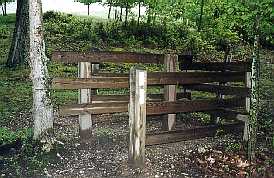
|
| One of many 'Fat Man's
Squeezers'-used to keep the critters where they belong
|
|
Next thing we know we're again climbing Iron Mt, with no hope of level
campsites on the slopes, so in spite of our aching feet and legs we push on
towards the top. Since pulling into TN the profile and actual terrain haven’t
coincided well, so it's tough telling where we are, but finally we reach a
level area at the top, and before long we find a suitable site, with a good
sitting log. Not a moment too soon either, for as we do, the rain begins, so
I hurry to get the tent up as Coleen starts the water for dinner. Finally we
can relax and get into some warm clothes, and soon we're eating as the rain
falls outside, only now confirming that we’ve hiked an incredible 23.7 miles
today. We're comfortable enough, and soon after dinner the rain lets up,
allowing us to finish the camp chores, getting to bed at 9:30.
5/21 Iron Mt – Braemar Castle (18.0
miles)
"No act of kindness, no matter how small, is ever
wasted."
Aesop
We're up at 06:00, feeling renewed after a good night's sleep,
finding our gear slightly dried over the night. It's still cloudy out, and
we're glad to start with a climb to warm us up. Our first goal is the Nick
Grindstaff Monument – a plaque on the chimney of one of the south's most
famous hermits. The story's of little more than passing interest, but it
finally confirms our position, and soon after we come on Iron Mt Shelter,
finding one section hiker here, still huddled in his sleeping bag. We’re
hiking through more trackless woods, though we do have one interesting moment
as we come upon a hen of some type (grouse?) and her chicks in the trail. The
tiny chicks - dozens of them - scurry in every which direction as mom tries to
lead us off to one side with a mournful wail that sounds like a beaten dog.
It was quite a spectacle, and I'd never imagined so many chicks could come
from one brood. We pull up to Vandeventer Shelter a bit earlier than expected
for our lunch break - we'd just passed one northbounder, and we find her three
companions still getting out of the shelter in no particular hurry, so we head
back to the rocks behind the shelter to take our lunch. It's a beautiful
overlook of Wautauga Lake, the skies just starting to clear; but we're cold
enough that we make hot drinks with lunch. There's a lot of giggling coming
from the shelter, and I'm almost afraid to round the corner as we depart, but
we find the last couple here getting ready to head out northbound as we head
south.
At the 1st spring south another thru-hiker is filling her water, and we pass a
few more hikers further down the gentle slope (surprised to find them
northbound this late in the game). As we hike I make the mistake of
suggesting that I couldn't thru-hike the trail with my short attention span,
as some of these featureless sections become boring even on our short treks;
and Coleen somehow turns it into an indictment of me for our long hiking days
this trip. She can't buy my explanation that we've hiked yesterday's long day
to facilitate a stay at Kincora tonight, and soon it devolves into a genuine
spat. As we start our steep and speechless descent she falls well behind, so
I stop to catch up on my notes, finding all seems forgotten as she pulls up.
The trail intersects the Dam Road, which appears to wind around to the left
towards the dam while the trail continues up ahead, climbing around and over a
steep mountain. Once again, it's an integrity test, and we choose integrity,
continuing on the trail, a tough mile of climbing instead of an easy half-mile
of road walk – why do they do this to us? (Or should I say, why do we do this
to ourselves?) We're pleased to see a few bootprints on the actual trail, and
the tribulation is soon over, returning us to a steep road down to the dam.
|
An earth fill dam, Wautauga stands 360' tall and 912' across, with not a soul
around to bother us, so we push across to a convenient rock on the other side
for a quick break. The profile shows we have left a quick 2.5 miles of level
walk, but it turns out to be far from the truth, turning back into the woods
as we climb up and down past the shelter. We're both a bit demoralized (at
least we're just about finished with TN and their inaccurate profiles), but we
push on, with Coleen lagging considerably. The shelter provides a time check,
but hardly an accurate one, the maps being so out of sync with reality; and I
slow quite a bit so for Coleen’s sake. It's a beautiful stretch of trail, the
lake just off our left and beautiful coniferous stands of trees, but we're
both tired and aching, and starting to wonder when we'll ever get to the road
at 321. Finally the trail approaches the road, and as I pull up, I see a
pickup here unloading a hiker, the back end full of others. I ask the driver
if he's Bob Peoples, and on getting a yes, I'm elated, asking if he's got any
space in the hostel. My elation is short-lived, as he replies that they had
44 guests last night, 18 of them tenting outside and many on the floor; and on
asking Coleen what she thinks as she pulls up, I get the short and immature,
"I have to have a bed tonight", drawing an quick gasp from everyone in
the pickup.
|
|
| Finally, the Wautauga Dam
|
|
Bob is very sympathetic, offering to drop us at the nearby Braemar Castle for
the night – a hostel with either bunks or private rooms, suggesting that with
his help, they can slack us to Kincora tomorrow. We climb in the crowded back
end of the pickup, chatting with our fellow hikers on the short trip over
(several have been doing trail maintenance, a party Bob organizes annually),
and in a few minutes we’re at the Castle, a majestic stone building built in
the early 20th century for employees of the Pittsburgh Lumber Company. The
proprietor, Sutton Brown, is out; so we drop our packs on the balcony in
front, and , begin searching the premises. There's a nice room with a double
bed, and several with singles upstairs; with the basic needs including tv,
microwave, etc. Although the floors slope badly, it’s more than adequate, and
Sutton pulls up outside soon after. After meeting him, we decide on the room
with the double bed and private bath ($35), and after making up the bed I talk
Sutton into the use of his phone (an odd pulse / tone combo) to reschedule our
shuttle to 1:30 pm at Kincora.
|
|
After showers our first
priority is dinner - Bob had suggested the "home-cooking – like Ma makes" down
at Jacks, a typical small-town café a few blocks away. We waddle our way
down, finding the typical friendly waitress, and good prices on filling meals.
It's a great meal, and Coleen's appetite exceeds my own, but somehow we get
enough to tide us over. After a few more phone calls we settle down in front
of the tv for our final night out. There are a couple other section hikers
here – one finishing up tonight and another trying to hike down to Springer;
along with Sutton's nephew, who's in college and also stays across the hall.
As we're lounging around, Seiko comes up – a 60-year old, 13 time thru-hiker
(looks far younger than we do) who Bob has enlisted to help slack us tomorrow.
He's fixed up the apartment downstairs in exchange for his rent, and will get
our packs down to Kincora if we check in tomorrow am before leaving, so with
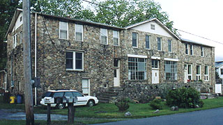
all done we can relax, turning in at 11:30. |
| Braemer Castle, a great respite
from trail life |
|
5/22 Braemar – Kincora Hostel (8.9 miles) "On
tops of mountains, as everywhere to hopeful souls, it is always
morning."
Henry David Thoreau It’s not a bad
night’s sleep despite our being accustomed to a larger bed, and we get up for
good at 06:00. After breakfast we head down to Seiko’s apartment, finding him
up and about (stereo blaring loudly), and offering to drop us at the
trailhead. As Sutton returns, he’s glad to let Seiko drop us, and we chat a
bit more about his 13 hikes, finding he now prefers southbound hiking, with a
preference for tenting, and trying to hike a couple hours nightly after an
early dinner. At the trail head he gives us a couple tips about the trail,
and off we go, with Coleen carrying the light pack to start. It’s amazing to
both of us how easy it is, and it seems we’re racing up Pond Mt without a
care. We get a short but beautiful look at the clouds clearing from the
valley, and soon we’re leveling, far early than imagined. The profile
continues grossly inaccurate, depicting a steady climb followed by a mile of
level before a sharp descent. Instead, there are several sections of climb,
almost no level space at the top, and an equally fragmented descent - steep in
places, but soon we’re beckoned onward by the sound of rushing waters beneath,
the beautiful Laurel Fork surging through the gorge below. It’s a beautiful
setting, and after a short break at the Laurel Fork shelter we push on towards
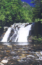
Laurel Creek Falls, our next destination. |
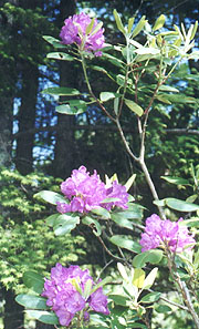
|
| Rhododendron season cometh
|
|
We pull up to the falls
minutes later, and they don’t disappoint, a couple of hikers from yesterday’s
Kincora group wandering around the base. We consider Seiko’s suggested side
trip up an unmarked trail to a subsequent falls, but as we start to climb it
we quickly reconsider, as it’s not only precipitous, but appears to end
quickly. We resume the trek, the path shoehorning majestically between walls
of stone, and soon passing a group of pre-teen girls, led by what appears to
be a Boy Scout leader. The trail levels nicely, leapfrogging the stream, and
in no time at all we pull up to the familiar Dennis Cove road. A quick trip
to the right finds the hostel (after a huge sign suggesting a 180 to the
competing Laurel Creek Cabins), and on pulling in we find Seiko here
performing odd errands and such. Bob’s out on a lunch run; and on asking
about a phone, Seiko suggests that he’ll haul us up to Elk Garden for $25.
This is great both in time and money, so I run in to use the hostel phone to
call Mt Rogers Outfitters, although they tell me Brandt is already on the way
down, so it looks as though we’ll have to wait.
Coleen settles in and is soon besieged by inane stories from Seiko (a better
hiker than story-teller), as I’m making all our needed phone calls. Soon Bob
comes back, taking most of the hiker crowd over to the trail / town on various
missions, and Coleen and I are left alone to wait on our shuttle, which
doesn’t arrive until 13:45. He apologizes for being late, and we head out,
quickly realizing why. He’s one of the most uncomfortable drivers I’ve had in
recent times, slowing for every chipmunk in the road, and downshifting /
upshifting continuously as we meander about the small country roads. He’s got
a good volume of hiking experience, and knows the local area quite well, but
it takes a full 1:40 to get to Elk Garden, our future never quite certain.
It’s always good to get back to the car, our ticket to comfort, town food, and
our own bed.
|
| The beautiful Laurel Creek
Falls |
|
|


