The Windswept Heights
¤
Immense beauty wedded to severe adversity
Franconia Notch NH to Gorham NH
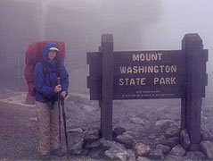
Summer has come with a vengeance, and it's now time to take on the toughest sections of the trail - New Hampshire and southern Maine. It's often said that when a hiker reaches Hanover NH, he's completed 80% of the miles, but only half the work - we'll soon realize how close this is to the truth. Having elected to dive right into the deep end, we set a course for Franconia Notch, in the heart of the White Mountains. Ahead lie the crown jewels of the AT - its longest stretch above treeline, including the Presidentials and Mt Washington, host to the worst weather recorded on earth. We're more than a little apprehensive, and the week to come will prove this section's reputation, in spades.
|
|
6/24 Franconia Notch � Galehead Hut (13 miles)
"Anyone can do the job when things are going right. In this business we play for keeps."
Ernest K. Gann � Fate is the Hunter
After a short and restless night at The Barn (a hostel in Gorham NH, made from an attic connected to a local B&B), the proprietor, Paul, is set to shuttle us to Franconia Notch to begin our adventure. The other hikers with whom we�d spent the night are all getting around, so Pauldrops them off at the trailhead before our shuttle. It�s a glorious clear day out, although even in the valleys the wind is rising, forecast to be gale-force on the exposed Franconia Ridge today (we�re surprisingly na�ve about the challenges this will pose).
With little fanfare we�re dropped in this beautiful park, the trail following a rushing stream into the woods from where the long climb up to the ridgeline begins. It�s surprisingly easy, but goes on quite a while, and I�m almost surprised when we arrive at the Liberty Springs Tentsite at 10:14 � near the top of our initial climb. After a short level segment comes the final 1000� to the ridgeline, breaking out above treeline just before Mt Lincoln � it�s a gorgeous panorama, but the wind immediately proves our adversary. It roars from the west, requiring us to take very short steps between the rocks, as longer leaps result in being knocked down by the wind (we'll find later that the steady wind was clocked at 50-70 mph, with gusts to 83). A surprising number of tourists are here, and as lunchtime comes, we find a large rock formation for a modicum of shelter. After a quick lunch we forge ahead, crossing one minor peak before climbing Mt Lafayette � 2nd only to Mt Washington in the Whites. The wind is particularly intense here, and as the trail turns momentarily into the wind I find to my amusement that I can barely make any headway into it. At least the wind is steadying, which helps a bit, as the gusts were hard to predict and compensate for. The trail turns very rocky on the way down, making every step a challenge, and it�s a relief to finally descend out of the worst winds, for a short break at Garfield Pond.
|
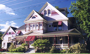
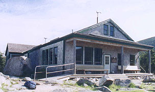
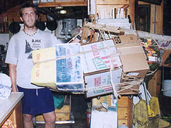
"The Barn" is the little extension on the left
looking like a garage |
|
| A Can you tell we're nearing Maine? |
| Ahead is the final jump over Mt Garfield � a short steep climb, although the descent proves the cruelest joke by the trail architects we�ve yet seen. It takes us straight down a rocky creek bed, seemingly vertical, with the stream ensuring that all the rocks in the bed are wet and slippery. It�s amazing that no one�s been killed here, but soon finally we reach the bottom, where the trail continues towards Galehead Hut. We'd planned on camping in this area, having read that the Hut was being renovated, but now we find the Hut in full operation, which leaves us in a quandary. As we approach it, we look around for possible campsites in case it�s full, only finding one satisfactory one, and it a full .6 mile before the Hut. As we�re coming up on the Hut we find some possible stealth sites, and pulling up to the Hut itself (6:40) we find it chock full, with dinner being served. It�s a beautiful hut, with an odd wind generator atop humming away, along with solar panels and a battery array. We drop our packs on the benches outside and find our way to the kitchen, finding Beth (Asst Hutmaster) in charge, from whom we find they�re booked to capacity. She�s glad to offer us a work-for-stay though (sleeping in the dining room), suggesting we sit outside until dinner is done, at which time we can help clean up.
Soon it�s time to pick up after, and though we�re not allowed to help wash, we are allowed to clear, rinse and such, and soon all�s cleaned up, and the croo sit down to eat. They�ve run out of the guests� stir-fry, but offer us some ham, mac & cheese, and whatever else is around; and we add our own stuff, just glad to have a level place to sleep for the night. We all chat a bit around the table, and as the evening winds down the kids take over the main hall playing games as I catch up on my journal and some books here. It�s a nice atmosphere, even if the only sleeping accommodations are the floor and mattresses. Lights out is supposed to be 9:30, but it�s delayed until 9:45, with a few guests staying up with headlamps after, although they quickly lose interest. A few stay up to watch a gorgeous moonrise over the adjacent mountain (full moon tonight), and finally we�re able to lay out our mattresses in the empty dining hall, nodding off at 10:10.
6/25 Galehead � Crawford Notch Campground (14.7 miles)
"A near tragedy � the first week out on the expedition someone lost the bottle-opener, and for the rest of the trip we had to subsist on food and water."
W.C. Fields
|
|
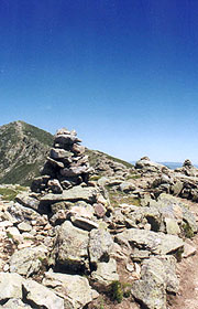
| With no trees to blaze, stone cairns mark the trail above timberline |
|
Braced against the 70 mph
wind atop Mt Lafayette |
|
We sleep well, but the sun blazes through the generous windows early, and even with my bag over my head I only manage to sleep until 5:45. The guests are coming around, and at 6:30 reveille is sounded with the pots and pans, our cue to start setting tables. The croo has a well-organized system of getting meal service done, with the customary skit on Hut etiquette afterwards. After cleanup, we take our sumptuous meals with the croo as the guests head out for their individual hikes, finding it a warm but cloudy, and surprisingly calm day out. We begin with a short steep climb over South Twin and a fairly easy trail towards Mt Guyot, swarmed by the gnats every time we slow.
Our huge breakfast allows us to forego our am break, and though it seems an eternity, we push on to Zealand Falls Hut for lunch, unable to find a bug-free space elsewhere. It�s a small but welcome hut, fronted by the beautiful surging Whitewall Brook just prior (along with a strange engine that we�ll find uses water power for their energy needs). During a long stop here (to give our sweltering feet a welcome break), we chat with the croo about work for stay for section hikers. One of the girls works on the Lakes croo, and is sure they�d love to have us work-stay there tomorrow night � a great relief as there�s no other campsites nearby, and they�re chock full with paying guests.
Thus relieved, we return to a rare level section of trail, using a former railroad grade for the final miles to Ethan Pond. We�re due a break here, and want to see this pond surrounded by Tamarack Pines, an odd deciduous conifer that actually sheds its needles annually. The side trail reaches the pond at an apparent dead end at the water�s edge, but after pondering for a moment, we see a blue blaze on one of the large stones out in the lake. We find the shelter trail actually crosses the water on a series of boulders offshore, tiptoeing across, though we�re immediately swarmed by the bugs on arrival. The caretaker comes by as we're slathering on our DEET, saying that the gnats now tormenting us are actually the famed black flies (I�d always thought they were much bigger critters), famous for their ferocity and the long-lasting bites. Another section hiker comes in, followed soon after by a pair of SOBO�s - it�s a shame we have to leave; but finally we have to return to the trail for our planned stay at Crawford Notch.
| Galehead Hut with (no kidding) - a wheelchair access ramp on the left, should any such guests wish to helicopter in (required on Federal land by the Americans with Disabilities Act) |
|
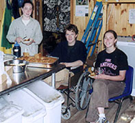
| The "Croo" | |
|
Coleen pulls out her new MP3 player as we push off the easy miles, finding it a welcome addition to our gear. She mentions that she�s never heard one of the songs I put in the list (Out in the Country, by Three Dog Night), and I explain it was popular the summer I went to Boy Scout Leadership camp � the summer after which my Mom claims �she couldn�t tell me anything anymore�. Coleen�s comment was that no one�s told me anything for a very long time � a pretty caustic comment, considering that I�m carrying the tent and rain threatens for the night. The miles wind down quickly, and soon we�re at Crawford Notch, where we�d been assured of an easy hitch. We�ve heard of numerous campsites aside the river, but Coleen�s excited by stories of the lavish showers at the campgrounds (we�ve also found Crawford Hostel is closed), so we put out our thumbs and wait. And wait. And wait. It�s dinner hour, and what little traffic comes by is all going the wrong way � not only that; we quickly find that the hordes of single women in SUV�s won�t even think about giving us a hitch. We finally decide we�ll give it till 7:25 before abandoning the hope of showers for a riverside campsite when a small black economy car swerves over braking mightily towards us. A fellow hiker who was also out on Lafayette yesterday, he helps us stuff into the car for the quick 1.8 miles down to the campground, finding we may have crossed paths yesterday on the ridge.
|
|
| Easiest trail all week |
At the campground the rain starts immediately, so we pick a vacant site and get the tent up promptly, though the rain stops as quickly as it started. We pull the picnic table over by our tent and start dinner, (a picnic table is SO handy for camping), with the ranger pulling in to collect our fees as we do. It�s $15 for the campground, and on asking about change, he lets us put another couple bucks on our check in exchange for a pile of quarters (alas, no soda machine though). Coleen heads down for her shower, determined to take the full 12 minute maximum, although it takes her about :45 before her return in the dark. Mine is next (wonderful, but 6 minutes is plenty), using the hand drier in the bathroom to dry the shirt I�d used as a towel. I find my way back to the site where we settle in at 10:09, although soon after a truck comes plowing through the adjoining site - between their noise, headlights, and a little worry about them backing over our dark-colored tent, we won�t get to sleep until they finally disperse for the last time just after midnight.
|
6/26 Crawford Notch � Lake of the Clouds Hut (11.2 miles)
"I saw the lightning�s gleaming rod,
reach forth and write upon the sky,
the awful autograph of God.
Joaquin Miller - The Ship in the Desert"
|
 |
It�s another short night, but again, my summer sleeping bag proves too hot, even in my skivvies. We�re up at 5:45, and with some major climbing to do today (and no options other than the Lakes Hut), we want to get an early start. We�re waiting at the road side with thumbs out in an hour, the hitch proving every bit as difficult as last night. We finally decide that at 7:30 we�ll start walking, but once again, at 7:25 our salvation comes � a couple of young ladies and their dogs heading out for a hike (one with a couple kayaks strapped atop). We�re very appreciative, and find them also heading up Mt Washington (via a shorter trail - our driver hopes picking us up might betide good karma for their hike) With gracious thanks we begin our trek - easy enough to start, but with mounting temperature and humidity, it turns into one of those killer climbs that goes on endlessly. The lack of any useful signs or distance information makes it that much worse, and it�s an incredible relief to finally pull out on a ledge where we catch a little breeze and a look at Rt 302 below.
| Praying for a breeze on Webster Cliffs |
|
|
Coleen thinks we�ve summited Mt Webster and are approaching Mt Jackson, but from the view of the Willey House below, I�m skeptical. Unfortunately, I turn out to be right on this one, the climb up the Webster Cliffs continuing for an eternity, quickly depleting the mere liter of water each of us brought for the climb (we�d actually had the audacity to pour out the excess at the bottom of the climb). The lack of water, heat, and humidity wear on us quickly, and it�s a great relief to finally summit Jackson, from which it�s a fairly easy hike up to the Mizpah Spring Hut for our lunch. We down a ton of water, after which we both take off our boots and socks to give our sweaty feet a rest. I find that the hot spot on my RH foot is a rather large blister that looks ready to pop at any step, so it seems best to lance and duct tape it, against Coleen's objections.
It doesn�t feel any better climbing out after lunch, but we�ve less than 5 miles left up to Lakes, so we push on, beginning with a fairly steep climb up Mt Pierce. We break out above treeline, passed by a trio of young boys wearing identical tan slacks,white golf shirts, and New Balance tennies � they look a lot like Mormon missionaries, and refer to each other as �Brother __�. Soon comes another trio, and another, and another; and we�ll spend the afternoon with small groups of these energetic boys flying past us, although we sometimes pass them as they go off on searches of summits the AT bypasses. We proceed through the alpine krummholtz and the open ridgeline, the trail still quite rocky and precipitous, and often hard to follow. At the Eisenhower Loop, the AT on Crawford Path diverges from all the boys heading up to the summit, and we find our path a narrow corridor between the scrub brush, often far narrower than our bodies, much less our packs. It�s tough going (the summit might have been easier), and a relief to rejoin the loop, even if it means stopping every few minutes to allow another group of the boys to fly past us (though by now they�ve slowed considerably).
|
|
Suddenly the rock-strewn Mt Washington comes into view, and soon after the Hut itself � we arrive at an incredible 4:10, far earlier than our earlier progress today would have indicated. Even Coleen (who�d been talking about quitting just a few minutes before) is energized, and we�re pleased to find Annie, who we�d met at Zealand Falls Hut yesterday, serving as Asst Hutmaster (for some odd reason, all the Hutmasters take the same days off). She welcomes us to our work-stay, and as we�re getting settled in, Kyle (croo) comes down from the summit with 115 lbs - no kidding - of supplies on his packboard. This is a very fun croo (there are 10 of them, due to the hut�s size, and this position is highly sought-after), and they immediately give us the chance to help out washing dishes. Here we find Mother Goose � a 5-time AT thru-hiker, also here on a work-stay washing dishes as she�s currently out hiking the ECT on a cancer fund-raiser. She�s perhaps the most down-to-earth thru-hiker we�ve met yet � a charming lady from KY, and we hit it off immediately. As time approaches to set tables, a group of the boys we�d been leapfrogging start to gather, and we find they�re Catholic Seminary students, out for a few days hiking. They were all headed back to the bus atop Mt Washington, but the weather gurus radioed the Hut here, advising the croo to hold everyone here in light of a rapidly approaching thunderstorm. It erupts spectacularly before dinner, and we�re all craned at the windows watching the fireworks until time to set up.
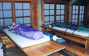
Dinner tonight is lasagna, with the thunderstorm as a backdrop, and a few guests straggle in during the meal, having been stranded out on the ridge during the storm, one couple having even felt the tingle of electricity during some nearby lightning strikes. We set them up at a couple of small tables in the reading room, already crowded with the stranded Seminary students and a few other hikers caught out similarly. As we're clearing dinner, one guy breaks out his guitar for a singalong, and the Seminarians treat us to some acapella chants as well. Finally the all-clear is sounded from atop, and the stranded hikers all depart, returning the Hut to its normal slightly-crowded state (90 guests) as we wash dishes and have dinner with the croo. It�s a fun time here, and as before, lights out is at 9:30, by which time we�re seriously tired, dragging our mattresses out to sleep on tables in the dining room (although guitar boy is still holding a card game by headlamp at the next table). It makes little difference � in minutes I�m sound asleep in spite of them.
|
|
"Why are the Huts so expensive?", you ask.
Maybe because the Croo bring the food in on their packboards |
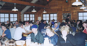
|
Feeding the masses at Lake of the Clouds -
sometimes referred to as "Lake of the Crowds" |
|
6/27 Lake of the Clouds � Osgood Tentsites (10 miles)
"I felt as if I were walking with destiny, and that all my past life had been but a preparation for this hour and this trial."
Winston Churchill - The Gathering Storm.
I awaken at 5:45 to the sound of a howling wind outside, the Hut enveloped in a dense fog. The Lake of the Clouds Hut lives up to its namesake, and Coleen seriously doubts the wisdom of continuing, especially as Mother Goose contemplates an escape route to the bottom, bypassing the Great Gulf Loop. This is her 5th thru-hike, every one of which the summit of Mt Washington�s been totally wrapped in cloud, so she doesn�t feel bad about bailing on the loop, although our motives are different. (It's worth noting that the highest recorded winds on the earth's surface were an astounding 223 mph here). We�d considered getting started early today in hopes of making it all the way to Pinkham Notch for an indoor stay tonight, but now it appears we�d better wait for a weather report before doing anything. As everyone gets up and around, we set up tables, with the weather report coming in during breakfast of 25-60 mph winds, and 50� visibility on top, with clearing down low throughout the day, although the summits may remain clouded. Coleen wants badly to abort, but I can�t see anything unsafe about it (although I know it won�t be much fun). After cleaning up and having an excellent breakfast with the croo (entertained by one very gay but entertaining croo member, relating his story about falling into the fecal pit while cleaning it), it's finally time to fish or cut bait.
Somehow I talk Coleen into hiking out, so we load up and head out, struck immediately by the wind as we round the Hut - it'll be a major challenge on the wet rocks. We have to walk very carefully, and my cap is immediately blown into the lake, but at least the wind's pushing us up the mountain. A few others are out on the climb, and on hearing Coleen tell one that she�s quitting at the top - no matter what; I see my work�s cut out for me. She soon breaks into sobbing, and I take a few minutes to hug her and assure her it�ll be alright, but it�s obvious she�s pretty scared. We pass a row of packs lined up at the Westside trail junction (??), and the wind intensifies as we approach the top, with a strange howling as the trail levels. As we get in close, the source of the howling � the radio tower, appears out of the fog (it's the eeriest thing, hearing buildings before seeing them), and we can barely find our way to the visitors center. We find shelter here, a dozen or so tourists wandering around; and we head downstairs first to drop our packs. Coleen�s in pretty bad shape, with no intention whatsoever of proceeding (she�ll �walk down the auto road if she has to�). In the drying room a couple of Boy Scout leaders are packing up, telling me they�re leading a group of boys north to Madison Hut (the packs we saw on the ridge were theirs, as several in their assembly were disabled). We drop our gear and head upstairs to the snack bar for coffee as I plead my case with Coleen (the fact that the disabled Boy Scouts are out here not lost on me). I�m convinced that it�ll be safe if not fun, and that the weather will probably clear over the next few hours.
|
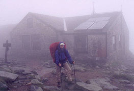
| Shelter from the storm - the milky white in the windows is a pea-soup fog with 50 mph winds
|
|
| What the heck are we doing out in this stuff?
|
|
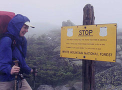
| The legend reads, "The area ahead has the worst weather in America. Many have died there from exposure, even in the summer. Turn back now if the weather is bad."
|
|
It's one of my life's toughest sales jobs, but somehow, I prevail, so after a quick peek at the forecast (the wind is steady now at 45 mph) we head out. We can't even find the trail in the murk, requiring a return inside for specific directions. Even so, we turn too soon going out the door, ending up on the observation deck, where we're almost blown ove by the gale; but we quickly return downstairs and find the suggested trail down. Now we're heading into the wind, but it�s not too bad, improving slightly as we head down. The scariest part comes when we have to cross the elevated cog railway, with a scant 50� visibility, and having just heard the whistle blow from the top. If he�s going above 10 mph, he�d run us down before seeing us, but luckily we get across never knowing how far away he was. The visibility improves significantly as we descend, and intersecting the Westside Trail, we run into the rear detachment of Boy Scouts and leaders.
|
|
| It's an eerie thing hearing buildings before seeing them in the howling wind |
|
A break in the clouds offers a momentary view of the valley, and approaching Sphinx Col, the breaks become more frequent, the clouds quickly clearing almost completely. At the bottom of the Col, the wind roars through, but the skies have cleared, making the summit periodically visible, and soon after we find a sheltered spot for our late lunch. We climb around Mt Jefferson and descend into Edmunds Col, soon thereafter hearing the boys ahead making quite a bit of noise.
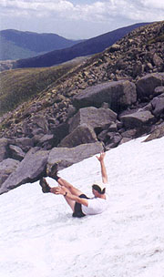
Rounding the corner we�ll find them gathered in a ravine full of snow, some snowball fighting, others �sledding� down the steep slope. They load up as we approach, and I can�t resist having a try myself, though Coleen prefers to sit it out. In my shorts, there�s that �snow enema� sensation, and it�s really rough ground underneath(and very hard on my palms trying to stop). I only hope the picture comes out, as my palms will be numb for a couple miles. We drive on as the rocky trail intensifies, with the blister on my right foot becoming more and more painful.
Our stop at Madison Springs Hut proves a good chance for first aid, finding it�s now a massive sore too big for a moleskin patch, so I make several strategic pieces of moleskin to surround the area, putting a large strip of duct tape over the whole affair. The black flies swarm heavily down here, and several of the guests from the last two huts are here as well. We chat with the croo member for a bit (he�d love us to do a work-stay here), but we�ve miles to go if we�re to get to Gorham Saturday, so we finally push on for the dreaded climb over Mt Madison. It�s only about 500� up, but it�s a total rockpile, and we'd been warned by Mother Goose about thunderstorms here, although looking about, it appears we'll beat them across. It�s an arduous climb, but the descent is far worse, continuing down a series of cornices that go on endlessly. Each time we get to the end of one, another appears below, each one as rocky as the last. We can see Rt 16 in the valley below � so close, and yet so far � but the descent is an eternity, our pace not even 1 mph. Even as we finally reach treeline, the trail remains as rocky as ever � a continuous climb down, with every step being a couple feet to a treacherous perch. Worse, the rain begins at 8:00, and we�ve no idea how far we�ve got to go to anywhere. The rain continues solidly and we keep descending with Coleen in the lead, finally yelling out that she�s at the Osgood sign at 8:55. It�s too dark to see much of the sign, but she tries a left turn, and in a few minutes we come on a tent platform.
In the dense rain we�ll be lucky if everything isn�t soaked, so my plan is to set up the tent under her poncho as she�s heading down to a nearby stream for water (we�ve had the pack covers on for some time, but our clothes are soaked). This works fairly well, and I�m just putting it up as she returns, with her plan being to strip naked outside, then climb inside with her essential gear, to remain there. This actually works pretty well, and once she�s inside, I start separating my stuff outside, throwing it inside as appropriate, and finally following her lead as to clothes. We put on dry clothes inside, and the next order of business is dinner, cooking just outside the tent door. It works out pretty well, and we�re comfortable enough, though a bit crowded, with the tent fly touching the tent at the ends, requiring us to keep everything inside clear of the fabric if it�s to stay dry. After a bit, Coleen needs to head back out for a bathroom break, so I make some guy lines for the rain fly and coach her on how to secure these to the tent platform (my foot�s so bad now that I can barely walk). She finishes the outside chores, doing a good job with her first attempt at tying the taut-line hitch; and with everything done, we both turn in to bed at 11:10.
|
| How to get a snow enema without even trying
|
 |
| Mt Madison proves a little slice of hell with its miles of rocks
|
|
6/28 Osgood Tentsites - Carter Notch Hut (10.7 miles)
"In the fell clutch of circumstance
I have not winced nor cried aloud.
Under the bludgeonings of chance
My head is bloody, but unbowed."
William Henley-Echoes IV
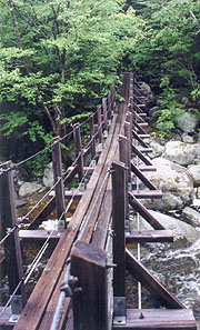
It's soupy and cloudy outside, with little hope of drying anything, and we even start out with pack covers on as all the tree branches are covered with rain. We're afoot 7:17, never having seen the caretaker, starting with the downhill to Pinkham Notch - a bit of trail advertised as following an old railroad grade. Though we'd been looking forward to this for days, it remains as rough and rocky as before until the final mile, and the only thing of interest is a suspension bridge over the Peabody River. Finally we get to the RR grade, and our speed picks up a bit, reaching the busy Pinkham Notch area at 10:20.
|
|
At the Visitors Center my priority is to work on my badly hurting right foot as Coleen starts working on water and such. She's been trying since yesterday to talk me into stopping the hike here, but it'd be tough to pick up the last 21 miles at a later date. I start to think she might be right though when I pull away the duct tape and see the damage to my foot. There's a massive blue-gray blister surrounded by a red area which she says might indicate infection. We�ve got a tough day ahead, and it�s a tough call whether to pull out here or not, but finally I decide to lance it and proceed. I extract some fluid of ketchup-like color and consistency, and it takes some pretty creative moleskin work to keep the sore away from the bootsole, but between this and a couple Advil, I deem myself worthy to continue. Coleen drops a bag of our wet clothes and other unneeded supplies at the Joe Dodge lodge, where they�ve agreed to store them until we drive back through tomorrow, and I find a Diet Coke to spur me on. After an hour we�re ready to forge ahead, beginning with a blessed mile of level trail winding around Lost Pond.
The light sprinkle falling clears quickly as we start the climb up Wildcat Ridge - every bit as tough as expected. The Advil masks my foot pain, but it�s not helping my energy level, and every few steps of the climb are followed by a rest stop � for both of us. Coleen�s still leading (as she has been the last day), but she�s every bit as fatigued as I, and much of the climb is done on all fours, with the poles stowed. It�s getting horribly muggy as well, and it�s a great relief to pull out on one of the ledges midway up for a momentary breeze. We grab a quick lunch on one of the ledges, finally reaching the ski gondola terminal at the summit of Peak E � the first of the 5 Wildcat peaks we�ll summit (creative name, huh?). The black flies force us to get out our DEET, and the trail turns into continuous ups and downs for the next several miles before finally starting the steep descent into Carter Notch. It�s brutal for me, my foot hurting at every step, and Coleen quickly pulling ahead. Worse, the rain begins again (some thunder to our south, but none near us), and the slippery rocks and steep descent really slow the pace.
|
|
| Suspension bridge over Peabody Creek |
It�s 6:00 when I pull into Carter Notch, hobbling down the rocky trail to the shelter, a beautiful setting between a couple of ponds in the narrow mountain gap. Coleen�s been here just a few minutes, but to our surprise we find Swedish Cowboy here with the SOBO Dawn. Cowboy�s given Coleen a trail report from ahead, having seen some campsites up at Zeta Pass, but none he can recall prior, and with the weather uncertain and my foot barely usable, it seems prudent to stay. There�s one open room at the bunk house, and we get everything carted up (Coleen doing the lion�s share of the work) and unloaded, bringing our food down to cook. There�s 6-8 other guests here, and we chat with them over dinner (this is a self-service hut � �only� $21 each, but we�re on our own for meals), along with Lydia and Pete of the croo. A little later a few croo from other huts come over to stay the night, and I fall asleep on one of the benches in the hut soon. As I wake a few minutes later, we decide to retire to our bunkroom, getting to bed at 9:10.
6/29 Carter Notch Hut - Gorham (15.2 miles)
"Let us therefore brace ourselves to our duties, and so bear ourselves that,
if the British Empire and Commonwealth last for a thousand years, men will still say,
"This was their finest hour."
Winston Churchill- Speech to House of Commons
The night is full of distractions - at 03:00 the croo making their 24-hr tour of all 8 huts start their wakeup process, which lasts a full hour, culminated by the sound of one of the guys peeing off the railing in front of our cabin. I can't sleep on my right side, which puts my bruised ankle and blister under the other leg, both far too tender for this; so I alternate between my back and the left side. Finally at 05:00 and first light, I find Coleen's up; so we start the prep for our long and arduous day - one whose end is far from certain. My foot still hurts badly, and even with feet of tape and mounds of moleskin, the best I can manage is a painful limp. Coleen suggests she take the tent today, which I willingly allow,in return for her lighter food sack. We pack up in the dim glow of dawn, and soon she heads down to the restroom and lodge, with me slowly joining, using my pole as a cane.
 |
Inside we find Dawn, and we share the pleasantries with her as we put on some water for coffee and warm our breakfast. I lance my blister again, putting moleskin on three sides around it, and securing the whole mess with duct tape for a passable solution, but it's the Ibuprofin that really makes it work. We don't get out until 6:52, starting the 1500' climb up Carter Dome, which proves surprisingly easy for me and difficult for Coleen. She lags behind most of the climb, which is typically difficult, but at least my foot doesn't bother me much in going uphill. The summit is wide open with a good tenting space where a fire tower once stood, but it's too late for that now, and after one look back at the now clear Mt Washington and the other Prezzies, we continue on over Mt Hight. It's an absolutely gorgeous clear day, and I'm doing surprisingly well so far, making good time down to Zeta Pass, finding a number of good tentsites here as well. We climb South Carter Mt, stopping for a break, and meeting a peak-bagger we saw last night at the hut. The black flies swarm us here, so on goes the 1st DEET application, and we head across the small gulfs to the Middle and North Carter Peaks, making only slightly better than typical NH pace.
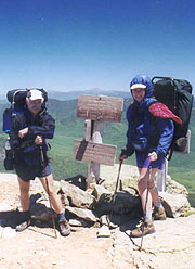
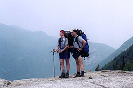
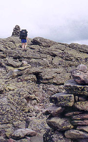
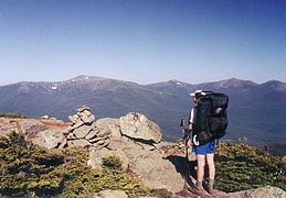
| Finally - a beautiful panorama of our week's work |
|
We finally arrive at the trail to Imp Campsite, taking our lunch here, although the weekenders keep passing through our ersatz dining area; so we're all too glad to pack up and head onward towards the goal. There's a few ups and downs, but the final big climb is towards Mt Moriah - only 700', but owing to its shallow grade, one that takes an eternity. It's made worse by the sight ofa group standing atop the summit a LONG way away, but finally we arrive there, ushering in our day's final descent, starting easily enough, but quickly steepening.
By now my Ibuprofen's worn off, so I let Coleen take the lead, and we pass Moose and Willow - a couple SOBO's who started 6/3. The final grueling portion levels somewhat as we repeatedly leapfrog the Rattle Run creek, initially an easy crossing, but more difficult as we continue down. The clear rushing waters make us thirst for more, but our bottles are nearly empty, and we're not obliged to get out the filter now (haven't used it all week). Finally we pass the Rattle Run shelter, by which time the trail's not only leveled nicely, but has a nice terrain underfoot as well. I'm listening to Coleen's MP3 player as we cover the remaining miles, and as I come to the theme from Silverado, Coleen can't remember it, so I give it to her to listen to, which picks up her pace to a solid 2.5 mph. I can barely keep up, and worse, the mosquitoes beseige me in this stretch, attacking through through my shirt. I have to stop to reapply the DEET, but suddenly I see Coleen dancing a little ahead, and our adventure is over.
Our hitch into Gorham is with a young girl that's a weatherman at Mt Washington, working an 8-days-on, 6-off shift year-round (12 hour shifts) - a fitting close to our trek. It's unbelievable ecstasy letting the automobile put the miles behind us after our grueling week, and we're elated like no section before - we're hurting, but WE'VE TACKLED THE PRESIDENTIALS!!
| | |


