Over the Hump
¤
A long awaited Milestone
Duncannon PA - Pine Grove Furnace SP
It's been a long time in coming, but finally the anticipated day is upon us - with this section we'll be halfway to Katahdin! Even though we've been hiking north in the summer and south in the winter, we've saved this small section of PA for this moment - crossing the trail's midpoint as we reach our personal one. It seems like only yesterday we took our first steps on the trail, but we're getting more seasoned by the minute. We're looking forward to a major celebration at the section's end, and oh, by the way - we'll be done forever with the famed Pennsylvania rocks.
|
|
2/22 Duncannon - Wentz Rd tentsite (14.2 miles)
" No man is an Island, entire of itself;
every man is a piece of the Continent, a part of the main;....any
man's death diminishes me, because I am involved in Mankind;
therefore never send to know for whom the bell tolls; It tolls for
thee."
John Donne, Meditation XVII
|
|
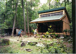
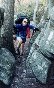
Our milestone trek begins at downtown Duncannon, the trail passing through downtown and past the legendary Doyle Hotel (renowned in AT circles for cheap beer) before finally turning into the woods. The trail climbs to Hawk Rock, a splendid overlook, though the rock itself is covered with ugly graffiti and paint, and the cloudy skies don't lend themselves to photography. With surprising speed we come on the Cove Mt shelter trail, taking us a bit by surprise as we'd expected the Thelma Marks shelter. We take our lunch here, finding it a new, clean and very nice shelter, with bunks, a picnic table, the most immense fire pit we've ever seen, and by far the best food hangers anywhere on the AT. The site of the famous 1990 murders of Geoff Hood and Molly LaRue, a little research finds that the former shelter was razed in 2000, replaced by this new shelter to exorcise the site of this grisly spectacle. There is no mention here whatsoever of how that fateful day brought them to this shelter the same night as Paul Crews (their killer), but it remains a tale of trail lore and a powerful demonstration that we are not always the masters of our own destiny.
|
|
The old and new shelters during replacement
Photo from The Virginian Pilot |
|
This afternoon's decision is whether to stop at Darlington Shelter, or to continue past and camp in Cumberland Valley - the latter strictly prohibited in our literature and on signs in the shelters. Darlington will come a bit early to end our day (making our next two that much longer), but we also have to consider the chance of being chased off our tentsite in the middle of the night. When we reach Darlington, we're feeling lucky (or contrary), so after a short break we push on, our decision soon buttressed by the acres of forest we see stretching into the valley - surely we can find a secluded location in such a forest. It's a long and gentle downhill to PA 944, with a surprisingly forested locale both before and after this noisy road. After passing, we'll need a little distance to escape the noise, and we find ourselves following a small creek that looks adequate for water, with a modest strand of trees on either side. There are numerous good sites for camping, although we occasionally pass within sight of houses on either side. We forge ahead seeking the perfect site as darkness approaches, and soon we come on a concentration of houses that suggests we'd better return to one of the previous choices. |
Goeff Hood & Molly Larue during their ill-fated thru-hike
Photo from The Virginian Pilot |
After a short search I select a small level rise east of the creek with a couple sitting logs, and on getting there we're both surprised to find a fire pit as well - I knew someone had camped here before. We find a leak in our water bag, but manage to work around it, and a fire proves easy with the abundance of dry wood. Unfortunately, Coleen's moving the fire pit near the sitting log puts it a bit too close, and whenever we sit before the fire the back draft from the constant west wind pulls smoke back into our faces. Still, we linger around the fire quite a bit, the clouds thinning enough for occasional peaks at the moon, and eventually the stars as well. The evening chill sets in quickly, and after a 2nd round of hot drinks we settle into the tent, turning in at 9:30.
|
2/23 Wentz Rd - Old Town Mt Rd tent site (19.1 miles)
Whatever you can do or dream you can, begin it.
Boldness has genius, power, and magic in it.
Wolfgang Goethe
|
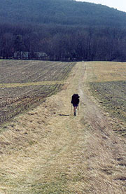
| I'm up with first light, finding Coleen up as well (she'd been cold until I added my jacket to cover her), though it's typically tough getting her out of the bag. The Cat Stove again performs flawlessly, our coffee staving off the morning chill. Today we look forward to perhaps the easiest section of the entire trail - a 12 mile walk, flat as the proverbial pancake across Cumberland Valley - traversing pasture, meadow, farmland, and scattered woods. It's still cloudy as we get to the trail, compassing a several housing developments as it joins Conodoguinet Creek - the mouthful of a creek we'd thought we were on last night. It's far bigger than we'd thought, with numerous ducks who we retreat upstream as we hike behind. At the Scott Farm Work Center, we find an AT bulletin board and a water tap, which we're surprised to see turned on at this date. After filling our bottles we cross the bridge to walk in the narrow strip between the creek and Bernhisel road - our eventual crossing for I-81 (3rd time we've crossed this artery thus far). Before the interstate, the trail fans out through a couple of pastoral farms and meadows - one with newly planted wheat, crossing between properties on well-maintained stiles. The trail clubs have done an excellent job of minimizing the road walk (all 12 miles used to be on the roads), and after crossing I-81 we return to the fields and the narrow strip of woods between a large trucking yard on our right and occasional housing / mobile home parks to our left.
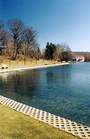
The trail threads between homes and industries, crossing US 11 on a fenced-in pedestrian bridge, and thence the PA Turnpike; where a mammoth flock of squawking birds orbit overhead. We chase them ahead of us as we continue, the noise incredible; and it's a minor miracle that we weren't covered in white when they finally part paths a mile later. The homes past here are very upscale, and numerous day-hikers are out - many not even hikers, just parents and their kids out for a walk. The sky clears, and soon we take a break in a hedgerow between corn fields, with a well-mannered dog (Charlie) coming over in search of food. His owner comes by just behind to apologize and return him to the corn field, where they seem to be doing some sort of weeding. We also pass an older couple heading out for their daily walk, and after expressing their amazement at our hiking in shorts, they suggest Anile's in Boiling Springs for a town lunch. Soon we're there, finding it as idyllic as expected, with the ATC Regional Office on the shores of a gorgeous spring-fed lake. After a brief chat with a couple hikers here, we head over to Anile's for town food, finding it only a couple blocks walk.
It's an Italian place with a limited menu and their patience is tried a bit by a large group of kids filling the place, but we eventually submit our orders, Coleen downing coffee by the pot to stave off the cold. After lunch of considerable size, we wander around the lake and chat with the locals, seeing the town's namesake spring (whose 53F temperature creates the "boiling" designation). Town is crowded with folks out for this glorious Saturday, and the stream below the lake is full of trout fisherman as well. It's almost a disappointment to leave town, where the path crosses a series of farming fields in square corners. Finally our serpentine path across the fields ends as we climb into the woods up Center Point Knob - once the midpoint of the trail. It's surprisingly rocky (we'd erred in thinking all the rocks were north of the Susquehanna River), with numerous day hikers out, and a beautiful overlook here. A short walk past is the Alec Kennedy shelter, too far off trail for a stop, and we drive on towards Whiskey Spring Road, intending to camp somewhere past tonight. There's a few ups and downs yet, but finally we descend to the road, with several campsites just prior, but it's noisy and looks like a party haven. No doubt the kids will be here in force tonight as the sun goes down and the road earns its namesake. We'd wanted to get a bit further anyway, and the map shows a level area a couple miles hence, so we fill our water at the spring here and head on.
The climb out is amazingly rocky, and at the top it surprisingly winds through a maze of huge rock formations we'll later find to be called the apt "Rocky Ridge". We almost suspect we've been misdirected by some miscreant youth, but finally we emerge from the rocky maze, finding a fair campsite on an overlook at its end. We consider stopping here, but it looks a bit exposed and rocky, lacking any close firewood; so we push on, immediately regretting our choice. It's a fair descent before the trail starts to level, but soon we read Old Town Road, with level ground after, and sites plentiful. We choose one, hauling a fire ring over from another as the light starts to fade, and getting the tent up quickly and fire going - the waxing moon rising high enough that we've quite a bit of light even after the sun sets. We get supper going, relaxing in front of the fire for our final evening (now we've put the fire pit too far from the log, so we spend much of our time standing around the fire). The evening chills cold quickly, so after cocoa, we hang the food and turn in at 9:40.
|
|
| A beautiful Saturday at the equally beautiful Boiling Spings |
|
| Cruisin' the easiest 12 miles of the AT |
|
| A final assault by the PA rocks |
|
2/24 Old Town Mt Rd - Pine Grove Furnace (11.8 miles)
"It's the cursed cold, and it's got right hold
till I'm chilled clean through to the bone
Yet 'tain't being dead -- it's my awful dread
of the icy grave that pains;
So I want you to swear, that foul or fair,
you'll cremate my last remains."
Robert Service - The Cremation of Sam McGee
It's a tough night for sleep, starting off too cold for me, though I finally get up and put on my rain pants, making it bearable. At first light it takes considerable effort to get Coleen out of her bag, finding the inside of the tent covered with frost, and the water bottles in our packs partially frozen (the thermometer shows 16F). My camp shoes do nothing to keep my feet warm, and I quickly don the boots, but even then, they're quickly painfully cold. The Cat stove gets the water to a rolling boil, and we're stoked at the thought of crossing the halfway point before noon, so we quickly pack our frigid camp and get underway at 7:40, both of us wearing our rain pants.
|
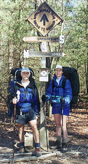
It's a shallow monotonous descent towards PA 94, followed by a hop over Trent Hill and another descent to PA 34, another busy road after which we join a RR tracks a short bit before easing off into the woods. It's easy trail, and we make good time, counting the minutes to Tagg Run, after which the trail turns back uphill. Finally we warm up and start shedding clothes, and as we reach the top we take a quick break, anticipating an early completion. We both shed our rain pants here, a bit cool at first, though the temp is climbing through 40F (our water remains icy though). Our final climb up Piney Mt quickly becomes rocky across the top - one last reminder of the character of the AT in PA, and it's quite a relief to finally leave them behind. Once the descent begins in earnest we know we're nearing the end, following a forest service road and passing numerous weekenders - the park must be near. We finally come on the long-awaited sign for the halfway point, stopping for a pix, and as we're trying to balance the camera to catch us, a couple of weekenders come through to help.
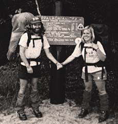
The park follows just after, and though it's a beautiful park, it's much further to our car than anticipated. It's a tad confusing to follow, but eventually we find the road leading to our car (answering numerous questions on the way). We've done it!! - we're halfway, and the appropriate ceremony at this point is to consume a half-gallon of ice cream in one sitting (we're going to cheat a little and share it). Since the general store here is closed for the season, we hightail it to the nearby Mini-mart, buying a half-gallon of premium ice cream (Chocolate Rain Forest - they didn't have the more appropriate "Rocky Road"). We get about 2/3 through before crying "uncle", but even if we're wimps at the sin of gluttony, we're HALFWAY DONE with the AT, and no one can take that from us (besides, we've other sins at which we really excel).
|
| Halfway Done!!! |
| |
| |


