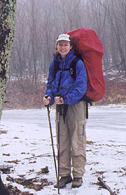
The Pony Express
¤
Wild horses couldn't drive me away
Burke's Garden VA to Elk Garden VA
The entire airline world is depressed by the fallout from Sept 11 as well as the recession, - my employer no exception. Having decided not to fly the hajj this year (the Muslim pilgrimage to Mecca), we found ourselves with far more planes than business. Our bottom 21 crew were found hostage to their seniority with a New Year's furlough, and the bottom 10 captains (including myself) were similarly downgraded to copilot rank. My return to the peasantry wasn't altogether bad though, as my seniority as a copilot was impressive indeed, giving me first choice of time off and destinations.
Of course, in the cruelty of fate, all this time off came in the month of January - a month we've not yet attempted to hike. Still, it's been a mild winter, and a section of southwest Virginia beckons to us - Grayson Highlands, filled with feral (wild) ponies running through high grasslands reminiscent of Wyoming. By all accounts, it looks to be a cakewalk.
|
|
1/23 Garden Mt-Lynn Camp Mt campsite (13.3 miles)
"When thou passest through the waters, I will be with thee,
and through the rivers, they shall not overflow thee."
Isaiah 43:2
|
|
Just outside the bucolic Troutdale VA is the Fox Hill Inn, a lavish B & B managed by Mark & Janet, a pair of AT icons. Having launched on their pilgrimage to Katahdin in '95 as Full Moon & Celestial Spirit, they found refuge here during their hike, and returned afterwards to offer their services as innkeepers. Mark has reluctantly consented to shuttle us from our destination to the remote intersection where we intend to begin - his reluctance rising from his uncertainty of the road conditions of the winding gravel road leading to the latter. It's generally a sign of wisdom to heed the advice of locals about weather and road conditions - it certainly would have been on this day.
We wind through the numerous small roads towards Garden Mt, swapping trail tales with Mark, and finally reaching the 7-mile gravel road to the trail. Our pending challenge becomes obvious, as the streams here are flooded well over their banks, and I ponder how we'll cross the many flooded streams as we hike. Soon we're driving on unmelted snow and ice, the many rivulets cutting deep ruts through the road. Mark drives like a pro though the shaded areas which conceal glare ice topped with a treacherous coating of water. I have to get out a couple of times to remove debris ahead and to check the water depth in the washouts, but finally we make it to the top - another sheet of ice. Mark chooses the route ahead to Burkes Garden as a safer escape, though we're both skeptical, knowing that it'll be steeper and icier on this face. We wish him luck and with our prayers he disappears around the curve at a snail's pace. This is the first time our shuttle has ever proven a challenge to the driver, and it's ironic to think that Mark's probably far closer to harm's way driving back to the Inn than we are hiking there.
|
|
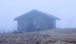
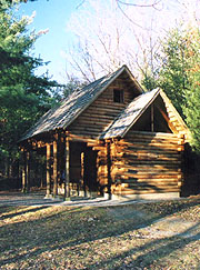
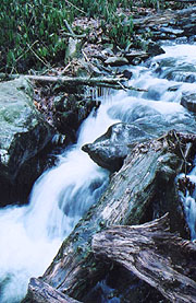
| An Icy Garden Mt - now to get down. |
|
It's a bit icy climbing out, but soon we're cruising the ridge line, amused immediately by a small sign proclaiming "View", though our view is limited to a few scant feet of the gray cocoon around us. To our right is the renowned "God's Thumbprint", although His fog is all we'll see today. Walker Gap heralds the climb to Chestnut Knob - our only real climb for the day; and though it's easy enough, I'll have my sleeves rolled up by the top. It's a relief to pull out onto a bald at the summit, though the wind blows mightily here, with sheets of cloud sailing by. From the wood's edge I can just see the foggy outline of the shelter, and we're surprised to find a fully-enclosed fire warden's cabin. It's an effort to pull open the door against the gale, but inside are tables and bunks, though the wind still roars overhead as if to blow the roof off. We have our dinner sandwiches here by candlelight as darkness falls - our mere 25 minutes here seems an eternity in the howling wind, making us cold just listening. We're glad to hit the trail again, though even finding it in the foggy dusk proves a challenge. |
| A brief respite from the gale |
| Finally we find the jeep trail heading south - a tough, rocky trail filled with water or mud in many places. Our headlamps come out, but the fog is so thick that we can't wear them on our heads, the fog's reflection blinding us to the trail. Holding them below waist level works passably, and soon the trail spills out onto the bald. Navigation here is even more tenuous, the blazes very widely spaced and no other sign of the trail save one slightly-trodden strip of grass. We forge ahead in the night, grateful for each blaze we pass, and it's a real relief when the trail finally re-enters the woods, descending out of the the fog and wind. Here it's quite pleasant, our headlamps working as intended, the trail easy, and the temperature quite comfortable sans the wind. I remember thinking that I could cruise indefinitely in this comfort, little supposing that we will. Looking ahead, I dimly see a pair of long white streaks plunging down the hillside ahead, and on turning off my light, I realize that the ghostly spectacle are two surging streams formed across our path. It's amazing that enough ambient light exists to clearly illuminate them without our lights - must be moonlight above the clouds, as there are no towns of size anywhere near us.
We cross the torrents easily enough, and soon we cross USFS 222, putting us far enough to make Davis Path shelter tomorrow. It's drearily dank and musty down here in dense rhododendrons though, so we press on towards that perfect spot. Our hopes are dashed at Poor Valley stream - a solid 20' of rushing water with no rocks or logs on which to cross. A test with my pole finds it at least knee depth, and to either side of the trail are dense rhododendron thickets that can't be penetrated. A short backtrack finds no alternatives, not even a palatable camping spot down in this hollow. There's really only one choice left, so off come my boots and socks, for our first attempt at a stream ford (something we hadn't expected until Maine). It's icy cold, with a swift current, but it doesn't go much past my knees, and seconds later I'm across. The opposite bank is covered in snow, so I lay back on my pack to lift my feet above it as I quickly get my boots and socks back on. My feet are so cold after these few seconds that even my wet socks and boots feel like they're a jacuzzi by way of contrast. After some brief pointers to Coleen on how to negotiate this (sternum and waist straps undone, in case she's knocked down), I stand ready to catch her as she crosses, equally exciting, but trouble-free.
Our hearts are now pounding with adrenaline - even though it's nearing 9:00, we're wide awake as we approach Lick Creek, finding an abundance of campsites, with groves of balsamic fir trees about. The sites along its side are too near the water for comfort (and the roar of the waters a bit loud), so we cross the bridge and look at sites on the far side. Nothing catches our eye, so we wander down the path, which soon turns up Lynn Camp Mt. We're both resolute that we won't climb this mountain tonight, but there appear to be some good sites just up the rise. The perfect site always appears just over the next rise, and I keep searching with Coleen a ways behind, but soon hit the point where we're too far up to consider going back. Coleen's heartily angry with me now, my error obvious - there's no hope of a spot on the steep slope now, and we should have retreated to a lower spot long ago. With profuse apology, I talk Coleen into continuing, hurrying to the top in hopes of finding that elusive spot there. As I round the mountain's edge, I lose sight of Coleen's light, and yelling back to ask if she needs help, I hear a faint "yes". I find her trying to bushwack her way straight up the slope off the trail, having lost the path while trying to head straight for my headlamp. After pulling her back up onto the trail, we stick together, and moments later hit the summit, with a good campsite right at the apex.
We know immediately that here we'll spend the night, so we quickly set up the tent and have a midnight snack as we get the bear bag hung and our bedrolls laid. Finally, we can relax, and even under the drizzly skies enough moonlight sifts through that we can do our camp chores without using lights. Soon all's put away, and our long day comes to an end - after icy and flooded roads, blinding fog, an icy stream fording, and hiking well into the night we turn in for a well-deserved sleep at 11:45.
|
1/24 Lynn Camp Mt - Atkins VA (16.2 miles)
"An adventure is only an inconvenience rightly considered.
An inconvenience is only an adventure wrongly considered."
G. K. Chesterton
|
| We awake to an stunningly beautiful sunny morning, and looking out we see all the valleys about filled with fog, reflecting that we'd be immersed in same had we stopped earlier as intended last night. We start heating coffee and breakfast, but the western sky suddenly darkens and the next range of mountains grays before it's done. We're about to get hammered, and we quickly pull down our drying clothes, pulling the heating water under the vestibule and everything we'll need towards the tent. In seconds a mighty wind rises, unleashing the thunderstorm - incredible in the speed of its onset. We've had just enough warning to get the critical stuff inside, but now we have to break camp in a pouring rain with no sign of a reprieve - just seconds ago we thought we'd be hiking on a beautiful day.
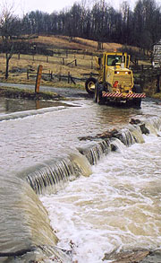
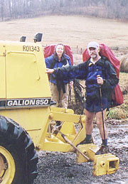
By 9:15 we're away, descending in the rain to Lynn Camp Creek, and crossing here on a sturdy bridge before starting the gentle climb past the Knot Maul shelter. We stop here for a quick break and a check of the register before forging ahead towards the O'Lystery Picnic Area. This area includes a nice picnic shelter right on the AT, although past abuses have made it verboten for AT hikers; even our shuttler Mark has a story about stealth-camping here with men out looking for him. But since it's pouring rain out, we'll try to sneak a quick break here, hoping for a water tap as well. It's empty as expected, and we decide on an early lunch here, finding no potable water, but filtering from the adjacent stream. None of the few passing cars stop to chase us off, and the rain lightens as we go, the path heading over a series of stiles and gently descending through several pastoral meadows to the North Fork of the Holston River. Wingfoot's guide shows a low-water bridge here that's frequently impassable, the alternative being a 1.4 mile backtrack to follow a series of roads around this hazard - definitely not our first choice. Hiking downhill towards the bridge though, we see a road maintenance crew pulling up on the other side, several of them already leaning against their shovels.
The bridge is badly awash, with little sign that it was even a bridge once, and we ponder what to do next, the gap spanning about 50' of swift-running water to unknown depth. After staring across at the road crew for a minute, we shout across to them, negotiating a ride across on the grader. We're surprised as he crosses how shallow it is - we probably could have forded it, but it would have been a long, frigid ford in bare feet. After profuse thanks we head down the trail towards the woods, and as we climb the switchbacked hill we see the crew depart - how lucky we were that their passing coincided exactly with our own! From atop the hill we break out into a beautiful meadow, descending on a circuitous path to cross 610 and begin our climb up to Tilson Gap. The area is full of stiles, making it a stepper exercise, and the rain gives way to mid-level clouds, so it's not unpleasant walking. Since we're making good time, I pull out my intel and offer Coleen an alternative to our planned shelter night - another hour or so further lies the town of Atkins, with the Village Motel.
|
|
| We get by with a little help from our friends |
|
|
She's elated at the idea, and we push forward with speed, Coleen's town night not to be denied. As our path ascends to the ridgeline, a strong NW wind rises, the sky again darkening to the west and the rain beginning resuming as well. By the time we reach Davis Path shelter, the efficacy of our plan is confirmed, and after a quick break, we descend towards Atkins, the path fanning out through a series of meadows. It's pleasant walking despite the now continuous rain, and a sign indicates the headwaters of the middle fork of the Holston River - odd, as we're to cross this fork tomorrow at a higher elevation, and I've never known rivers to flow uphill. Darkness has fallen as we enter town in a steady rain, finding the Exxon Truck Stop here closed, but the Village Inn open just past; and the elderly man running the office hands me a registration form that I can barely complete with my frigid fingers. He's also unsure how to work the CC machine, so we pay cash for the room, but we're elated to be out of the rain.
The room is crude and frigid, and Coleen heads staight for the shower as I unpack, using all the hot water as I'll find about a minute into my own shower. I'm chilled to the bone as I put back on my wet boots for the rainy trudge up the hill to the Barn, our only dining choice as the restaurant here is closed. It's a raw walk up, but in this typical small-town caf�, we're able to get coffee in abundance, with massive portions of food and wonderful pecan pie. We're chilled again on return to the room, but it's warmed up now, and our gear is gradually drying, so we're able to relax in front of the tv, with all indications being that our weather will clear tomorrow. The registers are covered with drying boots and socks, and we've got gear hanging everywhere, with jackets draped over the lamps. We finally turn in at 11:15, though the heat and road noise prevent sleep for some time.
|
1/25 Atkins - Partnership Shelter (11.5 miles)
"He began to think the tramp a fine, brotherly, generous fellow. He was also growing accustomed to something�shall I call it an olfactory bar�that had hitherto kept them apart."
H. G. Wells - Bealby
Our restless night dawns to a glorious clear day, with the last of the clouds rapidly leaving the area, and a touch of frost in the air. We're out by 8:55, the trail starting through the low marshes, crossed on treacherously slippery puncheons, covered with a thin film of frost. The trail then marches uphill into a beautiful rhododendron and mountain laurel forest as it winds along the surging Vaught Hollow Brook. Beautiful as it is, it becomes an obstacle, with 7 crossings ahead, many with water well over all the bedrock. With some manipulation of the rocks and logs, we eventually build a path across with the larger rocks barely submerged; and we're able to cross without totally soaking our boots and socks. Each successive crossing is a bit easier than the last, and finally we pull up to the Chatfield Shelter, finding a large green tarp suspended over one half of it, with a grizzled old man appearing from behind it (and what appears to be a fire pit inside the shelter). A real talker, he ostensibly started in Oct from MD, arriving via hitching and walking to this point (probably more the former). He has an odd combination of info from reading shelter registers and talking to other hikers; and as Coleen's off at the privy, he copies what info he can from my notes and maps. He's southbound, trying to hitch to Damascus; and as we pull away we both wonder if we might see him at Partnership shelter tonight.
|
With a wave to "Boxcar Willie" we cross the creek again in front of the shelter, and a couple more times as we continue, but they're all easy crossings from here. Soon we're atop Glade Mt, the easy but featureless trail winding around the slopes towards the afternoon goal - the Partnership shelter in the Mt Rogers Recreation Area (though it's noteworthy that this afternoon we'll cross the 1000 mile point). Soon we hear the roar of Rt 16, and at an early 3:27 we pull up to the ranger station here, dropping our packs just beyond at the shelter. The shelter itself is nothing short of spectacular, sitting in the edge of a pine glade, with a nice fire pit and picnic table out front, a full loft atop, and a shower to the side, although the water's been secured for the winter (it's too cold for a shower anyway). We head back to the ranger station to sort it all out, and as Coleen heads inside for some intel, I check messages on the pay phone outside, elated to find our company business soaring (no pun intended), which probably signals an imminent return to the captain's chair. There are several interesting and informative exhibits inside, and after their perusal, we head outside to order a pizza delivery from Marion - a fitting celebration of our 1000 miles and good business fortunes.
|
|
We've just enough time to head back to the shelter and get into our warm clothes, stowing our gear in the warmer (?) loft, and collecting firewood for our return. The Ranger station closes at 4:30, but Ciro's is used to delivering pizza at the locked gate afterwards, so we head back down, where moments later the pizza shows up. We dive in before the crackling fire as night settles in, making a surprising dent in the huge pizza , with only a couple pieces left for later. Our liter of Diet Coke is surprisingly refreshing at its ice-cold temperature, although we're getting cold ourselves, and we linger next to the fire for the whole of the evening. The full moon rises early, casting sharp shadows around the campsite, and it's a great evening, although we settle for our DC supply instead of the usual hot drinks. We have the last of the pizza for a late night snack, turning in to the loft at 10:00.
|
|
| An omen of things to come? |
|
1/26 Partnership - Fox Hill Inn (Troutdale, VA) (14.6 miles)
If you can imagine it, You can achieve it. If you can dream it, You can become it. -- William Arthur Ward
We're up at 7:00, Coleen having slept poorly in the cold, and moving down from the loft we find another beautifully clear, cloud-free day out, a little chilly at 30F. We start with a nice forest walk with few landmarks until the South Fork of the Holston River, crossed on a 120' long footbridge, finding we're making good time today. After lunch is the pm climb to High Point, passing a couple shelters as we push on towards Dickey Gap, from where we plan on hitching to the Fox Hill Inn (the B&B run by our shuttler, Mark) . We get the thumbs up, with several rejections before a pickup turns back for us, driver Lee having sized us up and counted us worthy (he'd secured a similar ride recently when his truck broke down).
|
|
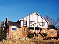
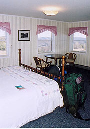
He drops us at the Trading Post at Troutdale, where I call Mark at the Inn, who fills me in on the excitement of his drive back from our shuttle, promising a pickup in :20. The food stocks here are meager but we select a can of chili, one of corn, and a bag of taco chips to add to our beans and rice dinner for a nice Mexican skillet. Soon Mark pulls up (not before a lengthy conversation with an elderly local, impelled to chat at length with us while his wife waits impatiently in the car), and moments later we're climbing the steep drive to the Inn. Breaking out atop we find the view spectacular, with a commanding view of mountains all around, fronted by a beautiful meadow. The heat's off inside (the Inn having been vacant over winter) and Mark turns it on as he shows us around. Our room is gorgeous, and there's a library with plenty of books I'd like to read; along with a living room with satellite tv and the full kitchen, ours for the use. Soon we're cleaned up and our wonderful dinner done (Jeez, how we're eating these days - it's incredible that we consume it all without being stuffed), and we're lounging around the house, Coleen taking an extended bath as I go through the book collections. Mark comes over, and we all chat about the trail and such for a couple hours, with us not turning in until 11:00.
|
|
| A wonderful break from sleeping out |
|
1/27 Fox Hill - Wise Shelter (16.0 miles)
"A friend might well be reckoned the masterpiece of nature."
Ralph Waldo Emerson
We've arranged with Mark to do breakfast at 0730, so after a superb night's sleep, I head downstairs to find he's already started, with coffee made. It's a great breakfast, with blueberry/pecan pancakes, bacon, and strawberry / orange slices, and topped off with lots of coffee and OJ (interrupted momentarily by the deer lounging around outside as we dine). After settling up and taking some pix, we load up, and head for the trail, our stay here a high point of the trek. We leave Mark with our web address for his perusal, and reluctantly say our goodbyes and start. We feel very energized this morning, making good time on this, our long day; and as the trail winds through the woods our first stop is at Comers Creek Falls for pix.
|
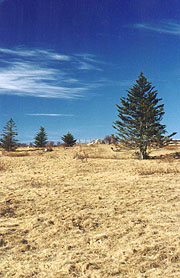
Soon our first climb (Iron Mt) begins, and we huff and puff our way uphill, still making a good pace. We stop for the am break shortly on the sunny side, and soon we're over it, heading back downhill to the VA 603 crossing we remember from the car. There's a beautiful log bridge across Fox Creek, and at the other side begin the day's 2nd climb, through a beautiful coniferous forest towards Pine Mt. Approaching Old Orchard shelter we see a couple weekenders having lunch just prior - odd as they're only 100 yards or so from the shelter. Hiking up to the shelter for our own lunch, we see why - yep, it's "Willie", having hitched to the parking lot below, and hiked up, where he's taken over this shelter for a few days. We take a quick lunch chatting with him; but we're resolved to get to the Wise shelter tonight - the first stop inside Grayson Highlands, where we hope to see the feral ponies. At the summit of Pine Mt we see the first of the high grasslands we'd been reading about - they're truly gorgeous, very reminiscent of Montana, compassed with fir forest. We reflect on its beauty, thinking that this might easily compete with that day at Bear Mt NY as our favorite day on the trail.
We wind around the edge of the grassland on Pine Mt, the fir forest filled with perfect campsites, and replete with rushing streams and huge rocks. Even though the rocks and occasional sheet ice slow us a bit, we love it up here, and soon we emerge back into the grasslands descending to a large horse corral in a saddle - "The Scales" on our map. After a quick rest we start the climb through the meadow with only scattered scrub pines up here. The trail is extremely eroded, a narrow muddy trench, and it's a toss-up whether to walk in the mud, or try to negotiate the prickly grasses on either side. Still, it's so scenic that we don't mind; but soon we're back to the woods, following an old jeep trail that's badly washed out in sections - it seems instead of the Appalachian Trail we're walking the Appalachian Canal. It's a relief to return to the meadows, though as we descend we enter the shadow of the huge mountains ahead, where it cools quickly. Here we find the rushing Wilson Creek, and soon after we come upon the shelter, where seeing no ponies around and feeling ravenous, we promptly start on dinner.
Firewood is sparse, although a nearby grove of trees yields a small pile of thin pieces, which we save for darkness. Coleen's worried about getting cold tonight and wants to set up the tent within the shelter, but yields to my suggestion of using the tent to cover our sleeping bags instead. After a slightly larger than normal dinner I start the fire, pulling the picnic table over close to it as our long evening wanes. We have a couple of hot drinks each, and the full moon rises directly in front of us, a beautiful evening if ever there was one - we even go out wandering around the meadow a bit, the moon's brilliance illuminating the surrounding mountains like the midday sun. The firewood lasts until 9:00, and we turn in, smiling, at 9:50.
|
|
| The icy Comers Creek Falls Grayson Highlands |
|
|
1/28 Wise Shelter - Elk Garden (9.4 miles)
"Up in a meadow in Jasper, Alberta -
two men and four ponies on a long lonesome ride
To see the high country and learn of her people -
the ways that they lived there, the ways that they died"
John Denver - Rocky Mountain Suite
|
|
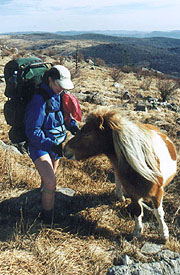
The tent works well as a covering, keeping us both toasty all night. At first light I rouse Coleen for our final day, lingering around the shelter a bit in hopes that the feral ponies will drop by. They never do, so we load up and head up the trail on this clear and mild day, with a continuous climb the first couple hours into the highlands. Much of the trail is awash and rocky, and it's a relief when we finally break out of the scrub woods to the grasslands along Wilburn Ridge - a perfect place for the ponies and a great campsite, but alas, none are here. We keep winding around a large rock formation and suddenly, we come across a trio of ponies. Their indifference to us is monumental until I reach into my fanny pack for my camera, and suddenly one sees it and heads our way. They're pretty savvy despite their unkempt appearance, not wanting to be petted or otherwise bothered unless food is involved. One in particular tries to take a mouthful out of my fanny pack and later from Coleen's Thermarest - obviously not a well-developed sense of smell. Another insists on eating with his teeth, giving me a nip that leaves me with a blood blister on my hand.
Continuing, we're awed with the grasslands' beauty climbing past Massie Gap. All too soon we leave the park, but just as we comment how lucky we were to see the ponies, we round another rock outcropping to find a small herd - 16 this time! After a few more pix we trudge on uphill, soon coming to the Fatman Squeezer Tunnel - a narrow tunnel with a thick layer of ice at its bottom, but wide enough to traverse with packs on. From here it's a short trip to the Thomas Knob shelter and the Mt Rogers side trail (the highest peak in VA), but as the summit is forested and without views, so the allure of our car and town food impels us onward. We scare up a trio of deer here, but don't linger long, the trail turning wet and icy again as it winds through the woods. Soon we come to a broad saddle, in the middle of which we see a small sign. As we hike down to it we find a glorious view of the valley below, including the parking lot where our car is parked, and our spirit is further lifted by the sign showing a mere 2.3 miles to Elk Garden - we'll be there well before 2:00 - earlier than planned.
Heading down the path there's no sign of a white blaze, and at the bottom of the saddle is a gate that would certainly be blazed were this the AT. After searching the map, it appears the AT wanders somewhere to our north, although it's a steep slope back up in this direction, with a dense forest across the fence. It takes a bit of integrity to to climb back up and search for find the AT (it'd be so easy to take this shortcut to the car), and we finally have to go all the way back to the last stile, finding the trail had taken an abrupt right turn without the requisite double blaze. We've been snookered big time, and having paid for it with a tough climb and :20 of our time, we head back up the trail, which adds insult to injury by turning extremely rocky. I'm eager to get back to the car, and soon Coleen lags behind, especially as the descent begins in earnest. Finally I break out onto a high meadow, over the crest of which our car comes into view, looking far cleaner than we left it. I hurry down, with Coleen arriving a few minutes later, another month's adventure over - we've had it all this trek - the challenges, the stunning beauty, the hospitality of new friends. We're glad to return to our life of ease, but it's been a great hike, and I sense we'll be back here soon.
|
| If you feed one wild pony---
|
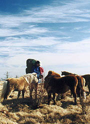 |
| You'd better be prepared to feed them all.
|
| | | | |


