Unfinished Business
¤
Getting back on the horse that bucked you
Reel Brook Trail (NH) - Hanover NH
Last July the Great Appalachian Adventure came screeching to a halt following Coleen's tumble near the base of South Kinsman Mountain in western NH. Now, two orthroscopic surgeries later, her knees are returned to hiking shape, and this aborted section looms as one of our three remaining hikes, with Mt Moosilauke heralding the last of the rugged White Mountains. With three months before Katahdin's closing, and three hikes left, it's now or never.
|
9/5 Reel Brook Trail – Gordon Pond (3.2 AT miles)
"I know what I have to do - I have to keep breathing.
Because tomorrow the sun will rise.
And who knows what the tide will bring in."
William Broyles Jr. - 'Castaway'
In an all-too-familiar scene we pull again into Dartmouth College's visitor parking to find our shuttler Charlie waiting next to an empty space. It's deja vu as we clamber into his pickup, filling him in on our progress since he last shuttled us on this route. Following a minimal detour we again pass under the familiar power lines and up to the Christmas Tree farm from which we stumbled off the trail last July. We bid our farewells and launch up the slope, under the familiar power lines in the surprisingly sunny weather, with only the tops of the Kinsmans obscured in cloud. It's a muggy climb, but surprisingly easy, with a few stretches remaining familiar. Somewhere ahead we’ll have to diverge from the powerlines and head south, though even when we get to a promising intersection, it’s quite unfamiliar. Still, even in the woods it’s easy path (although we have to rock-hop Reel Brook a few more times than desired), and before long we’re up on the ridge line. The grade levels, but the AT is nowhere to be found, and after a sizeable traverse I’m starting to doubt our navigation.
|
|
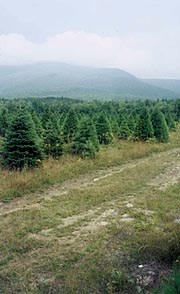
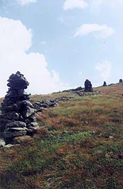
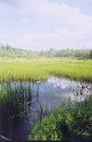
| The Reel Brook trailhead, where we abandoned last year's hike after Coleen's fall - South Kinsman Mt extends into the clouds in the distance |
|
Finally the familiar sign comes into view, pointing us southward, though we’re immediately reminded that we’re still in NH, as the easy trail we’d followed up the power lines is replaced by an obstacle course of rocks and roots – much tougher than expected, even with the fairly gradual climb over Mt Wolf. We climb into a sea of cloud, soon followed by rain; and the muddy trail only amplifies the difficulty of the rocks. I’m thinking about our car back at Lot A when I remember that I hadn’t locked and hibernated the laptop, meaning that: 1. It’ll be out of power on our return, and 2. A thief would have full access to my files and such. Although my passwords are well concealed, I think of several vulnerabilities, and it troubles me more than it should for next few days (though precious little could be done now). Furthermore, it's positively dismal weather and trail; and darkness is falling quickly when finally we run across the side trail down to Gordon Pond. It’s a ways downhill, passing a couple side trails to the left, although we continue downhill in hopes of finding the pond itself. Soon we reach a brook that we’re able to rock hop, finding on the other side a small muddy campsite just off the trail, and further down the trail the pond’s edge, although we can't see much save the nearby algae in the thick fog and vanishing light.It’s a bit depressing, but we hear voices off to our left, near the side trails. I yell in that direction, getting no reply; but we decide to try the side trails in hopes of better sites there.
|
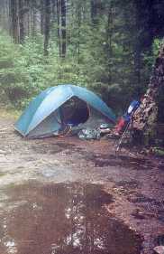
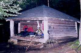
| Our damp Gordon Pond tentsite |
|
It's a good choice, as a short walk down one trail takes us to a couple individual tents, and a slightly better site just past both. A small clear brook feeds the pond here, and we decide to camp nearby, Coleen convincing me to eschew the large muddy flat area to shoehorn the tent into a small more protected space nearby. We set the tent up quickly in case of more rain, sitting on a log here to dine on our sandwiches. We’ve only been out a few hours, yet our clothes are already a bit funky, and we’ll do a quick creek cleanup, hanging the bear bag and turning in on this murky night at 10:15, although we won’t get to sleep for several hours hence.
8/6 Gordon Pond - Glencliff NH (12.8 miles)
"There is a degree of mercy beyond which any man is rude to inquire."
Ernest Gann - Fate is the Hunter
It’s a tough night for sleep, getting a late start, and then interrupted by a torrential downpour in the wee hours of the morning. I finally rouse Coleen at 7:30, finding she’s been up for a while as well. Our two neighbors depart quietly moments before ourselves, and just as we’re wondering when we’ll see the first northbounder’s, we run into Swift Sandals and Two Steps, a nice couple rapidly closing in on their trek’s end. There’s no lack of ups and downs, but soon we descend into Kinsman Notch, where the weather’s clearing enough for a quick look at most of Moosilauke ahead. As I reach for the camera though, I find there’s a small puddle of water in the bottom of its bag, but a quick drying and cleanup finds it working as intended, and moments later we’re crossing the several tributaries of Beaver Brook (oddly, only the narrowest of which seem to be bridged).
As the trail turns uphill an ominous sign proclaims, “This trail is extremely tough – if you are not experienced, choose another route.” Our 1900+ miles of AT should be plenty experience though, so up we climb, following the beautiful and mighty cascades of Beaver Brook under clearing skies, with beams of sunlight splaying through the trees. The path climbs steeply over slippery rocks, but numerous wooden steps are bolted thereto, along with occasional rebar handholds. Numerous NOBO’s pass us on the way, and eventually the trail parts with the cascades, after which we take our break, along with an additional stop later before leaving our water source. Passing the Beaver Brook Shelter the slope ebbs slightly (though no less rocky), continuing over the Mt Blue summit where we re-enter the clouds with occasional rain, Soon afterward we hear a loud thunderclap booming from the mist, followed by a few more peals of thunder before the rain breaks out in earnest – and just as we’re leaving the treeline for the final .4 mile climb. It’s severe enough that we retreat back to the Benton Trail, finding a small pocket of shelter under a few scrub trees for us to take refuge. We stand shivering a few minutes before the rain abates, and with the thunder now retreating as well, we decide to gut out the final climb in the rain. We resume the climb, and just as we break out into the open, the rain suddenly comes to a halt, with the sky opening to reveal a spectacular view to the west.
Our good fortune is rare indeed - none of the hikers we’d passed had any views, and I break out the cameras for a few pix at the summit, marked by the remains of the former Prospect Hotel, which burned to the ground in 1942. The clouds return quickly, and Coleen heads on down the descent on the old carriage road as I'm finishing. The thunder booms again, and with the first drops of rain I sense we should get below timberline before the lightning begins in earnest. Coleen is a bit down the trail fussing with her jacket, and I urge her to hurry in light of our safety. By the time she catches up to me she’s ready to lose her jacket again, so after a final wardrobe adjustment we resume the descent, steep and rocky at first, but soon shallowing to a number of pastoral meadows. The mosquitoes come out, forcing a DEET application, and the Jeffers Brook Shelter trail gives us a chance of a quick look-see before continuing on to town (we'd worried about space at the hostel, but in spite of a nice empty shelter here, we elect to chance it and move on). The final approach to town traverses a couple roads, eventually getting to NH 25 after a short ford of Jeffers Brook that’s almost a rock hop.
The Hikers Welcome hostel is .2 east, so we head east into the small town, finding the hostel as expected – just across the street from the nondescript Post Office. Inside is a sign with the prices shown, and 4 hikers sitting around who fill us in on the rudiments of our stay here. We throw our gear upstairs (no one knows who’s sleeping where yet), and head to the bathhouse outside for showers (in hopes of a town food trip when Packrat comes back), although by the time he does, the few choices in Warren are closed. We find a microwave though, using it to heat water for our meals (adding the tuna packet to a rice medley), with a couple cans of soda for a nice change. Some of the hikers have rented the movie Bringing Down the House to play on a small marginal tv here, but long before it’s done we’re ready to retire, heading upstairs to the loft to claim some mattress space. My mattresses are overly soft in the middle, giving the feel of sleeping in a hammock, but we’re able to turn in at 10:00 with minimal lights left on, and various other hikers retiring over the next several hours.
|
|
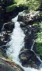
| The trail climbs along the Beaver Brook cascades |
|
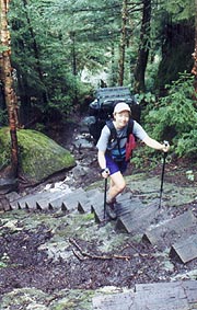
| Some helpful steps on the steep climb |
|
| The thunderstorms part for a quick look at the Moosilauke summit |
8/7 Glencliff - Hexacuba Shelter (14.7 miles)
"As God is my witness they're not going to lick me!
I'm going to live through this and when it's all over, I'll never be hungry again!
No, nor any of my folk. If I have to lie, steal, cheat or kill!
As God is my witness, I'll never be hungry again!"
Margaret Mitchell - 'Gone with the Wind'
|
|
We’re awakened at 6:00 by noisy truck traffic outside, and after coffee, breakfast, and paying up (a mere $18.50 for everything), we’re out early, with exceptionally easy trail at first, though we climb steeply back into the fog atop the aptly named Mt Mist for a bit. Descending to NH 25C our break time comes, finding a small grassy knoll aside the road in the sun covered with blueberries, which is perfect. As we sit here munching, Chicken Feet and Flanders come by and chat, but we’ve miles to go, pushing on with good speed, though a wrong turn at the Ore Hill shelter trail gives us a quick tour of its environs before we continue. We pass the elderly Two Hats, a lovely lady on a 5-week section hike ending at Glencliff, although she’s considering finishing the climb over Moosilauke tomorrow should weather betide. From here we enter a terribly muddy section from Atwell Hill Road down to NH 25A, leaving us seriously in need of a break, for which we find a small grass field aside an athletic track that’s perfect for an extended break (I’m tempted to walk across the field in search of a Coke machine, but I don’t), waving at numerous cars passing by.
|
|
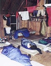
| A slow wakeup at Glencliff Hostel |
Our day’s big climb takes us over Mt Cube, starting with a gentle climb up to Brackett Creek, though here we enter the switchbacks winding endlessly upward in the afternoon heat. Our only relief is the Orange Gatorade we're trying in our tepid water - far more palatable than in past sections; but still it’s grueling, with me wringing out my bandana every few minutes in the small streams crossing our path just to mop my face with cool water. Coleen stops on a convenient log for a break, though I sense the top is near, and forge on. The radio and MP3 players ease it a bit, and finally we hit the south summit, covered with slabs of quartzite and a bit of a view, where we stop for a bit to chat with Jan Liteshoes, Chief, and Vic the Brit. We head on down, making slow progress on these slippery slabs (thank goodness they’re dry) and rocky trail, passing Grizzly and Pacman as the grade abates, and reaching the shelter trail at 5:20. It’s .3 miles up to the shelter, a long .3 at that, with the paperwork suggesting the only water is way down here at the AT, although on the way we’ll cross a couple of brooks that’ll suffice. One of them is right alongside the privy trail, making me wonder about its purity, but I’ll find later that the trails diverge, making it safe enough; and just across it is the shelter – a truly magnificent structure.
Designed by a Dartmouth architectural student, it’s hexagonal, with a huge natural trunk at its apex, and already occupied by a father and son, along with the elderly Amble, whose tent is set up in one side. Luckily, it’s an expansive space, with plenty of room for our gear in the back; and Coleen heads out to the brook immediately to bathe. Finding a large pool for a comfortable bath, she returns in semi-ecstasy, by which time I’ve staked out a sleeping space and got the gear out for dinner. Cooking becomes a small debacle as Coleen forgot the capacity of our cups, overfilling the water and needing to relight the stove a 2nd time – I chide her a bit more than necessary for these in light of our guests. As we have our typical noodles, Amble turns in early, promising to be up at first light. We’re about to turn in ourselves when two northbounders come up in the fading light – a couple who’d planned on stopping at the Firewarden’s cabin on Smarts Mt, but had been frightened by the sight of some bear scat around. He’d talked her into continuing, and she’s limping up to the shelter as if seriously hurt, whining and crying all the way. I’m thinking she’s in need of some aid, but after sitting for a few minutes she’s totally revived, coming back to our dark corner to ask Coleen where she’d found the bathing pool. They’re up for a bit getting settled and having dinner, preventing any sleep until 10:00. |
|
8/8 Hexacuba - Moose Mt Shelter (17.9 miles)
"In most men there lurks a lesser man, and his presence smells in the sun."
Ernest Gann – Fate is the Hunter
|
|
As predicted, Amble's up at an early 5:15, though we hadn't foreseen the din produced by his stowing his tent, having to pound out the stakes he placed in the shelter floor. There's no hope of sleeping through it, so we get around for an early start to our long day. Everyone we’d passed indicates we’ve a tougher trek over Mt Smart than Mt Cube yesterday, with a particularly tough descent, so we’re anxious to get going. We begin with a descent across a couple branches of Jacobs Creek, the first making us think momentarily we were making good progress. The south branch however (spanned by a another unique geometric bridge) confirms what a long day it'll be, our gentle but endless climb up Smarts Mt beginning immediately after. It quickly turns to a sea of mud, slowing us badly, and proving totally demoralizing. We slog through miles of the muck, sweating through the muggy climb without a single hint of a clear rivulet to wash out my reeking bandana. Finally we choose a marginal log for our am break, which I estimate to be another :50 from the top.
|
|
| The unusual and expansive Hexacuba Shelter |
We resume our climb, with a momentary reprieve in a small marshy area, surprised immediately after to come on on the Clark Pond Loop trail junction - how can this be? The map shows this follows the summit, with the Firewarden's Cabin a mere tenth mile down the road. As we're pondering this, we come across the cabin, realizing we'd been making far better time than expected, with the first summit going by unnoticed in on the shallow climb. This is great news, our big climb for the day being over; and we take a minute to peruse the cabin, wondering why the couple last night passed on it. It's a mystery to me, with no sign of the alleged bear scat they saw, and a fully-enclosed cabin to protect them even if - go figure. We resume the descent with renewed vigor, finding it steep and rocky, but not nearly so bad as we'd been led to believe. After a short steep section, it shallows nicely, continuing across the Lambert Ledges, a series of quartzite slabs with nice overlooks of the surrounding mountains. I take a moment to do some foot repair on one of them, sending Coleen on ahead, where I find her moments later chatting with Chuckles - a school teacher / section hiker who's trying to cover the White's this summer.
|
After a brief chat we forge ahead to the Lyme-Dorchester Road, where we'd been told there was a water tap for hiker use. Finding nothing similar, we filter water at the clear brook here, using a large rock for our lunch break. I soak my weary feet in the stream, putting my socks out in hopes of some drying, and a woman and her daughter pull into the parking lot to exercise their dog. We chat a few moments before noticing that their German Shephard (Cody) is peeing on Coleen’s pack, for which the woman’s extremely apologetic, scolding Cody mercilessly. We brush it off with a laugh, finishing our chores before pushing on, the fairly level trail taking us a couple miles through overgrown meadows before finally seeing the aforementioned water, although by now it’s of no use to us. During this traverse Coleen yips in pain as she takes a deer fly bite through one sock – a bite that typically causes her pain all afternoon, but leaves no mark. Reaching the 2nd crossing of Lyme-Dorchester Road we find a school bus waiting, and as we start our climb of Holts Ledge, we’ll see why – a large bevy of elementary school girls coming back from a field trip up here – they look very fresh on their way downhill, but it’ll be quite otherwise for us on the grueling climb.
It’s not terribly steep, but the 1200’ of climb in the muggy afternoon goes on endlessly, each of us sweating rivers, and even our tepid water isn’t very refreshing, our limited Gatorade stock now greatly diluted. Near the top, the passage of Trapper John Shelter (named for the fictional MASH Dartmouth grad) shows we’re making progress - finally we break out to the ledge itself, hearing a few peeps from the falcon chicks here (it’s a nesting site for peregrine falcons). Though we’re relieved to have some views from the ridge, it’s still a long and unexpected climb up to the unmarked summit. After a while we head back downhill through a beautiful spruce forest, passing another host of northbounder’s. Finally we reach Goose Pond Road, from which our final climb for the day is to begin; so we take one final break here on the trail steps at the roadside. We’re not at all looking forward to this final climb – the previous one was bad enough; but we forge ahead, climbing fairly steeply at first, but rounding the ridgeline to a more gradual climb after just a few minutes. Coleen’s got her MP3 player out to ease the pain, and it goes better than expected, winding through the woods until finally reaching the top. As the trail levels it’s generally pretty easy along the ridgeline (slowed by occasional muddy stretches, but with no water good enough for a potential camp site), and we count down the miles to our destination at the Moose Mt Shelter.
We’d heard that this was a small, dark, and dank shelter; and we’ve some worries about it being full (with no tent sites around), but suddenly we come upon the sign at an early 7:00 – we’ve done an amazing 2 mph since our last break, even with the day's late climb. We’re invigorated by this news and the end of our long day, but it’s still a long .3 down a rocky and muddy road to the shelter – a road obviously shared with horses as well. Our elation continues on finding the shelter empty – even though it’s small and with a low overhang, there’s plenty of room for us, and I fairly collapse onto the shelter floor as Coleen sets about finding the water source to clean up. It's not big enough for a bath, but at least she gets cleaned up a bit and starts tonight’s dinner (with scarce help from me), having a freeze-dried backpacking meal, to which she adds our last cup of noodles (amazing how much more she eats than I do out on the trail). After getting everything hung up and the hot drinks and dessert made, we retire for a leisurely evening, turning in at 9:45.
|
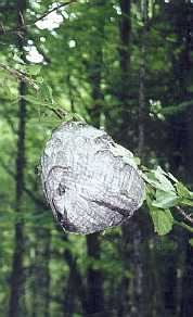
| A large and very active beehive right in the trail
|
|
| One of several beaver ponds as the rocky NH gives way to the pastoral VT |
|
8/9 Moose Mt - Hanover NH – Home (10.8 miles)
"True happiness comes from the joy of deeds well done, the zest of creating things new."
Antoine De Saint-Exupery
|
We're up with the first vestiges of light, and having run out of coffee, we make mocha from our remaining supplies (good), with our final breakfast as we make quick work in our dreary shelter of packing. After the .3 climb back to the trail, we're on the AT at an early 6:33, starting with the climb over the South Peak of Moose Mt - gradual enough that we're barely sweaty even on this muggy morning. The fog and cloud gradually thin, and soon we're into the featureless downhill, making good time, although it's weary work in this soupbowl. The Etna-Hanover Center Road is our halfway point, and we're besieged here by mosquitoes, stopping for an immediate DEET dousing and our break at a small creek immediately after. Even our good progress barely elevates our spirits, but with the end palpably close, we forge on, making good progress to Trescott Road, after which we've a couple of speed bumps to contend with. The first is mild, but just as we think we've gotten off easy comes a badly overgrown marshy area and thence begin the real popover - far more trying than expected. Just before reaching the top we pass a foursome of cleaned-up, fresh northbounder's coming from town who seem chatty. We share considerable info on the Whites with them and wish them well before returning to the trail, which soon starts a steep and rocky downhill. Several places are rocky enough that I wait for Coleen to get through, but finally it levels, and glory of glories - to our right is the athletic field that herald's town's coming. The trail emerges suddenly into the quaint and busy Hanover, and it's an instant time warp - we've just come forward a couple centuries to the real world, the noise of which is deafening.
We make our way in the hot sunshine down the streets of town, each seeming to be filled with college kids out exercising, and finally we get sight of the A Lot sign. There's the glorious sight of the Eclipse, and I'm immediately relieved to find it intact; leaving us to the prearranged plan - throwing the gear from the trunk into the back seat to make room for the packs, and myself taking the helm for a quick trip down to White River Jct for the post-hike pigout. One more section hike and we'll be ready for our appointment with Katahdin!!
|
|
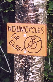
| A little humor from the Dartmouth Outing Club (the trail's quite rocky in this area) |
| |


