The End of the Beginning
¤
The journey never ends
Hanover NH to Danby, VT
On November 10, 1942 after British forces turned the Nazi tide at El Alamein, a stoic Winston Churchill addressed the nation with the words, "Now this is not the end - it is not even the beginning of the end; but it is, perhaps, the end of the beginning." So we approach our final section hike with a sense of accomplishment, but also with a bittersweet flavor - we eagerly await the race to Katahdin next month, and yet we'll miss these monthly treks, still a little unsure how to fill this gap in our hearts. Still, there's no lack of obstacles to confront - my Mother's been fighting some aging problems, and with a number of important medical tests scheduled in the midst of our hike, we make a last-minute schedule change to finish the hike beforehand. This will turn out to be providential indeed.
|
|
9/4 Hanover NH - West Hartford VT (9.8 miles)
""It is a mistake to look too far ahead. Only one link in the chain of destiny can be handled at a time."
Sir Winston Churchill
|
|
We'd originally planned this hike for next week, but with the aforementioned issues, we quickly threw it together for a hasty departure. It begins with our third and final time we drive into Hanover, parking in the familiar A lot again - this time to hike south on our one remaining section before the race to Katahdin in October. We mount up the packs and head for The Green, where there seems to be more than the usual activities about. At one of the sorority houses on the green there's loud music playing, a number of coeds dancing about out front in preparation for some sort of party tonight; and it seems it'd make a fitting pix for the beginning of our hike. As I pull out the Olympus however, it's dead as a doornail, and no amount of playing with the switch or the batteries will restore it. Bummer! Luckily we've got the Canon as a backup, so we pack up and head down to the CT river, where I decide I'd better try the Olympus one more time for a pix.
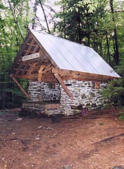
This time it works like a charm - go figure - and after a quick pix here we continue under the interstate and into the quaint New England town of Norwich. I'm musing to Coleen on how we should get someone to take a pix of the two of us hiking through when we realize we haven't seen one of the few blazes for a while. Just as we're looking around, a car pulls up, the driver singing, "You're off the trai--ll". He directs us back to Elm St, where it departs south out of town, crossing a beautiful gorge at the town's margin, followed by a collection of nice upscale homes on the roadwalk out of town. It's quite a climb, but easier on the pavement, with almost an hour since our departure before we finally diverge into the woods. It's easy trail, with our break at the beautiful Happy Hill Shelter, an almost-enclosed alpine stone shelter with an upper deck that'd be a nice stay, although we've miles to go.
|
|
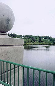
| The Connecticut River separates VT and NH - go figure? |
|
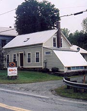
Following a short uphill over Griggs Mt we start down towards West Hartford, the noise from I89 driving away the forest's peace for miles about. We're really wondering how sleep can be possible at our destination, but surprisingly when we pass under the interstate it quiets quickly on the other side. We pass a number of rural homes before turning down the main street of town, and surprisingly early come upon the Hartford Sign Co. sign that announces our destination for the night. The house belongs to the brother of one of our good friends, with whom we'd arranged to stay here; and we'll find the owner Steve out working in his shop. Our friends have told us he'd keep us entertained with stories as long as we have time, and it's we'll immediately find this to be true, starting with stories of a beautiful Model T sitting here in his shop. With the trail going right in front of his house, he's let numerous hikers stay in the yard, and after catching up a bit, he asks if we'd like a room inside or to camp outside, and Coleen pops out the inside response without hesitation, at which time he shows us to the guest bedroom and bath.
They're good accommodations, although Steve quickly returns to his chores without with minimal guidance, so we unpack and dive into the shower, after which our next priority is food. We take over the kitchen, finding pots to cook a Lipton rice meal with a cup of noodles, which sates us fully (we're most happy to have ice water available). When Steve finally calls it a night in the shop, we'll find that Kathy is working a late shift, so we probably won't make contact with her. Still, Steve talks enough for them both, the subjects ranging from hikers, sailing, airplanes, our former lives, and a host of others, all of which Steve could talk for hours about. We're dying of fatigue, and we finally take our leave, retiring at 10:40.
9/5 West Hartford - Wintturi Shelter (16.4 miles)
"I think, said Cristopher Robin, "that we ought to eat all our provisions now,
so we won't have so much to carry."
A. A. Milne - Winnie the Pooh
It's a fair night's sleep, though interrupted by Kathy's arrival late, and a freight train roaring through the back yard in the wee hours. We're up at 6:00, having some of our camp fare for breakfast (what a rare treat to actually toast my pop-tarts), with Steve arriving soon after to make coffee. We have a leisurely morning talking Steve's PCT experiences some years ago and his busy day ahead, which finally impels him towards the shop. We get afoot at 8:04 with profuse thanks for the room, heading through the remainder of the small town, passing the popular Rick & Tina's deli, which already has a substantial customer base in attendance. The trail thence crosses the White River on an ancient and massive bridge, and thence turns quickly upwards into the hills surrounding town, several of which have beautiful meadows atop appearing from the morning mist.
|
The beautiful Happy Hill Shelter - love to stay, but we've even better accomodations waiting
|
| Our friend Steve's business
| |
|
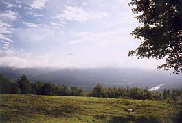
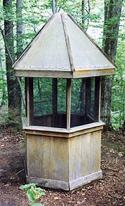
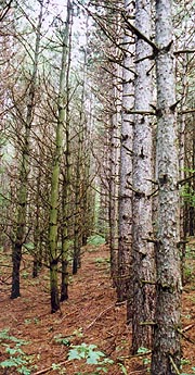
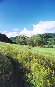
Shortly after we reach the first of these meadows in a golden morn as the scudding clouds break up to reveal the river valley below. It's an altogether pleasant morning as we wind through the pastoral countryside on easy trail, soon running into the tail end of the northbound throng of thru-hikers - in this case Bog Bridge Tester, Indiana Ben, and Yellowstone Man - all hurrying towards Katahdin to beat the winter snows. After traversing a beautiful red pine plantation we'll break at Thistle Hill Shelter - a couple tenths off the trail, but a must-see for its rare screened pentagonal privy featured in the 1967 National Geographic article on the AT. The easy trail continues across Cloudland Road, passing several fields where the forest to our right is roped off by large plastic-coated cables - we're still at a loss as to what these represent. There are a couple of open summits before we descend to Pomfret Road, one of which is occupied by a northbound couple lounge in the morning sun, their gear spread all over the hillside to air out, with little urge to move on. On the descent we run into a familiar face - it's Taba from our mid-VA section this summer, and we stop to catch up (he took a couple weeks off the trail to earn some cash, and is now planning on opening a bike shop on its completion), and over the next couple days we'll run into (and read in the registers) many we'd met in said section.
|
|
| The clouds break as we climb into these pastoral VT meadows |
|
We break at the road, traversing a few meadows before the afternoon takes us across a couple steep speedbumps (although small enough that we hardly notice), followed by the lengthy climb of Dana Hill. Though it looked easy on the profile, it drains us thoroughly, but finally we're over and into the descent, running into Sage, who's been into town at the upcoming VT 12, and who left sodas ahead for Puff Daddy and Bluebird (making sure we're aware of this in case we get there first). Coming down the hill we run into Bluebird, and immediately recall that these two were part of the soggy corps we hiked with in VA - the pair that passed on our last shelter there to avoid spending another night with Windsong, Trauma, and Yoni. After Vt 12 begins the day's final climb - the gentle but long climb up to Wintturi Shelter, and it proves quite sapping. Coleen lags considerably, and the easy, cushioned forest path we'd been hiking is replaced with rocks and roots - I'm sure we've slowed badly, but surprisingly we arrive a few minutes before expectations.
It's a couple tenths down to the shelter - a basic but large wood box, although it's clean, with a register showing no signs of mouse damage. There's a brook adjacent, and with an hour before dark I scout around for firewood - no easy chore, but not impossible either. Coleen bathes as I build the fire, and soon after we have our "heavy" meal - the tuna along with the Spanish Rice - excellent in all regards. It's a nice clear night with the half moon and Mars peeking through the trees as we sit around the fire, filling the night with a couple of hot drink rounds. As I'm building the fire, I almost step on a small mouse peering from under the benches, but he'll never reappear to bother us. It's chilly out, and we've all our spare clothes on as we retire, though I decide to check phone messages before we get to bed. I find as I do that there's a message from nurse Suzanne that Mom's had a relapse of her symptoms, having been sent up to St Mary's. I've got almost no reception here, so I have to stand on one of the benches as I start a series of calls, some of which disconnect, and some complicated by the typical hospital fog of misinformation. Tressa (Emg Room nurse) tells me Mom hasn't been admitted yet - "call back in :40", and when I finally do, I'll find her admitted, although it's a real bear to locate here. One such call finds my cousin Steve in the room, but gets cut off; and finally I get through to a male nurse who lets me through to her. She's pretty confused and anxious, although in good hands here, and insistent that we continue our hike. I tell her I'll call again tomorrow (though she's worried she'll be busy in tests all day), and finally we get to bed at 10:40 - long after we'd intended.
9/6 Wintturi Shelter- The Inn at Long Trail (19.9 miles)
"Why hurry headlong to thy fate, poor fool?"
Sophocles
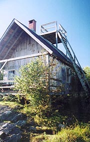
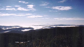
We're both a little cold to sleep well, waking at first light, my own sleep problems compounded by a crick in my neck when I tried to sleep on my side. It's our long day ahead, with numerous ups and downs, but at its end is the Inn at Long Trail, promising town food and a good bed, so we're anxious to get started. We're out at 6:50, with a few ups and downs before coming to the Lookout Spur trail - a .2 diversion we'd otherwise skip, but with the beautiful morning out we decide to have a look. We find a cabin lacking a view, but with a ladder to a platform on the steeply pitched roof, so I can't resist taking a peek, finding it well worth the effort. It's perfectly clear in all directions, with the valleys filled with fog - an excellent photo op.
Soon we're back to winding along the ridge past the pretty Lakota Lake lookout, stopping for our morning break at Chateauguay Road. The numerous ups and downs continue until the final descent to Mink Brook, from where the day's big climb up Quimby Mt is to begin. As we cross the brook Coleen takes a seat on a nearby rock sobbing, feeling disappointment in her inability to keep up. With a shelter just a little up the slope I convince her to continue, and we start the climb - not so bad as we'd thought. After a break at the Stony Brook shelter we resume the climb, soon topping Quimby, where the trail undulates along the ridge crest for several miles before the steep descent to the Ottauquechee River. From here its a road walk for the next couple miles as we climb out of the river basin, joined by a couple walking their dog up the road, although it's not long before the trail returns to the woods, soon to pass Kent Pond and join the Gifford State Park, where we're hoping to find a Coke machine (I’m purposely leaving our final break until then, although Coleen’s ready to stop ASAP).
|
| The classic Cloudland privy
|
 |
| A beautiful pine farm
|
|
| The odd Lookout Cabin with a commanding view from atop. |
|
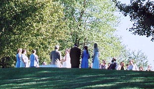
At the perimeter of Kent Pond, we traverse a clearing where a wedding’s being conducted, ourselves framed right behind the wedding party, a couple canoes on the bank festooned with cans and such to be their getaway vehicles. We're pretty out-of-place here, but it doesn’t stop me from a quick pix, the trail winding next around the shoreline, the map showing the park lies just at the SW corner of same. The trail takes a number of circuitous twists and turns (none of them well-blazed), taking far longer to circumnavigate than I would have thought, and the afternoon drags on as we slog around (though there are some beautiful views). Worse, we’re pummeled by the noise of traffic and numerous motorcycles, finding the source to be the very busy Vt 100, which we must cross to get to the park. Finally we’re at the park, although no Coke machine appears, and we wind up the road following the trail amongst the camping areas, stopping for our break at the first picnic tables we see.
A couple ladies are setting up for a large picnic here, and I decide to ask if they’ve any sodas for sale, although when I do, they look at me as though I’m from the moon – only now do I notice one of them has a rather long goatee. I also ask a group of guys playing croquet here the same, finding in the conversation that they’re decidedly gay, and as we’re packing up to head out the bearded women asks if we’re AT hikers, having thought us part of their gathering. We find it’s a jamboree (obviously a group embracing alternative sexual preferences), and one fellow there does offer some Diet Cokes’s from a cooler he’s been trying to get rid of. They’re a bit flat, but at least they’re cool, and after a brief chat we forge ahead towards normalcy, the trail climbing away from the park for our final climb towards the Inn at Long Trail.
|
|
| View from Lookout Cabin - the foggy morning valleys |
|
| If you have your wedding on the AT, expect some unsavory guests passing through. |
For reasons unknown, the AT has been relocated away from the Inn, requiring a lengthy circumnavigation, followed by a dangerous roadwalk to the Inn – so dangerous in fact that the AT guidebook suggests the safer route is the old AT – now blue-blazed as the Sherburne Pass Trail. With this relo, none of the mileages in our various info seem to agree, so we forge ahead in the climb, with very noisy traffic to our left, an uncertain path ahead, and full of fatigue from our already long day. Finally we come to the Old AT junction (this also used to be the fork of the AT and the Long Trail, which now has been moved further north with the relo), taking the Sherburne Pass trail the short half mile down to the Inn. It’s an exceedingly rocky path – reminiscent of NH in its difficulty. It does arrive at the promised land however – coming to the road right at the beautiful Inn at Long Trail, which is almost carved into the rock face behind it.
|
Within we’ll find a very hospitable hostess, giving us the expected $60 hiker rate (includes tax and breakfast), and finding us a quiet room away from the highway per our request. We’re eagerly looking forward to dinner, so we shower without delay, the room surprisingly nice for this type place (no tv or phone in the room, but one in the guest room downstairs), and soon we’re cleaned up and headed down to the pub for some needed town food. We order some bacon & cheese-covered potatoes as an appetizer (lame), with burgers to follow (good, but very rare), and a Long Trail Ale each to celebrate our 2000th mile - accomplished this very afternoon! It's a lot of food, but not a crumb is left, with room enough to share an order of the apple crisp with ice cream after. I’ve got fair cell reception here, putting in thank-you calls to cousin Steve and Virginia, followed by a call to Mom, finding her in good spirits, although a bit worried about the tests being conducted. We tire quickly, turning in happily at 10:00.
9/7 The Inn at Long Trail - Clarendon Gorge (17.5 miles)
"Health is the first muse, and sleep is the condition to produce it."
Ralph Waldo Emerson
We’re up at a surprisingly late 6:40 feeling totally revived, with just enough time to get packed and carry our packs downstairs in hopes of a quick getaway after the breakfast hour. We’ve just enough time as we wait to catch a little news and weather on tv, meeting fellow section-hiker Runaway, who’s done all the trail from GA to here, planning to end his section at Hanover. We find a table together, with a couple girls hiking the Long Trail taking the adjacent table and chatting over breakfast as well. Breakfast is quite filling and good, with ample coffee, and we savor it quite a while before finally hitting the trail at 8:34
I’m feeling totally invigorated on this crisp autumnal morning, Coleen a little less so, but even so we make good time on the climb up Pico Peak – well rested, well-fed, and well-watered. It’s a great day to be on the trail in spite of the substantial climbs and slightly rocky trail ahead, passing Pico Camp as a couple hikers depart, and stopping for the morning break at Cooper Lodge just below the Mt Killington summit. As we’re there, a number of day hikers come through, along with the flip-flopper Sun Dog, pushing south for a Harper’s Ferry Completion in October. We’ve seen enough vistas that we forego the side trip to the summit, continuing south on the AT as it winds down the Killington ridgeline, with occasional crossing of various ski trails. As we slab the side of Little Killington in the descent, there’s a short narrow segment that’s incredibly rocky and rough, but it’s only a few hundred yards before we return to normal VT trail, eventually descending to the Governor Clement Shelter – empty, but with the ashes of a fire still smoking in the fireplace (caution is recommended for stays here as it’s right on a road, with the expected use by the locals). The trail eases considerably, and we take our pm break at Upper Cold River Road, applying our daily DEET regimen as the mosquitoes converge on us once again.
|
|
| At last - the pastoral VT meadows |
|
| Our "town" night - the beautiful Inn at Long Trail |
We wind through the woodlands, passing a portly and scantily dressed hiker and her dog heading north who says there are numerous tentsites in Clarendon Gorge area, easing our minds about using this as a destination (our guidebook suggests camping is not allowed here). We push on, with Coleen lagging behind more and more, especially after I suggest she's out of shape. It’s fairly easy trail though, and atop Beacon Hill (site of an airport beacon) we begin the descent towards the gorge, which levels at the Clarendon Shelter. I’m a bit worried Coleen will look for me here when she catches up, so I wait until she’s within earshot to yell that I’m heading on to the gorge, and thence continue. The final descent from the hill is in a very steep and rocky gorge (preceded by an overlook with a stunning view of Rutland airport) that’s very reminiscent of the Maine trail – tricky enough that I wait until I can see Coleen descending it before continuing, with a small farm field at the bottom, followed by the busy VT 103 and the trail to Clarendon Gorge itself.
|
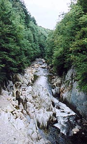
The precipitous gorge is crossed on a wobbly suspension bridge with a gorgeous view, and on the other side is a wonderfully level spruce grove perfect for camping – indeed there's a father and son with a fire built just to our left, and another solo tent a little further down the trail, occupied by Daddy Long-Legs, a previous AT hiker who’s doing the Long Trail now. We find a nice spot, and with a little work find sufficient firewood, by which time Coleen’s cleaned up and ready to start dinner. As we dine by the fire (with two rounds of hot drinks), we discuss her lagging pace, resulting in a spat over her general conditioning. A few sprinkles fall soon after, impelling an early move of equipment into the tent, although it quits quickly; and I decide to make an attempt to contact our shuttler Steve with news of our early arrival tomorrow. I climb a ways up the AT south of the bridge to get a signal (in my moccasins in the dark), getting Steve immediately, though I'll find he’s driving a charter before our shuttle, after which he probably won't even make our original 1600 time, much less the earlier one, but there’s little to be done about it now. We spread the coals, hang the bear-bag, and turn in at 10:00, although it’s surprisingly warm inside the tent, and we gradually strip away layers, not getting to sleep for some time.
|
| A beautiful gorge with abundant camping nearby
|
|
9/8 Clarendon Gorge - Danby VT (14.5 miles)
"Reach high, for stars lie hidden in your soul. Dream deep, for every dream precedes the goal."
Pamela Vaull Starr
|
I'm up a few minutes before our planned 6:00 wakeup, and seeing signs of life in Coleen I awake her as well at this point, with a quick packing job (complete with double coffee, thinking our filtered water might be a tad short today). We're up to the AT to start hiking at 7:05, with an immediate climb up out of the gorge, which Daddy Long-Legs had promised to provide a spectacular view. Unfortunately, it’s totally enshrouded in cloud this morning, and there’s little to see save the trail – even it’s a bit tougher to follow than imagined, coming to a fork in the trail that’s blazed on both forks (very confusing for a NOBO). As it winds around Spring Lake (where we’d considered camping last night), there’s no sight of the lake, neither is there a path that might get us water, so it’s a good thing we stopped when we did. Soon after we pass the Minerva Hinchey Shelter, after which there’s a significant relo to keep within the protected corridor – one that looks like it’ll steepen the trail considerably, although leaving the length similar. As we start around it, we’ll find it easier trail than imagined, though since the map hadn’t been so revised, we’ve little idea of our progress or profile.
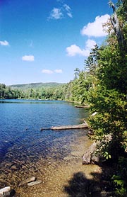
We descend to VT 140, finding a tiny bit of fall foliage about, and once there we’ll take our am break on the stairs of a bridge crossing the adjacent creek. Here begins the 1200’ climb up White Rocks Mt, reconnecting to the old AT near the Greenwall Shelter. At the summit trail we find a multitude of trail cairns erected, many of considerable complexity – one’s even a full arch. I try to catch some pix (by now there’s a brilliant blue sky out), but the background and cairns are so similar in texture, it’s tough to say how they’ll work. We resume our hike on the now rocky trail, stopping soon after the 2nd and final summit for our pm break on a convenient boulder. The trail eases after this, and soon we reach the Homer Stone Brook, crossed in a huge steel I-beam, after which the trail joins the shoreline of the beautiful Little Rock Pond. We’re expecting a shelter of the same name, but it appears to have been razed in favor of a tenting site and the Lula Tye Shelter shortly after, and we catch a few pix of the pond before leaving it to follow Little Black Branch stream, which takes us all the way to the trailhead at Danby Road. We reach the parking lot at 3:37 - early enough that I'm not sure we're in the right place. A quick recon confirms it though, and we each set about relaxing to wait on Steve, who says he's "35-40 minutes, max" out. It ends up being an hour before the big sedan pulls up, having to stop for gas on the way, but getting us back to our car just after 6:00 (talking about typical trail lore on the way, including his shuttle with the very drunk Uncle Johnny, a mason jar of shine in his hand as he drove).
It's a bit late to try the long drive home tonight, so we set up a hotel room at Windsor Locks, CT, a beautiful nearly-full moon rising in the east, with Mars immediately adjacent as we drive. It's a quick trip down, and finally we can breathe a real sigh of relief - everything is done up to our final race to the finish during our October vacation. Katahdin is now firmly in our sights!!
|
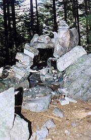
|
| Elaborate cairns built on White Rock Mt. |
|
| The beautiful Little Rock Pond |
| |


