The Race
¤
Which is not always to the swift, nor the battle to
the strong
Duncannon PA to
Port Clinton PA
Our peaceful home life is interrupted this month by my opportunity
to advance to the Captain's seat in a new aircraft, immersing me fully
in a mountain of manuals, schematics, and checklists. There is however
a short break between ground school and the tortuous simulator training;
and it seems a far better choice than toiling through my manuals.
We'll have to make some serious miles, but we can just fit in a nearby
section and get me back in time to head to the simulator (cramming in
typical college fashion on the way out). The race is on!
5/12/01 Duncannon PA - Peters Mt campsite (13.6 miles)
"There is a tide in the affairs of men,
which taken at the flood, leads on to fortune;
Omitted, all the voyage of their life
is bound in shallows and in miseries.
On such a full sea are we now afloat,
and we must take the current when it serves,
or lose our ventures."
William Shakespeare - Julius Ceasar
|
|
We're hiking this section northbound, so with one car left at Port Clinton we climb in the other, backtracking to
Duncannon, where PA welcomes us with its traditional rain. Lacking a good parking option we eventually head for
the dilapidated Doyle Hotel of AT fame (cheap beer and right on the trail). Here new owner Pat and his wife
welcome us to park in back, which looks marginally adequate, considering the possibilities of falling debris from
the hotel itself, or from one of its many inebriated patrons holding court on the balcony.
Afoot, we wind through the AT in town, reaching the west end of the Susquehanna Bridge at 1:20, starting across as
the rain starts to fall. With metal railings inches on each side of us, we're a lightning magnet here, so we
hurry on across without covering the packs. At the east bank the rain stops, and after crossing the busy highway
here the trail turns abruptly uphill through a series of switchbacks. Though starved, we defer lunch until
escaping the worst of the traffic noise, taking us well up the hill. The air is filled with the music of songbirds
and fragrant with the fresh smells of green plants after a spring rain; and the trail is soft and almost devoid of
the dreaded PA rocks.
|
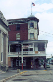 |
| The luxurious Doyle Hotel
|
At Clarks Ferry shelter a young man and 4 teen boys are roasting hot dogs over a roaring fire, but finding no
register, we return to the featureless ridgeline. Once across the blind and dangerous PA 225 intersection, we find
our first trail magic - a sack of apples and numerous water jugs here that come well-appreciated to us now. A
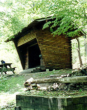
few overlooks penetrate the forest canopy, and soon we come to the Peters Mt shelter - an immense and beautiful
structure. It sports a full loft with stairs, and a protected picnic table downstairs with an awning that can be
pulled over the front window. We'd love to stay here, but with a schedule to meet, we drive on a couple more
miles. Just as we're packing up, I find a ring lying in the mud with an inscription of Chris' undying love for
Dave, so we're delayed a moment seeking an appropriate place for it.
We need at least 2 more miles for the day, so we resolve to walk until 8:00 before seeking a campsite, and quickly
lowering our standards as night falls. Entertained by the news from Lake Wobegone as dusk falls, our method works
in the typical fashion, finding an adequate site :20 later. There's a good tent site, with a sitting log adjacent
(with the blustery wind and the late hour, we don't feel much like a fire anyway). We dine on soup, sandwiches,
and hot tea, and chocolate for dessert, going through the usual buffoonery getting the bear bag hung, and turning
in at 11:00.
|
5/13 Peters Mt - Swatara SP campsite (18.4 miles)
"What saves
us is to take a step. It is always the same step, but we have to take it."
Antoine de Saint-Exupery
It's not a bad night for sleep, although Coleen's a bit warm in her 20F bag, and me a bit chilly in my 45F model.
We're up at 06:00 to a chorus of birdsong, out at 07:16, finding a clear but blustery morning out, the trees
around us creaking and groaning as we pass. We descend to PA 325, crossing the beautiful Clarks Creek, from where
the day's big climb up Stony Mt begins.
The namesake becomes obvious, with huge boulders as far as the eye can see both above, and equally far beneath us.
Only the trail is clear of these stones, and for once, we're thankful to its architects for our thin thread of
deliverance. Halfway up we pass an odd-looking woman plodding along - thru-hiker Oorah, having section-hiked half
the trail in 94 and 96, and allegedly doing its entirety now. It's tough to fathom looking at her, her enormous
gut replete with navel ring protruding over her spandex shorts; and panting like a dog even at her glacial pace.
Her comments are cryptic as well, with little sense of her location, and seeking a place to hitch into town for
"Pokey food", whatever that is. The next 7 miles of trail were used by the Dauphin-Pottsville stagecoach route
in the 1800's, which is absolutely phenomenal considering the number of rocks, trees, blowdowns, and other
obstructions to the trail. Walking's not bad, but a stagecoach must be VERY maneuverable - no way a jeep could
get through here. As we ponder this, we pass the first wildlife worthy of a picture - a 5' long pilot black snake
crawling across our path. This is a popular section for snakes, and though we'd really hoped for a rattler pix,
this will do for now. He slithers into the woods with his unique grace, and soon lunchtime comes on a convenient
log.
An interesting event during the pm break - Coleen's oft pondered about a tree falling on our tent some windy
night; and though I've always reassured her of the staggering odds against it, during our pm break one crashes
down with a mighty roar just to our right (I know, it conjures up the old philosophic saw). Timing is everything.
Our next concern is water - we've just crossed one stream badly polluted by mining operations, and piles of
mining tailings surround even the clearer ones. The trail winds to Rausch Gap Village - the remains of a defunct
mining village now full of bicyclists. We chat for a while on a stone arch bridge over Rausch Creek; and an odd
water purification device here - a tub-sized well of raw limestone through which the stream is diverted to reduce
its acidity. I'm sure it works, but downstream the stream bottom is full of white sediment and nothing seems to
be growing, so we won't filter here.
Haystack Creek meets our filtering criteria, so with full bottles we begin the day's last climb over Second Mt.
We're both weary, and our morale's low; not knowing where we'll spend the night, and disappointed by a possible
relo, which would both add mileage to our already long days and confound our navigation. Our fears prove true, as
atop Second Mt the smooth path descends straight down to the gap, while the AT diverts to the left up through a
field strewn with punishing rocks. We're bummed, but a passing section hiker confirms that a large meadow at the
entrance of Swatara SP should make for good camping. We find the promised meadow, nothing short of beautiful,
although it offers a few too many choices for camping. We walk around the meadow and woods seeking the
perfect site, but finally Coleen drops her gear, demanding an end to the search at a small campground nearby.
It's a little overused by the locals, with quite a bit of trash about and a privy that could collapse at any
minute, but there are a couple of picnic tables and a fire ring. Having been married long enough to know that some
battles aren't worth the fight, I yield, and she starts dinner as I roll a rusty steel fire ring over to the
picnic table to start a fire. It's a search to find wood, but eventually we relax over dinner as the evening
falls, turning in at 10:00.
| |
|
5/14 Swatara - Hertlein campsite (19.8 miles)
"May the
countryside and the gliding valley streams content me.
Lost to fame, let me love river and woodland."
Virgil - Eclogues
The songbirds awaken us again at 05:55 - it's a glorious morning, starting with a pastoral walk
through meadow and forest across the undeveloped Swatara Gap SP amongst the sweet smell of abundant honeysuckle.
Soon we walk on a beautifully manicured 20' wide swath of fresh grass of which the greenskeeper of any golf course
would be proud - I keep checking the blazes to make sure we're still on the AT, but eventually we're back to the
forest, with one more hill to climb before being exposed to the full din of the I-81 traffic. It's preceded by a
crossing of Swatara Creek on the historic Waterville Bridge - over a century old it's now relegated to foot travel
only, although I'd drive my car across without a 2nd thought.
Our road walk winds lazily under the busy I-81 overpass with widely spaced blazes, although on the other side we
only find the most faded of blazes well down the road, soon realizing we've been dealt a cruel hand. The trail
should have turned uphill long ago, so we backtrack to the I-81 bridge. Only after repeated searches do we find
the double-blaze, buried under a green marijuana leaf painted on the bridge piling by some errant teens.
|
|
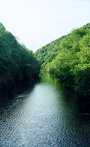
| A placid stream crossing |
|
Muttering curses under our breath, we turn our sights up the
steep hill, heading for the ridgetop where we find a familiar foursome. We'd passed them yesterday heading
southbound, only this time they've packs on. A woman of the group stops to ask me, "Are you unwired?", and as I
contemplate what this might mean, her husband explains that they're section hikers from Waynesboro, looking for
Unwired, who they'd met earlier on the trail (who must look similar to me, poor sap).
After our am break the signature PA rocks appear - in our last section, the snow masked their effects, and we'd
almost written them off. Now they're more contentious, joining the long days to turn our feet into hamburger.
Lunch is at the William Penn shelter (Coleen is annoyed at my referring to it as the Penn & Teller shelter),
another beautiful and spacious shelter where we dine barefoot, giving our burning feet a welcome rest.
After lunch the trail gets even rockier, the acrobatics of leaping from rock to rock becoming much more difficult
in the afternoon, especially as more and more of them have sharp jagged edges. Our pm break is at the 501
shelter, a rare enclosed shelter behind the caretaker's house where Klondike bars and sodas may be purchased when
he's in (beware of dog). He's out, but we peruse the register at length, finding most of our old friends have
stayed here - Caveman & Spike, Uncle Shoe & Doc Savage (Chili Mac must have dropped out), Jean & Comer, and many
more. It's good to read them and with some discolored, but safe water from the caretaker's tap, we're afoot.
Now the sky's turned gray, the wind's risen, and it's frigid out, looking as though it could rain or worse any
moment, so we bundle up as we start back down the trail. Now it's rockier than ever, and a couple guys we pass
confirm that it'll be so all the way to Shuberts Gap - the minimum distance we'd like to make for the night. We
take it slow climbing over and through the rocks, with a 2nd pm break atop Showers Steps - a beautiful overlook,
and by now the sky's clearing and it's warm again. At the Hertlein campsite we find a beautiful stream, with tent
platforms, good sitting logs and fire pits; so go in search of firewood - a formidable task indeed. We're both
pretty beat, and glad to turn in at 10:00, although before I finish my journal, Coleen's already snoring. Moments
later, I am as well.
|
|
|
|
5/15 Hertlein - Port Clinton - Duncannon (18.1 miles)
We have
not journeyed all this way across the centuries, across the oceans,
across the mountains, across the prairies,
because we are made of sugar candy.
Winston Churchill
|
| Our last day begins at 0605, and just over an hour later
we're climbing out of the gap. By the ridge line we're warmed up, soon reaching the Fort Dietrich Snyder monument
- just a small marker with no sign of the fort that had once sat here. It's quite underwhelming, and we're more
impressed by a small meadow we pass just after, its pines warming in the sun to mingle their fragrance with the
honeysuckles. We pass a group of two men and four teenage girls, finding they're the Roanoke Hiking Club on their
annual post-grad trip of 100 miles on the AT (what a boondoggle for the guys, both considerably older). Lunch is
a quick one just past Eagle's Nest shelter, and Rush Limbaugh keeps us company as the trail quickly becomes
featureless. We leapfrog a Game Lands road, but the trail architects insist on one last cruel joke, plunging us
right through the midst of a boulder field just within sight of the road we're paralleling. Our integrity intact
(though our IQ a matter of some doubt) we stick with the AT all the way across the tortuous rocks until it returns
across the smooth dirt road which smarter hikers undoubtedly used.
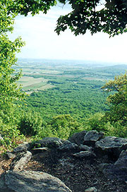
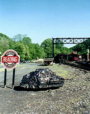
Finally we're descending, gently at first, but eventually turning steep, and then VERY steep, to the point of
concern. Still, we see the railroad yard where we wandered around lost in the rain at the beginning of our last
section, so it seems we snap a pix in this beautiful wx before heading over to our car and town food. We have
conquered the dreaded rocks and our fastest section to date, and now it's time for me to return to the rigors of
schooling.
|
|
| Finally we see the rail yard in the sun.
|
|


