The Agony and the Ecstasy
¤
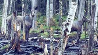
Found cohabitant in the mountains of Maine
Gorham NH to Rangeley ME
Once again, my good fortune at work allows me to advance to a newer plane, with all the requisite schooling and flight training. A gap between the two allows us abundant time for some of our longer remaining hikes, with Virginia and Maine vying for our schedule. The Maine section contains the feared Mahoosuc Notch - the "trail's hardest mile", a narrow gorge filled with boulders up to the size of houses; and all this in addition to the rugged Maine terrain with grueling hand-over-hand climbing. Yet time is a luxury we have at this point, something that'll come in handy should this section live up to all expectations.
|
|
5/20 Gorham - Success Mt campsite (13 miles)
"He knew that we gave constant lip service to the dictates of safety and howled like Christians condemned to the arena if any compromise were made of it. He knew we were seekers after ease, suspicious, egotistic, and stubborn to a fault. He also knew that none of us would have continued our careers unless we had always been, and still were, helpless before this opportunity to take a chance."
Ernest K. Gann – Fate is the Hunter
|
|
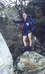
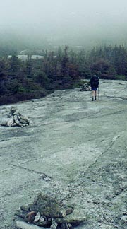
All the omens scream, "Stop, turn around, head back to Virginia" - a blown tire on the drive up, a major accident shutting down the road into Gorham, and finally, a trail report last night showing Mahoosuc Notch as impassable in deep snow. We've agonized over these last night before turning in, and we'll spend an hour or so this morning trying to find anyone knowing the condition of the Notch or alternative ways around should it be blocked on arrival. No one knows a thing - not the hikers, not the rangers, not the hostels - no one. Still, we're here, and with a trail that would allow an abort from the Notch if impassable (and an unseasonable heat wave up here), we're content to give it a try, loading up after breakfast at Hiker's Paradise, with Mary Ann taking us to the trailhead.
|

|
| One of many omens suggesting we take our hike elsewhere |
|
She tells us of New Year's trips on snowshoes through the Notch, brimming with hard-packed snow to make it into an easy walk (it'll be otherwise tomorrow, though). We're off at 9:22, the trail beginning easily enough, although the day quickly turns steamy as we head uphill on an old jeep trail. As it steepens Coleen comments on the lack of blazes, and it's soon obvious that the trail's parted company with us some time ago. The map shows the blue-blaze from town and the AT converge atop Mt Hayes to our west, so we take up a westward course up the mountain as the trail peeters out, assured of hitting one or the other. With the sun directly to our backs we bushwack, examining each animal trail we cross to see if it's the AT, but without success. The bushwack becomes more and more difficult as the forest fills in, all the open areas being filled with berry bushes festooned with thorns (they don't leave visible marks now, but our legs will look ghastly later). It's tough work, and Coleen can be heard praying for a return to the trail behind me as we hack our way through it all.
Finally the plan works and relief comes - here's the wide, well-cleared trail crossing our path! We're so spent that we take a break at the first log, having learned a valuable lesson about the difficulties of bushwacking. By our lunch stop our strength and pace are flagging badly in the afternoon heat, which shows an incredible 86F on my thermometer (it's only to top out around 65 back home in DC). Obviously our goal of making Carlo Col Lean-to is overly ambitious, especially as Coleen lags well behind; and as we stop at Page Pond to replenish our rapidly disappearing water supply, we consider our options as we swat away the numerous mosquitoes. We've got to get almost to Mt Success to make it through Mahoosuc Notch tomorrow, so we plan towards camping at its base.
|
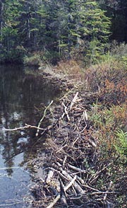
| The AT traverses Page Pond on this precarious beaver dam. |
|
Our spirits are lifted by passing a couple Southbounders in from Grafton Notch, who made it through Mahoosuc Notch yesterday, the hard-packed snow proving treacherous in spots, but passable with some caution. Passing Dream Lake we search in earnest for moose, but the only wildlife we've seen is a brown snake during our bushwack and several Spruce Grouse, a dim-witted bird that'll barely walk off the trail to avoid getting trodden upon). In this heat, we decide to have the turkey from tonight's sandwiches for a quick snack lest it spoil, and soon we pass the Gentian Creek campsite to begin today's final climb of a Mt Success precursor. After the jumpover we look in earnest for tent sites, finding one surprisingly good one immediately atop the shoulder. We look a tad further but return to this one, atop a good flat stone platform, comfortably off the trail. The mosquitoes are out as I set up the tent, but in the cooling evening our jackets provide plenty of protection as we have our bread and some chips for a quick snack. We relax from the day's travails, thinking about tomorrow's challenges as we turn in early at 9:45.
5/21 Success Mt - Mahoosuc Notch campsite (11 miles)
"What the caterpillar calls the end of the world, the master calls a butterfly."
Richard Bach - Illusions
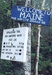
It's D-Day - time to exorcise the demon, the dreaded Mahoosuc Notch lying firmly in our path, and not only that; at the end of a tough 10 miles. There's a palpable sense that this is the make-or-break point of the trip, with today's activities setting the course for our entire week. Getting around at first light, the few cirrus clouds overhead take on a soft pink glow in the dawn sunlight ("Red sky at morning, sailors take warning"??), and we have the usual breakfast fare, though we find Coleen forgot the coffee, so we'll have to settle for decaf from the evening supplies (ugh). We're out at an early 6:05 as the skies immediately cloud over, a light and continuous rain beginning soon after. It's a tough day from the get-go, with poor blazing on the trail all day, and a windy and cold summit of Mt Success. Coming down the back side, the ME / NH state line provides a needed navigation fix, although the sign ("Maine - the way life should be".) fails to impress us much today.
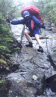
Above and beyond the cold, wind, and rain; the trail today seems filled with boulder scrambles, as if to prepare us for the Notch tonight, slowing our progress considerably climbing over these treacherously wet obstacles. We break at Carlo Col Lean-to for a respite from the rain, disappointed to find too late that it's a rocky and looonnngg .3 downhill from the AT. We filter water here, but on doing the math find we're going to have to pick up the pace to safely make the Notch by 4:30, which I consider the cut-off for safe passage. We scurry down the trail, climbing over Mt Carlo before the longer climb up Goose Eye, the summits of which remain solidly encased in cloud. We're trying to make up some time as we come off the peaks, with a series of puncheons taking us across the bogs following. Here the next calamity strikes, as Coleen's foot slides off one puncheon into the gap between them, her leg sinking into the muck up to knee level. She yells out, trapped so badly that it'll require both of us to pull her leg out - luckily her boot comes with it, but it's not a pretty sight, covered with some pretty smelly slop. She's unhurt though, and the clouds begin to rise above the peaks as we take our break at Full Goose Lean-to, back on schedule for the Notch.
We'll descend to it's west end of at 4:40, finding it a little underwhelming at first, and far different from our expectations. A 1000'-deep chasm between steep cliffs, it's said to be filled with house-sized boulders requiring exceptional effort to traverse, but from here it's barely more difficult than what we've come through, save being filled with snow to perhaps waist-deep level. This changes soon enough as we start through, the forested slopes on either side quickly giving way to sheer cliffs, as the car and bus-sized boulders are soon replaced by semi and house-sized ones. The tracks of yesterday's hikers are evident on the snow, initially seeming the best path through, and generally allowing us to gingerly walk over the snow, breaking through only occasionally. In some places the boulders rise above the snow so as to make it irrelevant, and we climb over, under, and through them as if in summer. In some places, we cruise easily over the snow as much as 10'-15' above the rocky floor underneath, but in others the snow disguises perilous ice caves underneath, which could easily plunge us through into the icy waters beneath with little hope for an easy rescue. Every few steps require careful planning, as some of the blazed routes are now impassable, requiring creative alternatives. At least the skies start to gradually lighten, with slivers of sun appearing before the mile’s end.
We end up having to remove our packs twice to crawl under immense boulders, and we fall through the snow and ice to thigh-level countless times. Without any doubt, it's the toughest mile of the trail, probably worsened slightly by the snow; and as the sun wanes towards the horizon, we keep thinking we're at its end, only to be confronted by some new obstacle. We're beaten and bruised, but finally the boulders give way to forest, and the stream even disappears for a bit. We'd expected a sign announcing the east end and a campsite of which we've heard, but there's none to be found, and suddenly the trail turns left and heads uphill towards Mahoosuc Arm. We're sure we don't want to head up the Arm though, so we drop packs and set about a search up and down the stream looking for a camping area. The pickings are pretty slim, with Coleen finding one fairly level spot, though very marshy with no sitting logs, and a small rodent running under an adjacent log as we’re looking about. As darkness falls I search in vain for a better one as Coleen rests, but finally this appears the best choice, setting up camp at a late 9:00. As we're cooking our noodles, a thrashing in one of the plastic grocery bags encourages a scream from Coleen. It’s our mouse, who can’t get out, thrashing around furiously until I go over to dispatch him, finally escaping into the brush, never to return. Our tent site is marginal, but we’re beat, so after hanging the "bear" bag we retreat quickly, though as we’re getting settled, we hear what sounds like a rifle shot. It’s immediately followed by the sounds of falling rock, so it must be one more of these immense boulders breaking loose; and after this poignant reminder of our day's achievement, we fall sound asleep at 10:40.
|
|
| A good example of the Maine perspective vice New Hampshire's |
|
| We always seem to be climbing or descending this section. |
|
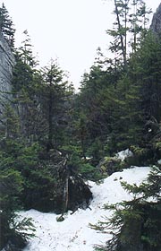
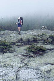
| The feared "Mahoosuc Notch" - looks innocuous from here. |
|
| Now we're getting into more serious stuff |
|
5/22 Mahoosuc Notch – Baldpate Lean-to (9.4 miles)
"Never put off until tomorrow that which can be done the day after tomorrow."
Mark Twain
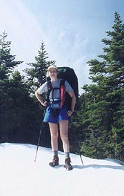
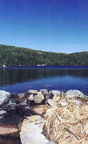
In spite of the irregular ground, we sleep the sleep of the dead; yet the morning sun finds us still unrefreshed after yesterday's ordeal, getting around slowly for a late 7:22 departure. Our day begins with the steep climb of Mahoosuc Arm, said by some to be tougher than the Notch, and we’re glad to be doing it in the morning. It’s tough indeed, with many of the signature boulder traverses we’d grown to hate yesterday, and several steep hand-over-hand climbs as well. At least the weather’s cleared, with moderate temperatures, and after topping the Arm, we make descend through occasional snowbanks towards the beautiful Speck Pond, stopping at the outlet stream for our morning break. I take a few pix on the snowbanks coming in as well as of this beautiful alpine pond, but we have to push on, passing the campsite as we begin the day’s big climb of Old Speck, looming ominously ahead. Other than the occasional snowbanks (a slight bother, as our boots are still soaked from the Notch), it’s a nice alpine climb, though when we finally get to the fire tower, we can’t find the trail outbound anywhere, despite considerable searching.
Finally a close search of the map reveals the AT turned off downhill before the tower, and that we’ve actually been on a blue-blazed trail for the .3 mile since this point. Damn these trail-blazers! In this bastard step-child of a trail section, the AMC from NH are in charge of trail maintenance even though we’re in Maine, and their lack of dedication to the AT is clearly evident. They virtually refuse to use the monikers “AT” or “Appalachian” on their signs, and white blazes are almost nonexistent. We retreat to the intersection, again having to study sign and map for some time to know which way to proceed; having lost a precious :40 of our day. The descent is long and steep, with lunch part way down, but with Coleen lagging considerably as we continue. By the time we reach Grafton Notch at the bottom, we’re running very late, placing in jeopardy the remainder of our schedule. I’d hoped to make it to Frye Notch Lean-to tonight, thence South Arm Rd tomorrow, allowing us to spend our final two nights in town, with a possible slackpack both days as well. We’re both slowing considerably, and my feet hurt badly in the usual places; making the idea of a couple of town nights and a slackpack pretty appealing. Still, we'll climb as far as Baldpate Lean-to, and based on how this goes we'll decide whether or not to continue to Frye Notch.
It's an arduous climb indeed - my feet are aching, but I’m totally zoned in on the climb – one foot in front of the other, almost dizzyingly olivious to the outside world. It won't be fun should we decide to continue on tonight, neither will it be entirely in daylight, our current pace putting us in there around 8:30 or even later. Still, we have picked it up to a solid 1.5 mph, and the terrain levels out soon, easing the pain and work considerably. Finally we reach the shelter trail, finding the lean-to itself a long 100 yards up the trail, and surprisingly, occupied by a couple we’ll find to be Lori and Dave. I could force myself on to Frye Notch, though frankly I’m relieved to hear that Coleen wants to stop now, even at the cost of no town night and no slacking.
|
| Still some snow up high to contend with. |
|
| Speck Pond provides a beautiful place for a break. |
|
We drop our gear and meet our hosts, who met on the Long Trail in 96 and are section-hiking the AT like ourselves. They’re also considering pushing on, although Lori soon decides to stay here, so we all set about the affairs of making camp, with yet another girl hiking in soon after (an admissions clerk at Yale). We all go to work on dinner, with the evening spent sharing tales of the AT and food (a common AT topic of discussion), having experienced many of the same hikes, and with very similar perspectives on life. It’s a good time, and everyone turns in around 8:45, ourselves following shortly after.
5/23 Baldpate – East B Hill Road (The Cabin) (8 miles)
"Some folk want their luck buttered."
Thomas Hardy - The Mayor of Casterbridge
The birds are around and singing by 4:30, and I can hear Dave and Lori getting up and around as well, although I manage to roll over and snooze a bit. They're being politely quiet, but they're out pretty quick (no breakfast), leaving the three of us to a more relaxed departure. Coleen and I are out soon after, launching immediately into the climb of West Bald Pate Mt - a tough climb in several places, but topping out quickly on the fog-enshrouded summit. There's a steep descent from here, but now that we're in MATC trail maintenance, there are a number of ladders, steps, and iron rungs for our aid - wish I could take some back to Mahoosuc Arm!! The trail levels slightly onto the broad sheets of granite that must give the mountain its namesake, and us some easy walking for a change. The sky clears as we round out in the col to begin the climb of East Bald Pate - an exposed crag of rock looming ominously ahead. It actually looks fun until we start the climb, finding it far more grueling than it appeared from afar. It's a series of sloping rock ledges, each one a healthy climb up to the next, and all of them sloping steeply right to the apex.
We're out of breath all the way to the top, clearing to a the panoramic view of the lake country before the steep climb back down to the Frye Notch Lean-to for our am break. Next, there's a short hop over Surplus Mt before starting the long but gentle descent to Dunn Notch, the sun warming it out until the black flies emerge. It's clouding over by the time we approach the notch, preceded by a mighty waterfall, though the dull skies don't present much of a photo opportunity. We're filtering water here, and as we discuss how much, Coleen suggests she'd rather hitch into town from here to call it a day. I initially dismiss this due to the early hour, but after a little math, I conclude we’ll only finish up a few hours later on Monday, with a huge increase in our comfort for a little extra cash. But is it cheating? Perhaps to some, but it meets the ATC definition, and there’s no extra prize for doing this the hard way vice the easy way. Besides, with the insects coming out, our gear wet and the forecast for almost continuous rain every day hence, the tough sections ahead, and our foot problems; I’m sold. Coleen’s elated as I call from the cell to see if the folks at “The Cabin” in Andover - Marge answers the phone initially, but I hear Earl pick up as well, with a hearty “You betcha!” to my request, agreeing to meet us at the nearby East B Hill Road in :40.
|
|
| Coming down from West Baldpate |
|
| And heading back up into the clouds on East Baldpate |
|
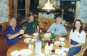
Coleen finds a renewed sense of purpose during the short climb up to the road with an easy rock-hop across the Ellis River, the van pulling up just as we're mid-stream. The gray-bearded Earl climbs out, extending his hospitality and talking us through a short history lesson as we cruise towards town. He asks if we need anything from the General Store, and we continue out to The Cabin – 3 miles past town in East Andover. It’s a nice-looking house, and Earl backs into the drive, insisting that he and Jamie carry our packs inside. Jamie's a thru-hiker (Mr Clean 96) whom Earl and Margie took a liking to, allowing him to stay and help run the place in between his various wanderings; currently engaged in mushroom collection for profit and hopes of finding a Lyme disease cure. Marge extends a hearty welcome as we enter, with an equal welcome from their enthusiastic dog Sheba. Marge's bought some wine, so we indulge, and are shown up to our room (we’re treated to the upstairs bedroom across from Earl and Marge, the hostel not yet totally cleaned out), where our priority includes a quick unpack and showers. Once presentable, we head back downstairs, where Earl makes some popcorn to tide us over as I get on his computer to check email. The computer’s glacial in speed, but eventually I get my mail, returning to join everyone for a chat as we await dinner.
Everyone seems to be recovering from the “cabin fever” of the winter – they're anxious to converse (in spite of having just returned from Trail Days yesterday), and it’s a good time for all, with the hearty dinner aromas soon drifting out of the kitchen. It’s quite a meal, with salmon, mashed potatoes, fiddlehead ferns Jamie’s picked, and a few other veggies, salad, and bread – all topped off with Margie’s brownies and ice cream. We’ll find this to be the norm here, with pictures of hikers eating lobster at this same table. Afterwards we retire to the living room to chat some more around the wood stove, finally turning in to our room to catch up on a little tv as we adjust the ventilation (it’s a bit stuffy up here initially), turning in at 10:30. This is just too easy – we don’t live this well at home!!
|
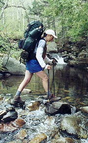
| Much easier rock-hopping than fording
|
|
5/24 East B Hill Rd – South Arm Road (The Cabin) (10.1 miles)
"He who would travel happily must travel light."
Antoine de Saint Exupery - Wind, Sand, and Stars
|
|
We’re up early to the smells of coffee and bacon, heading down to grab some coffee as we dress, with all the delights of home life as we get up and around to the typically hearty breakfast – blueberry pancakes, fried potatoes, bacon, eggs (cooked ourselves), freshly squeezed OJ, and the usual trimmings. We’re filled to brimming as we load up and head out about 8:00, Earl dropping us at the rainy trailhead as he suggests we’ll be done in 6 hours, although I consider 7 a better estimate, agreeing to a 4:00 pickup. We fairly well fly up the easy trail with our light packs, reveling in our fortune to slack the section, which excites Coleen considerably. We’re almost back at our effortless 2 mph as we pass a very foggy Surplus Pond, a small cabin faintly visible on the opposite bank, but alas, still no moose to be seen.
|
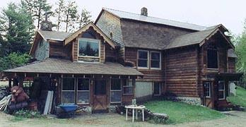
| "The Cabin" in Andover - everything a Maine cabin should be and much, much more
|
|
It’s an easy forest path climbing over Wyman Mt, then descending to stop at the Hall Mt Lean-to for today’s break to get out of the rain for our snack. We’re brought our cheese and crackers along with Marge’s brownies, although we chill quickly in our wet clothes; so we're back afoot with a steep downhill to Sawyer Brook. Again we’re able to rock-hop the brook, after which starts the steep climb of Moody Mt – our big challenge for the day. It’s very steep, with some hand-over-hand climbing required; but at our light weights we reach the foggy summit quickly. We stop momentarily at a grassy overlook to take a pix as the skies start to clear a bit, and I put through a call on the cell phone to Marge and Earl, finding Earl’s already headed out for the trail. The downhill is far more moderate than the climb had been, reaching Black Brook at the bottom with Earl waiting on the opposite bank. It looks like a long way between a couple of the boulders in midstream, but Earl waves us on across, and sure enough – it’s an easy jump between them. Our easy day is over, and we head back to the Cabin, reporting the few inconsequential blowdowns to Earl.
He suggests this might be a good time to get our car from Gorham, (which will allow him to watch sports tomorrow for the big Memorial Day Sunday), so I clean up and we head out (about an hour’s trip each way), leaving the girls to make dinner and chat. We chat much of the way about my job, and soon we’re back at Hiker’s Paradise, getting the car easily enough, following Earl back just in time for dinner. A little wine mellows the evening, with chicken breasts as the main course, and more of the same fare as before. The dessert’s a strawberry-rhubarb pie with ice cream, and we retire to the fire for a little conversation, with Earl turning in early (he’s up at 4:30 to make breakfast). With the car and our supplies here, I’m able to use the laptop to get email and start on the journal, turning in at 10:30.
|
|
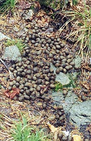
| A constant reminder of the moose in hiding |
|
5/25 South Arm – ME Rt 17 (The Cabin) (13.3 miles)
"The sleep of a laboring man is sweet, whether he eat little or much."
Ecclesiastes 5:12
|
|
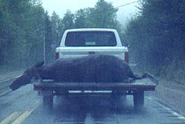
We rise at 5:30 as the aromas of breakfast waft our way, with today’s plan calling for a spot of our car at ME 17 before Earl drops us at South Arm. It’s another dreary day, but inspired by another hearty breakfast we shove off, Coleen riding with Earl and me following in the Eclipse. As we drive up, Earl suddenly pulls over, spotting a pair of moose in the adjacent stomp. He waits as I run across and take a quick pix (they’re far more skittish than I’d imagined), and we resume our course, although soon there’s another pull-over. This time it’s to let me ahead to see a huge moose carted on a trailer – obviously a road kill. Suddenly Earl does a 180 onto the opposite shoulder, where I find that this precarious perch is our parking spot – a spot that would have a gorgeous overlook of Mooselookmequntic Lake were it not for the cloud that now engulfs us. Not a great place to leave a car, but acceptable for a day hike; so I lock up and we head for South Arm, Earl taking us via some back roads that can only be safely traversed with his 4WD pickup. It’s a rough ride, but soon we’re there, Old Blue and our 13 mile hike looming ahead.
We’d expected this to be the hardest of the slack days, and Old Blue doesn’t disappoint, with a tough climb from the outset, a short moderate section, and another toughie towards the top. We begin at 9:31, climbing in our T-shirts and shorts despite the spotty rain, drizzle, and 50F temps; and soon our sweat’s mingled with the raindrops. After about 800’ of climb there’s a nice break in the middle though, with a much easier climb before the final 600’ push to the peak. It’s a relief to finish our final tough climb for the section, although the trail is still tightly constrained by the krummholtz and scrub brush to a narrow trench, often muddy and filled with water. The numerous exposed tree roots make it a little tougher, and the numerous blowdowns even moreso, counting 23 of the latter before we get to the Bemis Stream Trail. We’re mostly in the woods here – just as well as the few viewpoints are worthless in this weather anyway, and soon we’re doing a gradual climb over the side of Elephant Mt (first time I can remember slabbing a mountain this section vice a charge straight over the apex). There’s little of interest here save a section of trail filled everywhere with moose nuggets – even in this massive dumping ground we don’t see any moose, only their remains. We similarly hop over Bemis Mt, and thence down to the Lean-to for our break, calling the Cabin as we do to suggest not to wait dinner on us.
|
| Finally - two moose standing long enough for a photo - barely |
|
| And another who stood around too long
|
|
The final 4.6 miles of the day are a fairly gradual descent, punctuated by large wet inclined slabs of granite that seem more slippery than previous examples, slowing Coleen to a virtual crawl (and we’re tantalizingly close, the car sometimes visible across the valley). I go a few yards and wait, a few more and wait, etc, etc, etc, for the entire time, with the process worsening on the steeper final mile (I sure don’t want to rush her at the risk of a fall). Finally it levels a bit just before Bemis Stream, by which time the rain’s stopped, and the clouds are even trying to break up. This is our final “ford” for the section, and it’ll turn into the only one we can’t rock-hop. There’s a logjam to our left, and some more rock options to the left, but it appears we can make it, so we head across the scattered rocks ahead, getting about ľ of the way across before we run out of options. With only another mile to the car though (and seriously soaked boots and socks already), we decide to dive in for the final bit, squishing our way up the final climb back to our car. It’s a tough climb, but it keeps us warm in spite of our icy boots, with the sun peeking through on the way up.
We’re back to the car a little earlier than expected, with a quick trip back to the Cabin – so much so that we decide to take the time to fill up the car for tomorrow. We head past the cabin in search of the gas station but never find it; although we do get some pix of the covered bridge and a nearby herd of scrawny buffalo we’re surprised to see. When we get back to the Cabin, we find that Margie’s just gotten back from her family gathering, so they’ve waited for us with dinner, allowing us a quick shower before joining them for the pot roast. Margie’d been down at a family reunion, so Earl was in charge of monitoring the crock pot, with an excellent pot roast ready by this time. Jamie’s out elsewhere, but there’s no lack of conversation – so much so that even after Earl retires, we’re up with Margie for a while, not getting to bed until 11:15.
|
|
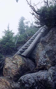
| On the AT, we don't see this kind of help unless it's absolutely necessary. |
5/26 ME Rt 17 – ME Rt 4 (The Cabin) (13.1 miles)
"It was the best of times, it was the worst of times, it was the age of wisdom,
it was the age of foolishness, it was the epoch of belief, it was the epoch of
incredulity, it was the season of Light, it was the season of Darkness, it was
the spring of hope, it was the winter of despair."
Charles Dickens –A Tale of Two Cities
|
Sheba awakens us with some barking early, although I manage to get back to sleep until 5:20, with breakfast well under way as typical. It's our usual hearty fare, and soon after Earl suggests we push on, taking the familiar drive up to the Rt 17 trailhead to leave the Eclipse, taking the pickup again over some slightly better backroads today over to the Rt 4 trailhead - a quick trip over, dropped off and ready to hike at 8:19.
We start a gradual climb southbound on the easy but featureless trail, taking us past a series of ponds we're counting as one last chance for our moose photos, making a solid 2 mph pace. Almost immediately we climb into the cloud deck, a light sprinkle beginning, which will intensify throughout the day. The ponds and marshes are eerily pretty in the fog, but the moose continue to elude us, with a midday break for some leftover cantaloupe, and our final break at the Sabbath Pond shelter. There's a small tent by the water's edge, and continuing up to the lean-to where we meet John and Zac, a Baptist youth leader and graduating HS senior (home-schooled), out on an overnight. They're nice guys with many questions about the AT, the shelters, and such; but after our simple lunch (small sandwiches made of leftover chicken and biscuits), we're eager to resume the trek. Even the moose nuggets diminish from here, and our May adventure finishes as predicted by 4:00.
looming ahead.
A stop by the General Store finds us some wine, and moments later we're cleaning up for the last time the wonderful aroma of spaghetti and apple crisp fills the Cabin. We decide our diets can wait one more day and afterwards we finish up with more than ample apple crisp and ice cream. The Merlot softens the mood, and we can't help but reflect on our fate. A few short days ago we were fighting the toughest of the tough, climbing hand-over-hand up sheer rock faces and falling through the ice crust into waist-deep snow in the Notch. Now we're relaxing in the lap of luxury in front of a warm fire with a superlative meal and a nice Merlot. This is the AT we've come to love - "the worst of times, the best of times".
|
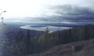
| A beautiful view of Mooselookmeguntic (no kidding) Lake from the trailhead |
|
| The "best of times" at The Cabin
|
|


