A Nemesis Defeated
¤
As others lie in wait
Pearisburg VA - Daleville VA
It's been three months since our aborted December hike, and four since we've completed a section; much having transpired since. Coleen's been under the knife for torn meniscii in both knees, and I've spent almost all of my waking hours (and some of my non-waking ones) moving troops and equipment east in support of the Iraqi liberation. We're eager to return to to our hike, especially as Katahdin looms tantalizingly close, a mere 6 hikes hence.
We've about 220 miles left in VA, with the remainder of our incomplete miles in the snowbound northernmost states of VT, NH, and ME. This is a "no-brainer", so we set a course for Pearisburg VA, thence to hike northeast in an arc around Roanoke. My schedule remains a bit tenuous, so we'll leave our shuttle for the tail end of the trip, to lend some flexibility in our total distance. So, after my arrival back from the east, it's time to load up the packs and get to it!
|
|
3/18 Pearisburg – Dickinson Gap (14.7 miles)
"What is our aim? Victory, victory at all costs, victory in spite of all terror;
Victory however long and hard the road may be."
Sir Winston Churchill
|
|
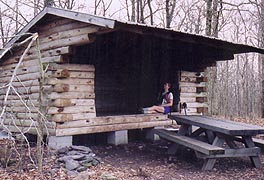
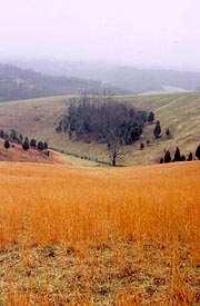
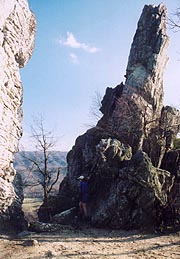
It’s a cloudy drive down, stopping at the Pizza Hut in Pearisburg for a final pig-out at the buffet, and thence on to the Rendezvous Motel where we’re to park the car. With a little work we find Buck, who knows nothing about our arranged shuttle, but directs us to an adjacent field to leave our car. We load up and start with a typical bound over some local hills towards the Senator Shumate Memorial Bridge, recently upgraded with a protected pedestrian footpath on either side. Once we've crossed the surging river (a mighty freight train soaring beneath as we do), our climb up Peters Mt begins on the opposite bank. Though well-graded and easy, we’re sweating profusely on this 60 ° day, longing for those cooler days we so love for hiking. We stop halfway up the mountain for Coleen to do a blister repair, and soon after we’re over the crest, reveling in the easy and smooth trail which traces the VA / WV border. Our first break at Rice Field Shelter is immediately preceded by a beautiful alpine meadow that inspires me to take some pictures, though the beauty is slightly marred by someone on the trail ahead leaving piles of orange peelings at every scenic vista, as well as the shelter itself.
|
|
| A quick rest at Rice Field. |
|
A mile or so further down the trail we find the source – thru-hiker "Happy", who allegedly started Jan 1 at Springer and now sports a huge ˝-gallon bottle of sour mash (we’ve anticipated him from his previous register entry in broken English). He’s stopped here at a spring with Tadpole (1/14 start at Springer) and Twinkletoes, a tiny toy-dog (perhaps a Shi Tzu?) who couldn’t be more out of place here on the trail. Tadpole only plans on another mile tonight, although Happy hopes to make the Pine Swamp Branch Shelter – a mammoth goal, even before considering his present state of inebriation. We push on after a brief chat, with darkness starting to fall as we pass the pastoral Symms Gap Meadow(s). The trail becomes rockier soon after, and at 7:30 we reach what’s obviously the gap. Campsites are quite plentiful in this area, with broad level spaces aside the trail, and we find a large log to sit upon and to shield the tent against the strong east wind (which portends rain). A few minutes later we're dining on our sandwiches and hot drinks, though just as we’re settling in, we hear a loud bark in the forest, followed by a headlamp heading our way. We turn off our lights as it approaches, but it stops just next to us and pans our way. It’s Happy (he must have thought we were Tadpole, who must have hidden from him more effectively than us), and he stops to chat for a bit before scurrying along, telling of surmounting armpit-deep snow in the Smokies and losing his two hiking partners in the first week. After his departure, we move into the tent in dappled moonlight, turning in at 9:34.
|
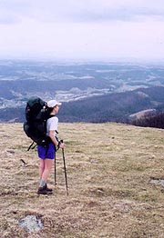
| Love hiking these alpine meadows for a change |
|
3/19 Dickinson Gap – War Spur Shelter (17.6 miles)
"Those who are enjoying something, or suffering something together, are companions.
Those who enjoy or suffer one another, are not."
C. S. Lewis (That Hideous Strength)
The night is marked by a stout wind and occasional rain, finding as we wake the rain ended, but the wind as strong as ever. As we descend from Pine Swamp Ridge we run into Jag, Anna, and Doug – Jag and Doug section-hikers like ourselves (1200 miles done), who've just run into Happy at the next shelter down (Pine Branch), suggesting the name "Grumpy" might suit him better (the effects of his sour mash being mightily in evidence). We break at the shelter before descending to Stony Creek, where the trail architects have played the first of numerous tricks on us. Across the branch lies a nice straight, level road through the green valley, though the AT is a roller-coaster of rough hills and rocks paralleling the road on our side. We’re not happy about it but we continue towards our planned late lunch at Bailey Gap Shelter. Pulling up to the shelter trail, we find a note on a tree suggesting the next spring is dry, although it’s dated 10/19. We decide not to take the chance, stopping to filter water here before we continue a couple tenths to the shelter for lunch. From here the trail climbs to the ridgeline, which turns rocky and punishing, slowing our pace (though the trail remains on the west face of a rock ridge, at least providing shelter from the wind).
|
| At Salt Sulfur Turnpike the trail crosses through to the ridge's east face, shrouded in a blanket of cloud and fully exposed to the raw east wind. A couple of VA Tech students are up here scouting out the area for a weekend outing, and we chat a bit about our hike and the shuttle system. It’s a cold and foggy trip down the ridge from here on, but finally a sign appears, showing a mere 1.3 miles to the shelter in the dreary dusk. The descent finally starts, and soon after our expected arrival time passes, spying a small shed in the valley below, though still a long ways beneath. It’s hard to see how we’ll get down there, and I become a bit more worried as the trail winds off in the opposite direction. We wind around the knob on the descent, wondering what’s wrong with our navigation until I finally get out the map to confirm our direction. It’s tough to tell much from the lack of detail here, so we push on as darkness falls, having decided that even if we’ve somehow overshot it, we’ll find a tent site in the valley. Finally we reach the shelter (still wonder about the extra 20 minutes –perhaps a relo?), typical of the shelters of the section, but nonetheless, a welcome relief in the misty dusk (and an equal relief that we’ve the shelter to ourselves, "Happy" obviously being well ahead). It’s cool enough that a fire seems in order, so I work on that as Coleen cooks dinner, with a nice relaxing evening together, finding from my Walkman that the Iraqi war has been joined, with an airstrike last night on a command bunker, and the ground assault tonight. We’re both tired, turning in under a light rain at an early 9:00.
|
|
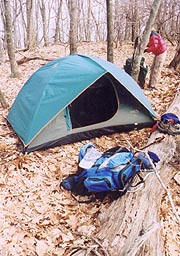
| Packing up at Dickinson Gap |
|
3/20 War Spur Shelter – Niday Shelter (18.2 miles)
"The real test of a man is not how well he plays the role he has invented for himself,
but how well he plays the role that destiny assigned to him."
Jan Patocka
The rain continues all night long, forecast to continue the entire day hence. We get around grudgingly at 6:30, stowing our clothing and such in plastic bags within our packs for additional protection. Finally, with all our rain gear on, we head out into the deluge, with a short descent to the valley, during which I’m somewhat comforted to find us comfortably warm in spite of the continual rain. Things change in a hurry though when we turn uphill to climb Johns Creek Mt, soon finding ourselves drenched in sweat. It's a grueling climb even with our sleeves rolled up and jackets unzipped, but once atop the frigid wind hits our wet clothing, and we’re shivering as fast as we’d been sweating. This turns out to be the pattern for the day – an endless cycle of hot and cold, of sweat and shivers, rarely ever in much comfort. At least we’re not dangerously cold atop, and after our first major descent we stop into the Laurel Creek Shelter for an extended break, breaking out the stove for some coffee. I decide here to switch to my heavy gloves (Coleen’s started out in her heavy gloves wrapped in plastic bags to keep them dry), though my fingers are so cold I can’t even pull them on by myself, needing her help to get them on.
The coffee helps though, and we resume our rainy trek into Sinking Creek Valley, the trail crossing a myriad of styles as we traverse cow pastures towards our next potential break – a church pavilion at VA 42. Though overnight camping is not allowed here, we’d hoped for a few minutes out of the rain, though when we arrive at the road the pavilion doesn’t appear nearby, the church itself being quite a ways down the road. We continue, with a hop over a small meadow to the nearby VA 630, running into a southbound trio of guys out for spring break. They’ve been a bit daunted by the numerous climbs (we’ll find out about this tomorrow), having reduced their trip to meet their pickup at 42, seeking a confirmation of their current location. From here we start the day’s 2nd tough climb – far smaller than the last and well-graded, but still tough in our stifling rain gear. Topping the ridge we proceed along surprisingly easy trail with all the rocks piled in neat stacks aside the trail for unknown reasons. We expect to pass the next landmark here – Sarver Cabin (remains of an old homestead), but soon we think we must have passed it unseen. We finally get to the sign, a bit surprised to find a shelter’s now been erected there (it’s a steep .3 miles off trail, so we don’t go down to see it), and further depressed to find a new sign here indicating a full 7.3 miles to the Niday Shelter, when all our other info indicates a mere 6 miles. This is truly disheartening, as it’ll mean arriving after dark in this miserable weather, but we push on as best we can.
|
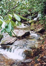
| The rhododendron groves are filled with surging streams |
|
| Even in the rain there's some color to be seen. |
|
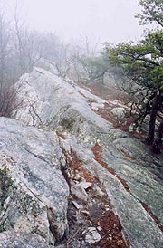
Adding insult to injury, the trail architects soon conspire against us, routing the trail for at least a mile along a steeply sloped slab of granite, pitched like a rooftop; even though a fairly flat stretch of forest lies just on the west face of this slab. It’s very rough going, especially in the rain, and three times I slip and fall on the rocks as my boots lose traction. Coleen slows to a crawl, and we’re both damning those architects so bent on our destruction as we pick our way through the difficult stretch clueless of our progress. No landmarks, no views, no signs, and the additional 1.3 miles to go must indicate a relo not shown on our maps. We’re badly disheartened, but finally the descent off the ridge begins, with darkness falling quickly as the sun sets, still expecting another hour to the shelter. Just as we’re about to don our headlamps, I see the shelter to our right – joy of joys, our info was correct, and the brand new sign wrong! We’re elated in spite of our battered feet and bodies, and it’s great to pull out of the rain into the dry shelter – this one with a nice fire pit (although all the wood’s wet), and even a nice stairs up to the shelter deck. We hang our wet clothes all around the shelter and set about making dinner – tonight’s treat being scrambled eggs with our ramen noodles, although for some reason they come out quite runny. We mix it all together though and it’s great, following up with the usual hot drinks and a quick report on the war, turning in quite comfortably at 9:30.
3/21 Niday Shelter – 4 Pines Hostel (15.9 miles)
"Doubt is not a pleasant condition, but certainty is absurd."
Voltaire
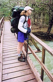
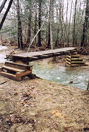
It's cloudy out, but the rain is over, and we festoon the outside of our packs with our wet gear in hopes of getting some drying this afternoon. We're out early this morning, with the skies starting to clear within an hour or so as we traverse Craig Creek Valley. Here we cross a maze of swollen creeks, winding back and forth across them, but luckily there’s a bridge for each crossing, including one that appears in mid construction, without even a railing yet, but enough to cross the surging tide – timing is everything. The route winds so much we suppose it to be a possible relo, but finally we start the long uphill indicated on the profile, climbing on switchbacks along a rocky, pine-covered spine. It’s a tough climb, but in shorts and T’s it’s far easier than yesterday's, and as it clears I stop ľ of the way up for a photo of the rapidly clearing clouds beneath. I send Coleen ahead, but as I try to take the pix, I find my polarizer fogged, then the lens; and by the time I find some dry cloth to clean each one, the cloud’s rolled back in and the view is gone. After waiting a few minutes for it to reappear, I finally resume my trudge to catch her, though I never get another chance at the shot.
At the ridgetop is a bench where I look for her, but it's empty, so I push on, the trail joining a very pleasant road upward. Soon after I see her ahead, catching up to her just before the Audie Murphy Monument. A shrine to a highly decorated WWII hero who died here in a plane crash, it proves a good place for our am break. By now the skies have cleared to glorious blue, with the temperatures warming to a nice spring day as we descend on easy path to Trout Creek, stopping to filter water and take lunch. It’s warming quickly, and it seems prudent to tank up here, though by now Coleen’s developed a nasty blister under her right big toe, so I carry the extra water.
|
|
| A challenging platform when dry, but downright treacherous in the rain |
|
| One last look at all yesterday's rain |
|
After lunch we resume the long climb to Dragon’s Tooth, which we know will be rigorous, but turns out positively grueling on our first warm day of the year. We pass the Pickle Branch shelter a tad early, but this is our last landmark, and the trail is routed directly over the top of numerous small knobs, each of which appears to be our destination. Each proves a false hope, and the trail becomes increasingly rocky, with the short downs between the knobs magnifying the punishment beyond belief. Both our feet are hurting badly, and there seems no end – we're finally positive we’re to the final knob when a couple southbound weekenders pass, advising we’re still about :25 out. Each time hope appears, it’s withdrawn after topping the knob; but finally we come to the sign, and after a short walk past we find ourselves near Dragon's Tooth itself, taking a seat for a well deserved break. After a few minutes here I decide to look further, finding the real formation, which is spectacular, although barely worth the punishing climb. We take a few pix and start the final descent to our destination, which begins with a few hand-and-foot climbs down rock faces, a couple supplemented with steel ladders. By now the pain in Coleen’s toe is pronounced, slowing her considerably on the rocky path, though my own aching foot and knee have mitigated somewhat (after an Advil atop). Still, it’s a long and grueling descent, with Coleen making it clear she’s considering aborting after tonight. We pass several groups of kids heading up for the sunset, and as our descent approaches level ground, we hear a couple kids on dirt bikes out tearing up the countryside.
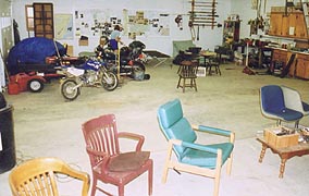
The traffic roar of Rt 311 soon dominates the valley, and before long we emerge from the woods at Rt 864, where our guidebooks indicate the 4 Pines Hostel is located a mere .4 mile to the east. I’ve tried to contact them on the cell phone a couple times today (it works at the high spots), but failed, so we’re unsure what we’ll find as we head that way, although we sure don’t feel like continuing on another 1.6 miles to Rt 785 (where there’s a B&B alternative). Heading up the road we see the dirt bike kids we’d heard from afar, with one of them (Joe) coming over to welcome us to the hostel, saying we’re the 2nd hikers they’ve had this season (it’s their 3rd season of operation). He points us towards the hostel, which is their garage / tool shed out behind the house – spacious but dusty, and containing a number of cots and mattress pads, along with a wood stove and a shower in the corner. It’s actually a bit better than expected, and we settle in as Joe makes a path with a broom. He calls his dad (also Joe), who often takes guests out to eat at the nearby Homeplace (a local AYCE buffet with a great reputation), so we shower and get presentable; though we’ll find that Joe Sr is predisposed, and won’t be back for by dinner time. With a stove and microwave though, it’s so easy to make dinner that it’s almost a pleasure, and we dine getting news from the war over a small tv (the picture isn’t working, but we’ve got audio). As we settle in to read and catch up, Joe and his girlfriend Angie come in, having bought some Chinese food on the way in case we’re hungry. They’d offered the use of their truck for us to head out and eat earlier, but somehow Joe Jr didn’t get the message. We're plenty satisfied anyway, so after chatting with them for a bit (great hosts), they take their leave, and we retire soon after at 10:15 (ahh, the joys of electricity).
|
| There's no railing yet, but it sure beats fording the stream!
|
 |
| Dragon's Tooth
|
|
3/22 4-Pines Hostel – Lambert Meadow Campground (16.4 miles)
"Those who would see wonderful things must often be ready to travel alone"
Henry Van Dyke
|
|
With our aches and pains, who’d have ever thought that today might turn out to be one of our favorite days on the trail? We’ve slept pretty well, awakening at 6:05 with Coleen's toe continuing to swell, though she seems up to continuing; leaving a healthy donation in the box before shoving off. A few minutes later we’re at the trailhead, with a typical hop over a hill as we traverse a number of meadows and stiles heading over to 785. We pass a small group of campers by a pastoral stream on the way, and at 785 is a beautiful house which might be the B&B where we could have stayed last night. We climb out of the meadow here at a surprisingly steep grade, joining the ridge in what will be come a series of PUDS (pointless ups and downs) as the trail architects continue to route us over the exact summit of every single knob on the ridge. It’s tiring, but at least the weather today is far better than before, and we climb up and down, up and down, wondering if we’ll ever get to Rt 311. Finally we stop for a break, during which a foursome comes by, having hiked up to a local knob, and confirming we were almost there.
|
| OK, it looks a bit strange, but it was comfortable and the hosts most gracious.
|
|
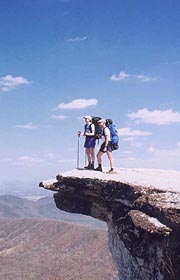
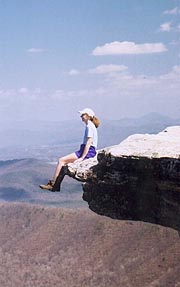
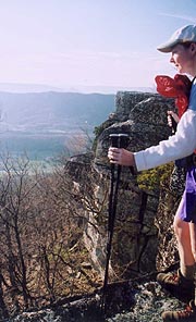
Sure enough, we cross 311 in minutes, having made far better time than expected; after which our day's big climb up McAfee Knob is to begin. It’s obvious we’re in now in a popular tourist section, as all the slanted rocks the trail crosses have wooden bridges built adjacent for sure footing (sure could have used those two days ago), and it’s actually a nice walk through terrain reminiscent of the Ozarks. We pass the dilapidated Boy Scout Shelter and later the much nicer Catawba Mt shelter, with a huge group of teens coming past us from the summit just before we reach it. Finally, we come across a confusing signpost chained to a tree (it’s been turned so it doesn’t point correctly), finding the side trail here leads to the knob, which is every bit as stunning in its beauty as we’d been led to expect. It’s vacant, so we hurriedly assemble our camera gear for a few pictures, starting with my taking pix of Coleen out on the knob. I’ve pondered earlier about taking one with feet dangled over the edge, but when she removes her pack and heads out to so pose, it’s incredibly scary from my vantage. I take a quick pix before asking her to back away carefully (she insists it’s not at all scary from her vantage), and she takes similar pix of me out there (sans the dangling legs picture). We manage a quick one of us both using the tripod (barely enough time for me to run back into the frame before the timer goes off), and just as we’ve taken this, a group of weekenders come up. After taking pix of all with their cameras, we settle back for a leisurely lunch in this spectacular setting.
Finally it's time to move on, marveling in the beauty we’ve beheld, with a gentle descent past Campbell Shelter, where we run into a couple guys who give a sterling report on the Lambert Meadow campsites. Again, it’s tough to guess our progress, but we pass what we think to be Brickey’s Gap at 4:10, starting the climb up Tinker Cliffs immediately after, with a break at a convenient log. We’ve heard of a small herd of feral goats known to accost hikers here, but we’re a little disappointed not to see them (Coleen suggests they might be down lower calving this time of year – or perhaps “kidding” is the proper term for goats?). It’s another arduous climb, but when we get to the cliffs the view is stunning – a full half-mile of cliffs shining in the setting sun, reminiscent of the Cliffs of Moher in Ireland. They’re glorious, and the path takes us perilously along their very edge, with me rapidly using up the few remaining frames of film on this roll. We’re a bit disappointed to leave the cliffs, the trail turning south along the eastern face of the ridge before finally turning down towards tonight’s destination – the Lambert Meadows shelter.
It’s an easy descent and we’re both still a little energized by the day’s wondrous sights, but as we approach the shelter we see a couple tents around it, the picnic table covered with gear, and a fire going. Pulling in we find a strange crew here, a couple of whom appear positively anti-social and a two more who’ll talk to us, though between the crowds and the dilapidated shelter (a serious lean to it), we decide to try out the guys’ recommendation of the campsite below. We see the stream bottom early, but not the campground until reaching its cutoff trail, finding a picnic table and a nice flat area immediately adjacent to a clear babbling brook. It looks wonderful, and I start with the tent setup as the sun sets, after which I start a fire as Coleen works on dinner. There‘s a bit of wind through the gorge here, blowing over the tent a couple times before it's weighted down, and soon we’re sitting next to the fire gazing at the myriad stars and reflecting on our great day. I catch up on the radio a bit as Coleen makes some calls on the cell phone (mainly for the novelty of it), and we turn in beaming at 9:30.
|
|
| Atop McAfee Knob Coleen scaring me to death |
|
|
3/23 Lambert Meadow – Daleville (9.1 miles)
"I want to stay as close to the edge as I can without going over.
Out on the edge you see all kinds of things you can't see from the center."
Kurt Vonnegut
|
|
We’re up early, with easy prep (our last day - doesn't have to be neat), getting out at 0715, and immediately realizing that we’ll be way early for our 1:30 pickup. As we head down the easy trail on this clear day, it becomes even more obvious we’ll get in around noon, so as the morning goes on I try a couple times to get Brenda and Buck on the cell phone without success. The trail’s easy enough (though still with the “every single knob” philosophy), and soon housing developments just to our left indicate the end is near. There’s little of note, taking a short break just before Hay Rock (an easy landmark to identify, covered with graffiti - surely we’re near town now), and from here the final descent begins soon after. The morning warms quickly in the sun, but it’s mostly downhill from here, and soon we cross Tinker Creek, winding through some fields and pulling up to US 220 right at noon.
With time to kill, we have a leisurely lunch at Pizza Hut before heading over to the Econo Lodge a few minutes early. Over here we find Charlie, the one fellow who spoke to us at the shelter last night, loading up his gear as he awaits a callback from Del for another shuttle and another day of hiking. We find he’s a section hiker like ourselves, wanting to do the hike down from Black Horse Gap, and is hoping for a shuttle from Del to do same. We chat for a bit before a call on my cell phone finds Brenda - on her way to pick us up, but lost in the process. After finding the correct exit, she’s on the way, only a few minutes away. As she shows up and we load (her friend Becky along to help navigate), Charlie comes back over, having not had any luck with a couple of shuttlers whose numbers I gave him; and though Brenda tries back Del on a couple of numbers, eventually we have to head for Pearisburg as he awaits the callback.
|
| Beginning our long and stunning walk down Tinker Cliffs last night
|
It’s an entertaining trip indeed with Brenda on the way south, as she talks the entire way of her two semi-delinquent sons whom she’s sending into the military, the strange hikers that have come through, her time in the pen and such, all very entertaining and the perfect end to our hillbilly traverse. It’s a long drive down, but she’s quite accommodating once there, offering showers and such, although we're more anxious to check email and head for home (knowing I could be called back out any time). Coleen's knees have done well, and our few aches and pains will pass quickly, leaving us one step closer to Katahdin with some great memories and stunning pictures.
| |


