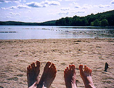
The Epiphany
¤
Where time is counted an ally, and not an
adversary
Stormville NY - Bellvale
NY It's time to face the demon - our first August
hike. We recall all too well last summer, when temperatures
topped the century mark for weeks on end, with humidity to match;
and the springs ran dry. This is a different animal however -
the coolest and wettest summer in recent memory, as we found all too
well in our past two sections. Still, the June section kicked our
butts, and that at high altitude, mitigating the heat
considerably. It's time to head north, though our schedule precludes
going too far - NY looks appealing. The sights are legendary -
Graymoor Friary, Bear Mt. Bridge, the Lemon Squeezer; and after
northern TN it'll be a welcome change to be able to hitch for town
food occasionally. So, the die is cast, the Rubicon crossed - it's
off for the Empire State.
8/18 Stormville NY - Canopus Lake tentsite (10.9
miles)
"While all the night, through fog-smoke
white,
Glimmered the white Moon-shine.
Samuel Taylor
Coleridge, The Rime of the Ancient Mariner
We begin at the home of
Ralph (our shuttle), a two-time AT hiker whose house is poised a mere
400 steps from the AT. It's all
as advertised, and by 2:22 we're on the AT, finding a
number of stone cairns built there and our first deer almost
immediately. It's a beautiful piece of trail, replete with hemlock
groves, babbling brooks, and the occasional stone fence, and mirroring
the day's beauty with numerous overlooks. A new
underpass gets us across the busy Taconic Parkway, and on the other
side is a beautiful flowing stream, with a large and tempting pool
suitable for bathing.
Minutes later we come on the RPH
shelter, carved out of a thicket of vines on the edge of a small
town. RPH (Ralph's Peak Hikers - a hiking group Ralph organized) is
a wonderful shelter, with bunks, windows, a picnic area, and a desk,
and supplied with some trail magic from Big John (a cooler of soft
drinks with a note that he'll be back at 1830 for pizza orders). The
$1 DC hits the spot, and we linger for a long break as we peruse the
register. We'd love to spend the night, but if we're to reach
Graymoor Friary tomorrow, we can't tarry. |
|
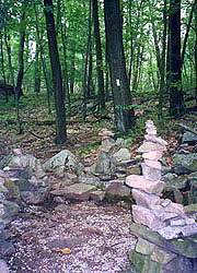
| Trail cairns near Stormville NY
|
Soon
we break out on a beautiful overlook of Canopus Lake, the beach and
campgrounds (with showers and water) tantalizingly close below,
though access is via the dam at the far end of the lake, with a
mile's backtrack (it'd be pitch black long before we could complete
this). Only later will we find that a small wash we passed would
have made a quick 1/4 mile bushwack down.
Instead, we wind through the hills west of the lake -
darkness is falling quickly, but our goal of dinner at the Friary
tomorrow means 'miles to go before we sleep'. In our typical pattern
we start looking at 7:40, lowering our standards
each few minutes as it becomes darker.
At 8:00 we
find a cozy site with a lake view - fronted by hemlocks, and
with a large stone ridge on the lake side; though shoehorning
the tent into the space proves challenging.
Coleen sets up kitchen on the ledge, and the
rising moon is veiled by the thin clouds, reflecting off the lake
far below. We've plenty of water until I tip the pot over during
the evening drink service,
spilling over 2 cups of this precious commodity. We'll still have enough,
but we have to find water early tomorrow. The next trial is the bear
bag, the only suitable branch being very high, with conflicting
branches all around. |
|
Finally we turn in at 10:45,
though sleep comes hard, with jets flying over in the early evening,
and later a wild screeching sound like a wounded fox. The moon comes
out later with a warm glow, signifying the breakup of the clouds as
we drift off to sleep.
8/19 Canopus Lake to Graymoor Friary (12.6
miles)
"Do not neglect to show hospitality to
strangers: for by this some have entertained angels
unawares."
Hebr 13:2 Waking on this foggy morn, we
find the shore a lot closer than it looked last night in the
dark, and ourselves well rested in spite of our precarious
perch. Coleen's trying bagels as breakfast fare, and we have minimal
coffee in light of last night's aqueous debacle. We're walking at
7:22, our first priority being water - the lake is laden with algae,
so we wait for a clear running stream. Though tinted,
it was found near the ridgeline in a rocky bed - good enough for beggars
such as we. Passing the south end
of the lake the fog lifts, revealing a beautiful morning with clear
blue skies. |
|
After crossing the dam, the trail
follows the remains of a small mining railway, built up to a huge
stone causeway on whose crest we hike. The trail is dominated by
short but steep climbs and descents, and as the day warms, it wears
on us early. Coleen and I have differing opinions about our break point,
and she responds by slowing to a crawl, even as the terrain moderates, compassing a swamp and some
cornfields. Finally we reach Dennytown
Rd, finding a stone building with a
water tap supplying excellent water. Coleen pulls up a few minutes later with
aching knees, and promptly hurls downs her pack to collapse on it as
long as I'll allow. We spend about 20 minutes before continuing,
with only a short walk past South Highland Rd before
lunch.
Chapman Rd brings a needed dose of trail magic - jugs
of ice water left here (the anonymous trail angel lives a few houses
down), and though we've plenty, it's far too good to pass up. The
trail passes several beautiful overlooks, and as we walk a tall thin
hiker comes blazing by us. We manage a few words before he leaves us
in the dust, finding him bound for the Friary also well. We make
good time to its entrance, where a blue-blazed trail
points us to the ball field shelter, our lodging for the night
(traditionally hikers stay in the Friars' cells, though the Friary
is now housing a group of Carmelite nuns whose convent has been
destroyed by fire).
The AT has traversed the Friary's
property for untold years, although the current hospitality began in
1972 as an unnamed hiker wandered in seeking food and shelter. The
Friars took this as a logical extension of their mission,
and it soon became permanent, a table set for hikers nightly.
Currently battle lines are drawn between Graymoor and the National
Park Service over NPS plans to take over the trail corridor - still,
the Friars' hospitality to hikers continues unabated.
The
road passes a graveyard with the requisite shrine, where the beauty
and tranquillity of this place begins to soak in. We direct a
passing car towards the shelter, on arrival finding its occupants
the parents of Fungal, slackpacking she and fellow hiker Pepper Head
in from Bear Mt. They've been slowed in their thru-hike by athlete's
foot (hence the name Fungal) and injuries from a recent tuna-can
stove fire. The parents have tons of food (they offer some, and
we're only kind enough to accept), and they end up leaving this all
for the kids before heading on. We also find "Nightmare" (the hiker
who passed us) waiting for the Friar to summon us to
dinner.
We discover he
started his southbound hike last month, on track for a Thanksgiving
finish. On submitting his resignation from the state of PA, he was
given a leave instead, and has been receiving great support from his
co-workers. His big story is of the death of Crash '90,
whom he passed "resting" on an overlook near Kent CT a few days ago,
found soon after to be dead. Crash seems victim to a heart attack,
based on the medication found in his pack, although the Kent police
still held Nightmare up for questioning. Soon Father Fred comes down to
introduce himself, having worked with the hikers almost since the
program's inception, and knowing most of the trail icons by name. He
leaves us with a map and 45 minutes to spare, time enough for a
quick cold-water shower (more birdbath than shower, but
still refreshing). It's also a good time to reconsider
our original schedule - Plan A was to have dinner here, then hike on
another hour to Hemlock Springs, putting us in range to enable a
Monday finish. My male, goal-oriented, ego-driven side
likes this plan a lot, but I have serious doubts about it; and
besides, I'd have to motivate Coleen, something I've not excelled at
lately.
"So hon, how do you feel about going on to Hemlock
Springs tonight?"
"You're asking me?"
"Of course, we're
a team."
"Well then, the team is staying here for
the night."
"Well geez hon, I guess if you insist."
Now
see, this is the sort of thing 15 years of marriage teach you -
I'm every bit as tired as Coleen, unsure if we'd even make
Hemlock Springs by nightfall, with serious doubts about two
back-to-back 16-milers following. Not only have I got my way, but
Coleen supposes it's all a concession to her. This is great - an ample
meal, a shower, and a marital coup to boot. Before the section is
over, we'll count this moment as a turning point of our entire pilgrimage.
|
| Decision made, we head to
the dining hall, joining Father Fred along with a retreat group,
some friars, and the Carmelite nuns. After an
inaudible public blessing the soup and garlic bread arrive, followed
by spaghetti and huge meatballs with pitchers of Kool-Aid consumed
in abundance. Father Fred sees to it that the bread and spaghetti
are multiplied, and we chat about their ministries, including one
for wayward men, a substance abuse program; and about
various hikers, including poet "Nimblewill Nomad" and "Family" -
a mother with 5 kids bound for Katahdin. It's a great time, and
we're left with several bags of garlic bread for later, taking a leisurely
stroll around the grounds
before returning.
|
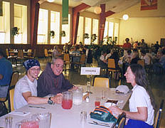
|
| Feeding the multitudes with Father
Fred, Coleen, and Nightmare |
Fungal and Pepper Head soon walk in,
and go to work heating the Chinese takeout
left for them. Another car pulls up, with a couple emerging,
the girl calling herself "Oreo", her hike having been interrupted,
and now seeking to play trail angel. She really wants to chat about
the trail and such, but between the mosquitoes now swarming about
and her incessant chatter, it's hard to say which is the more
pestilential. Eventually I wrest myself away, and another hiker (her
partner, perhaps) answers a few questions I have on the upcoming
trail, with amazing factual clarity. The mosquitoes soon have me
wearing every piece of clothing possible, and as night falls we
retreat to the tent, turning in with a satisfied glow at 9:30.
8/20 Graymoor to West Mtn Shelter (12.2
miles)
"Thousands of tired, nerve-shaken,
over-civilized people are beginning to find out that going to the
mountains is going home; that wildness is a necessity; and that
mountain parks and reservations are useful not only as fountains of
timber and irrigating rivers, but as fountains of life."
John
Muir It's cold overnight, and we're up early, though
with our new relaxed schedule, there's no urgency to break camp.
Afoot at 8:15, we pass through the Graymoor property in a deep green
forest with several deer foraging about. After passing a Mini-mart
on Rt 9 and a couple of stiles (easier to bypass than climb), we're
soon on a carriage road which is such easy walking that I'm having
serious regrets about not having continued this section last night.
We're racing along savoring the beauty when I suddenly realize it's
far too easy, and we haven't seen a blaze for some time now. A quick
stop and look at the guidebook confirms my fear - we've been off the
trail for some time, and now must backtrack.
|
We make good time back to
the AT intersection (the double blaze invisible in dappled
sunlight, right at a stream crossing requiring fancy footwork)
having lost almost 1/2 hour. The trail turns up a fire road
to Hemlock Springs campground,
our intended site had we continued last night. As we break here,
we find one campsite above too sloped for camping and full of trash.
The lower campsite holds a tent of teenage
boys recovering from the influence of Bacchus, their trashed site
standing in stark opposition to the beauty and simplicity of our
night at Graymoor. All told, it was a good choice to slow the
pace, a fact soon to be confirmed.
It's a
delightful path towards the Hudson in excellent weather, and with
time to spare, we take the .6 mile side trail up to Anthony's Nose
for a look (competing theories exist for its name, but its nasal
aspect is clear from a topo map). We slack it, stowing our packs
behind a large rock, energized by our bare backs; a noon whistle below
blowing exactly as we emerge onto this beautiful outcropping.
Several Sunday tourists are here, one a fireman from
Nyack with whom we chat for a bit. It's absolutely gorgeous up here,
and the Bear Mt Bridge appears almost straight down below us,
making for excellent pix (though I forgot the "Our Toes on
Anthony's Nose" photo, which would have been perfect). We look down
on a Beech Bonanza flying up the river, and the Hudson is full of
pleasure craft seizing the day. We could stay for hours, but hunger
impels us towards town. |
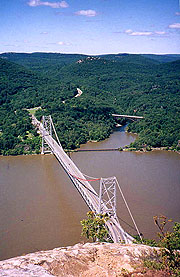
|
| The AT's lowest point - crossing the
Hudson |
|
As the steep path
approaches the bottom, the roar of a pack of Harleys overwhelms, as
though all New England has come to share this perfect day. The
bridge itself is equally stunning from ground level, the white
blazes leading to a small foot path along its north side. As we
cross, it's a giddying sensation to look out through the rails at
the treetops far below, guaranteed to make anyone a little wobbly in
the knees. The Hudson's full of boat traffic below,
but the real thrill is looking down on the RR tracks
as a train roars by underneath. From our height, the
cars look like toys, and it's hard to believe from this that on
reaching the end of bridge, our 176' elevation will be the low point
of the entire AT. The tollbooth at the west end looks like a
miniature chalet, and there we begin a search for entry to the zoo -
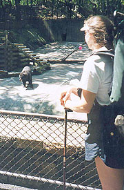
the only such zoo through which the AT passes.
The blazes
point to a service entrance - with packs on, no one pays us any heed
entering this way (no charge for thru-hikers), though once
inside, we're as much an attraction as the animals, with several cameras
discreetly pointed in our direction. With no sign of a
restaurant, we forge ahead, passing our primary
goal - the black bear exhibit. We can now say we've seen our 1st
bears "on the AT" (a little deceptive, sure, but it is the
Clinton era), and we learn quite a bit on the various flora
and fauna as we pass. At the main entrance are vending
machines and a huge swimming pool, but we've no time for the latter;
and wanting better food than the former, we drive on. A tunnel
takes us beneath US 9W, emerging into a beautiful and crowded park
surrounding Hessian Lake - we'd seen this from the Nose, but with no
idea we'd pass through. Of all the wondrous sights today, this is
perhaps the most incredible - we walk amidst mammoth crowds of all
ethnicities enjoying this final Sunday afternoon of the summer - and
still on the AT! The smell of a thousand barbecues stokes our
hunger, leading us to the beautiful Bear Mt. Inn, with a cafeteria
within.
We meet a couple thru-hikers here - Animal and
Optimist; and though Animal books early in our meal, Optimist chats
with us as he consumes an entire 16" pizza. They were both cadets at
the USNA who decided to punch out and hike the AT (he's educated
enough to make this possible), finalizing their decision on 5/25,
and leaving Springer with no prior hiking experience on 6/5. He says
they've regularly been doing 25+ mile days (possible in this area),
and that they're bound for Graymoor tonight, though they'll miss
dinner. It's been fun , but soon we must cap off dinner with ice
cream, and head on our way. |
| Our first bears on the AT
|
|
| Roughing it at Bear Mt. Lodge
|
| The climb up Bear Mt
has hundreds of side trails full of
weekenders seeking directions, slowing our progress. It takes
exactly an hour to the Visitor's Center, a melting pot if we've ever
seen one. There are Japanese, Chinese, Indians, Hassidic Jews, and
too many others to count, many in native garb. Clawing our way to
the top of the observation tower, we find excellent views in all
directions, including the next ridge, where we'll shelter tonight.
Some Jewish boys are abuzz with questions about us and our hike, and
we're all to glad to answer, but eventually we have to be on our
way. As we top our water we meet Stealth
and Croatalus (the latter clueless who his trail
namesake is, making me think we're vacillating far too long over our
own trail names). We start down the road walk, with heavy
traffic coming down the mountain as closing time passes. Finally the
trail turns off into the woods
before ascending West Mountain, today's final climb.
After a steep but short climb to the ridgeline, we're back in the
welcome sub-alpine environment as the sun slowly sets in the west.
The blazes are few and invisible amidst scrub oak and tall grass,
but we manage to follow the trail, soon reaching the blue-blazed
trail to the shelter. It's a long 20 min (.6 mile) there, and with
the trail far less level than advertised, it's tempting to stop at
one of the many campsites on the way, all with great views. We press
on to the shelter however, and soon we see campfire smoke, with the
old stone shelter appearing suddenly. The view is all we've heard
and more, the Hudson Valley laid out before us, and
the NYC skyline dead ahead, the Twin Towers clearly visible
downtown as are the Empire State and surrounding buildings in
midtown.
The shelter's occupied by Joseph, his son Mario,
and friend Taylor, and they have a smoky remnant of a fire going in
one of the two fireplaces at either end of the shelter. It's fairly
well trashed out, and the smoke within makes it bearable only for
short periods, but they gladly clear a place for us as we go to work
on supper (they're already done), although when Mario tells us a
mouse came out of the fireplace earlier, we plan to set up our tent
outside for sleeping.
They're a good bunch, and
well-equipped, though novices at camping, and as we cook,
a deer forages behind the shelter,
oblivious to our presence. Taylor falls all over himself
trying to help us, and we move the fire to a fire pit outside.
Soon we're roasting marshmallows along
with our caramel corn and hot chocolate as darkness falls, revealing
the lighted NY skyline ahead - almost as magnificent as the daytime
view. They all follow our lead and set their tent up outside too, and
we chat about the fundamentals of trail life as we sit around
the fire. Bedtime approaches, although
it's tough getting the boys to quiet down. As we retire to the tent,
we can't help thinking that this has been our best day on the trail
yet. |
|
8/21 West Mt. to Green Pond Mt. tentsite (11.6
miles)
"What's in a name? That which we call a rose
- by any other name would smell as sweet."
William Shakespeare -
Romeo and Juliet In the wee hours of the morning, we hear
the stomping and snorting of deer outside; but we ignore them, and
soon are back asleep. In fact, I'm out cold when Coleen finally
wakes me, seeing the sun high in the sky. It's 8:24 already -
how could I possibly have slept so late? We hurry through
the morning routine, finding we've slept through Joe and the boys' departure
as well - simply incredible. A goodbye would have been nice, but so
was my sleep, and at 10:00 we're finally on the trail, a beautiful ridge walk
in the sub-alpine terrain. |
|
| Hard to tell from this small picture,
but the NYC skyline is gorgeous here, day and night
|
Crossing the busy Palisades parkway we
find in the forested median a chair with a box of trail magic from
an anonymous trail angel, and a register. It's a good chance for a
break and a coke, and as we read the register we find word of
Crash's death has spread like wildfire through the trail community.
It's a revelation to us as well, impressing greatly on us how
tightly-knit is this band of brothers. We've procrasted
far too long in assuming trail names, though we've talked of several
options. Now it's clear that if we're to join the pilgrimage, it's
time to discard our workday identities, taking on the mantle of the
trail. From this moment forth, we are no longer Bob & Coleen,
but Wildfire and Wounded Knee - Wildfire from my pyrotechnics at Rod
Hollow shelter our first night, and Wounded Knee from Coleen's knee
strap that sustains her on the downhills.
Armed with new
alter egos, we still must keep moving, the parkway crossing likened
by one register entry to a game of Frogger, with us as the frogs.
The trail ascends Black Mountain, another sub-alpine ridge walk,
where we find a glut of blueberries growing along the path, too
appetizing to resist. We munch as we amble
along, although at this pace, we'll be lucky to finish the AT this
decade. We're also treated to a flight of two
Cobra helicopters flying by at eye level, compelling enough that we
stop and watch them pass (with a few more berries). Suddenly
around a bend appears our planned lunch break - the beautiful blue
Lake Tiorati, so close we can reach out and touch it. Unfortunately,
it's actually Silver Mine Lake, the first of several disappointments
for the morning. Ahead, the Ramapo-Dunderberg trail diverges from the
AT on a straight course to Lake Tiorati, while the AT winds
aimlessly through the woods to the north. No doubt many hikers take
the shortcut, but with our purity intact, we're committed to the
whole distance. Still, we're inspired by the sight of the lake, and
push on, wondering when we'll see a bear enjoying the blueberries as
we have (never did, though we step over garter snakes in abundance).
|
After crossing Letterrock
Mt, we suddenly find ourselves in a steep descent through a
difficult boulder field, and with equal suddenness, reach the
William Brian shelter at the bottom. Another stone shelter, it's
complete with bunks, and someone has put an expensive folding chair
within, as well as a lantern and batteries, an axe, and other
implements. The trail register is full of comments from hikers we've
come to know over this section, and we're really beginning to enjoy
this mode of communication. It's a good break, but we're
motivated for lunch at the lake, so after a quick review of the
route, we decide we'll be at the road to same in an hour, and push
on.
Soon the R-D trail diverges, where we utter a few choice
curses about those who would cheat on such things. As the 1 hr point
approaches, we cross the road a few minutes early, but as the trail
turns northbound, it's obvious I'm in error - this is not the road
to the promised land. The road we seek (the 2nd crossing of Arden
Rd) is actually another 2.2 miles in the future, and adding insult
to injury, the trail turns steeply up a totally unnecessary series
of hills. We're well past any chances to cheat, so it's onward,
cursing all the way. It's a featureless trail, save the arrival of
two fawns, sufficiently unafraid to allow a pix of them both (a
consolation for our efforts, Coleen points out). To heighten our
disgust, the muddy areas lack any bootprints of the many thru-hikers
we've passed, who obviously took the shortcut. Finally we meet the
correct Arden Valley road, where it's a short .3 mile walk to the
lake, finding a fair number of tourists as we steer a beeline
for the vending area by the beach. |
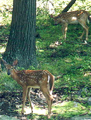
|
| Bambi & friend
|
|
We feast on sandwiches, chips,
and ice cream on a stone picnic table - we're in heaven!
As we do, a section hiker
drives up (Gene - he's done most of the trail south, though you'd
never know from his figure) - a local trail angel, and
quite knowledgeable. Coleen talks him out of a ride back to the
trail, even agreeing to wait while we grab a shower.
First though, thinking it'd be a neat thing to take a
swim, I strip to the necessary attire, heading down to the beach
where I find nobody's swimming. One foot in tells me why - it's
frigid, and might have been bearable immediately on arrival, but
certainly not now. After a quick shower (almost immediately running
out of hot water) we head to the trail, thankful to avoid this
uphill walk. |
| On the beach at Lake Tiorati
|
| We thank him profusely before taking to
the woods, with many miles yet to go before tonight's goal - camping
atop Arden Mt. (which would require us to finish the day with a
climb up "Agony Grind"). We climb Fingerboard
Mt quickly in our clean and invigorated state,
with the usual ups and downs. The deer are out in masse and
surprisingly tame, although the mosquitoes are emerging as well. After
a quick DEET stop, we head for
the next anticipated challenge - the Lemon
Squeezer. |
This narrow gap between
two sheer ledges requires we remove packs to hand them down - easy
enough for a duo, but far tougher for a solo hiker armed only
with rope. At the top we must swing around one rock
outcropping hanging on to a tree as we jump to the next one -
probably doable with packs on, but easier without, so off they come,
and I head down first, to take the handoffs. Both my hiking
pole and radio fall off their hangers in the process, although they
don't go too far down the slope and are easily retrieved. Coleen
adds to the buffoonery passing my pack down inverted, sending my water bottle
plummeting down the slope, a substantial climb below. We look like the Keystone
Cops, but we've miles to go and more squeezing to do, so
it's back to work. The lower portion of the Squeezer is a
long narrow channel through which the packs could be lofted overhead
and carried, though it looks easier to hand them over the other
side. By the time we're done the mosquitoes have found
us an easy target, so we're happy to get through and resume the
walk.
Back on the road, our first priority is water - the only source is
Island Pond before we climb Agony Grind. The pond looks idyllic
before the golden sunset, but hordes of mosquitoes persuade us
this is no place to stop. We filter water at its outlet, finding
it a bit tinted, so we save some clear water for
drinking, get going as quickly as possible. The trail climbs
Green Pond Mt - easy enough, though we're not looking
forward to the descent followed by the climb up Agony Grind in the
failing light. The road noise from NY State Thruway increases
rapidly as we approach the crest, at which point we're faced
with a decision. It's 7:30, 45 minutes until serious dark, and we'll
either have to climb down to the Thruway, cross, climb Agony Grind,
and continue far enough to escape the noise; or backtrack a little
and camp here.
The camping spaces here look great, with large
open spaces of long grass between the rocks,
and with ample time to make our
pickup tomorrow, we elect to call it a night. It only takes a few
minutes to find a good and quiet spot, and with daylight left, we
have the luxury of a relaxed camp setup.
Firewood's plentiful, and we build a fire ring
next to a large sitting log. Soon dinner's
cooking, the tent's up, a nice fire going, and the bear bag and
our packs both hung. It's a relaxing evening, and we turn in at
10:45 with both side vents open. |
|
| The "Lemon Squeezer"
|
|
|
|
8/22 Green Pond Mt. to Bellvale NY (13.3
miles)
"A rock pile ceases to be a rock pile the
moment a single man contemplates it, bearing within him the image of
a cathedral."
Antoine de Saint-Exupery We're up early,
with a leisurely morning before starting another beautiful day at 8:05 - a steep
but short climb down to Arden Road, which leads us across an overpass
over the Thruway. Traffic below is heavy, and we stop to smile and
wave in the middle
before heading up Agony Grind. It's far easier than the name implies,
with only a couple places requiring the use of hands, and all with
good hand/footholds. Soon we're atop Arden Mt, where the trail
continues through scrub oak on a fairly level pitch, though
rough enough that we'd have had a tough time finding a
good campsite last night.
Water becomes a concern, and though the path
skirts Little Dam Lake (with a beautiful sheer granite ridge on the opposing
bank, a tall hemlock grove above), the lake looks stagnant,
and the mosquitoes drive us quickly down the trail. We'll
pass Mombasha Rd around noon, and a town meal sounds enticing -
especially thinking of an icy Diet Coke there. With
no sign of a hitch, we hike in - .6 mile to the deli,
though we're in the outskirts of town in a few minutes. It's a
quaint little upstate town on the shore of a reservoir, with
beautifully flowered yards to pass.
Bentley's North is our delight, busy with the noon crowd, but very
hiker-friendly. We eat like kings on huge deli sandwiches, Cool
Ranch Doritos and a 2 liter bottle of DC (Coleen thinks we should
capture this spectacle on film), the owners bringing a hiker's
register with many familiar names.
As the crowd thins we chat with the proprietors,
discussing Crash's death (he'd left a register message here) among
other things. Thus sated, we walk back to the
trail, resuming our hike at 1:40.
More ups and downs take us
to our next landmark,
Fitzgerald Falls. The trail follows the stream down for some time,
and the final climb to the bottom of the falls is steep indeed, with
hands and feet pressed into service. It's a beautiful falls, though
too close to the road, as there are several fire rings surrounded by
trash in the area. As we pause for a couple of pix with the
tripod, a small troop of inner-city looking
boys passes by northbound, one of whom is a
little too interested at my camera on the tripod and my radio on the
ground, so we wrap it up and push on. |
|
This could be another Eden
were not the numerous campsites sadly strewn with trash,
no attempt having been made to even burn it in the fire pits. The
trail begins uphill, as the mosquitoes start to get the
better of us, we break at the hill's top,
slathering ourselves in DEET, and trying some Kool-Aid to add taste
to our warm water (we're spoiled from all this town food). The
Kool-Aid's a bad idea, making us even thirstier, but wisely we've left
Coleen's bottle untainted.
Two landmarks lie ahead - Cat
Rocks and Eastern Pinnacles, both rock escarpments with blue-blazed
trails bypassing them for the faint of heart or marginal weather.
Cat Rocks doesn't disappoint, the
guidebook calling it an "upturned strata of reddish conglomerate",
and though it requires a little hands and feet climbing, it's easy
enough, topped with a beautiful overhang.
I decide to try a shot of us both from the tripod, though
it's a long run from the tripod to our perch, and practice shows I
can just get it done in the timer's 10 seconds. Just before I hit the timer
however, a couple of Boy Scouts come up the path, so we enlist them
for their daily good turn. |
| Atop Cat Rocks
|
Next is the Pinnacles, just visible from
here jutting out of the woods. It's a short climb up to another
great overlook, and a little easier than Cat's Rock to traverse.
From here it's an easy path, familiar from when
we launched here southbound for our NJ segment, though the
mosquitoes swarm us with renewed vigor, finding a surprising number
of chinks in our DEET armor. We hurry down the path, soon hearing
the road noise and arriving at the intersection exactly as planned
at 6:15.
Moments later Ralph pulls up as promised, and I find him the
polar opposite to what I'd expected (partly because I'd
confused the words medication and meditation)
during our phone call.
He's a fitness addict and an
adventure junkie, espousing a New Age philosophy in spite of his
high-tech, button-down employment. A child of the 60's (having
probably experimented with the pharmaceuticals common to the genre),
his devotion to the trail is complete, as is his hospitality. I
could write volumes on this intriguing icon of the trail, but
suffice it to say he was able to entertain us continuously
throughout the drive home, as well as over dinner with his wife
afterwards – a fitting end to this, our most fascinating section to
date. |
| |


