Fright on Bald Mountain
¤
Where success is not measured by
overcoming the tempest, but enduring it.
Hot Springs NC to Erwin TN
We haven't done a long
section since October, and the prospect of February weather
gives us plenty reason to fear. But, if we're ever to see
Katahdin, now is the time to "take the bull by the tail and face the
situation".
2/18 Home to Hot Springs NC to Rich Mt. campsite
(8.4 miles)
"You'll be bothered from time to time
by storms, fog, snow. When you are, think of those who went through
it before you, and say to yourself, "What they could do, I can
do."
Antoine de Saint Exupéry - Wind, Sand and
Stars
Our drive down takes us to Elmer's in Hot Springs,
where we've arranged to leave our car for its shuttle north. After a
quick chat with Elmer (finding to our delight that Caveman and Spike passed through
a week ago), we
hit the trail at 3:30, walking through the quaint downtown area.
After crossing the French Broad river the trail turns up the
riverbank - the river's beautiful on the clear day, and mighty in
its surging fury.
The trail climbs towards Lover's Leap
(Cherokee legend holds their maiden, Mist on the Mountain, threw
herself off after her lover Magwa was killed in battle). There are
many beautiful overlooks, and as we stand on one,
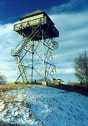
some weekenders emerge, having just spent a night at the campsite by the
Rich Mt. Fire tower, which they highly recommend. It's forecast to be a cold night tonight (17F
down in Asheville, and it's already 32F out here, crunching the
familiar "ice pipes" underfoot as we walk.
A pond ahead holds what's
termed "an excellent campsite", the only time I've ever seen these
words in an AT guidebook. I expect a little slice of Eden, nestled
in the pines, perhaps a valley overlook in one direction and the
tranquil mountain lake in the other; but on reaching it, nothing
could be further from the truth. The pond is stagnant, the campsite
a small, marginally level space in the mud at its far end, and the
area behind graded for future construction. A small pile of
industrial lumber lies here for firewood, but other than this, I see
no merits whatsoever. Coleen agrees, and we push on to Rich Mt,
knowing we'll arrive well after dark. We're armed however, with our
new Petzl headlamp, and with temps dropping, walking's warmer than
sitting around camp, so we hike on. The sun sets behind us in
brilliant red and orange hues, casting the Smokies in a beautiful
blue silhouette, but the night cools quickly, so soon both jackets
and lights are out. As night falls, a brilliant star emerges
slightly to our left - it must be Venus, but I've never seen it
shine so brightly - it looks like the star of Bethlehem that first
Christmas.
We soon pass the Rich Mt. fire tower trail, with a
spring and a "campsite - 50 yds" sign pointing into the woods
immediately after. It takes a long search through the brambles before we
finally locate the site, a good one indeed - there's a bench and a
table built, and plenty of level space for our tent. Building a fire
proves tough with wet wood, but soon we have soup
started, and dine on ham and cheese sandwiches on bagels (new tradition -
heavy food for our first meal). It's 9:00 before we eat, and in view
of the hour we abandon a plan to visit the fire tower for a look at
the stars (a good view right here from the campsite), getting to bed at 11:30. |
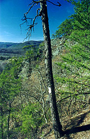
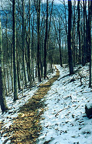
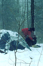
|
| The AT approaching Lover's Leap
|
|
2/19 Rich Mt. - Jerry Cabin shelter (17.9
miles)
"I may not have always gone where I intended
to go, but I think I have ended up where I intended to be."
Douglas Adams - A Hitchiker's Guide to the Galaxy We
wake feeling surprisingly warm, though it's still frosty out, the
water bag we'd forgotten to empty now frozen around the edges. It's
a great morning (always fun to discover what the site really looks
like in the light), and with coffee made, we elect to take our breakfast atop
the fire tower. It's a short walk, so we head over with camera and
coffee, finding the view spectacular, though there's a howling wind
from the south up here (odd, it's steady westerly in our campsite).
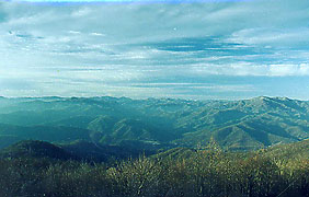
|
| A view with our coffee
|
We're out by 8:54, the
snow filling the northern exposures of the slopes, eventually
covering most of the ground save the trail itself. After passing a
memorial to Rex Pulford (died here of a heart attack during his 1983
thru-hike), we break at Spring Mt shelter, finding Spike's register
entry here with a few others of interest. At Allen Gap we'd hoped
for a last "town food" fix at the State Line Service Station, but on
arrival we find the station's been closed for some time. The lawn
out front's a good place to sit in the sun for lunch though, with a
couple of weekenders emerging from the woods (bound for Hot Springs)
as we do - after chatting and taking their pix at the state line
sign, we all pack up and head on.
It's a featureless trail,
and as 3:00 arrives, I pick a handy log for our break. Coleen looks
puzzled and asks why we didn't wait for the Little Laurel shelter,
which I advise is quite a ways further yet. Of course, when we
resume our hike, it appears right around the next bend, and we end
up spending another :20 there chatting with Uncle Shoe, Chili Mac,
and Doc Savage. They're northbounder's, and we've expected them
since leaving Elmer's (along with Comer and Jean, now a day ahead).
The trio here are slowed by Uncle Shoe (much younger and a little
heftier than the name implies), who's suffering from knee &
tibial pains. After a long chat and their update on Spike and
Caveman (now traveling with last year's final cluster of southbounder's,
including Tiny Tim and Heald), we finally push on for the last half
of our climb up Camp Creek Bald, with 1100' of elevation yet to
climb.
We'd thought of staying here tonight, but with our
extra miles yesterday we can easily push over the Bald, and find a
tent site after (making a Thur arrival in Erwin well within reach,
with the sought-after hot tub and town food). It's surprisingly tough
(pm climbs always are), and as we reach the high country the snow
covers everything but the trail. We push on towards the White Rock Cliffs,
hoping to find a good landmark from which to fix our location - it
never comes, the trail very poorly marked in this area. We wind
around in the snow, the path well-trodden, but clueless
of our progress - the cliffs themselves are across
the ravine, and though they're truly stunning in the setting sun,
they're little help for navigation. In a dense
rhododendron thicket the path winds through switchbacks, with
several unmarked forks, each option having a valid claim, and both
devoid of blazing of any shade. At each fork is a smattering of
confused bootprints, so we're not the only victims of the poor
marking. After some preemptive treks down our best guess at each, we
eventually we run into white blazes and continue, the trail
traversing over to the north side of the ridge. |
|
| Breakfast "al fresco" on the deck
upstairs |
|
| Looks cold in shorts, but at the top
of a 2200' climb we're still sweating
|
The snow's deep on this face, and as we
descend, the setting sun becomes a huge red ball against the cliff
face behind us. Though the guidebook mentions no campsites ahead,
we're guessing we can find something at Bearwallow Gap (with one
more spring before it, and another .7 miles after, so we should have
water without undue effort). It's a good plan, we never see the spring before
and Bearwallow itself is a joke of a Gap
- just a sign to identify it, still at high altitude and in the
midst of a dense thicket. We trudge down the
mountain as darkness sets, counting off the minutes to the next
spring, but it too is either frozen over or invisible, unseen
despite our best efforts. In addition, the snow's still deeper than
we'd like to camp in, and our night-hike yesterday worked out well
enough that we easily talk ourselves into continuing on to Jerry
Cabin shelter, on which we've heard good reports. As night falls,
our familiar Venus rises to the left, and in the valley below the
city lights emerge along a ribbon of highway paralleling us.
It's 7:50 when we finally pull up to the shelter, a stone
shelter with an internal fireplace, and though it's pretty dirty,
we're happy to be here, and launch immediately into the evening
chores. Soon dinner's being made, and I work on a fire, although
it's impossible to find any dry wood close by in the dark - my first
attempt fails miserably, and only after dinner do I
finally get a small one going. The register says it's mousy here, so
Coleen insists on tenting outside - no small chore, as the only
sites are far from level, in briar patches, or on snow. I finally
find a marginal one a ways from the shelter, and we pitch the tent
in blackness, getting to bed at midnight.
2/20 Jerry Cabin - Hogback Ridge shelter (14.6
miles)
"The river delights to lift us free, if only
we dare let go. Our true work is this voyage, this
adventure."
Richard Bach - Illusions
|
It's a slow morning
getting out of camp with the tent remote and Coleen taking an
extended break at the "Gazebo", not getting underway until 9:11.
It's another clear day, though still cool, with snow all around the
first several hours. We pass another monument to a departed
thru-hiker (a beautiful overlook where his ashes were scattered)
before traversing a short boulder field, and soon we're topping
Big Butt Mt. (how many of these are there on the AT?), marked by the
smallest of signs. After following a dirt road for a while there's
another grave site for a pair of Confederate soldiers that would
make an excellent campsite (how weird would that be?), after
which the trail makes a long, steep descent into Flint Gap.
Climbing out of the gap into a dense rhododendron thicket we
come on the beautiful Flint Mt. shelter, one of the best we've seen
- a shame we're not yet ready to stop for the night. The register
shows the caretaker's just been up to clean up the place -
unfortunately he just replaced the register as well, so we can't
catch up on our friends (except Jean and Comer, still a day ahead;
and Arthur, still suffering from stomach trouble and unable to
consume his beloved tea). After lunch here, we descend slightly to
Devil Fork Gap on good trail as the sky begins to cloud up.
Climbing out steeply on the other side, a pair of cute beagles come
running out of the woods to join us - one male, one female; and they
prove unshakable (probably fed by hikers before). At a small
cemetery, we stop for a minute to check our navigation, and the dogs
eagerly sniff our packs for food. We shoo them, but they don't go
far, and as we resume our climb they're at our heels again. All
through the long, hard climb they're rooting around nearby, never
out of sight for long. We make a couple more attempts to shoo them,
but it's not long and they're back at our heels. |
|
|
Atop the first slope (Sugarloaf Gap), we
take a break, and as we break out the snacks the dogs quickly dive
for it. I give one of them a light slap, and (s)he retreats with a
slight yelp, cowering nearby as we eat. When we take to the trail
again, we think we've lost them - we're a solid 20 minutes away and
over the next ridge before they finally run back up, again our best
friends. We avoid feeding them in hopes of handing them off to the
southbounder we're expecting soon; or to leave them with a
compassionate person at Sam's Gap tomorrow (they've collars with a
phone number). After a descent to Rice Gap comes our final
(short, but steep) climb to the Hogback Ridge shelter for the night.
At 6:10 the trail appears, though we find the shelter occupied by a
couple and a dog.
The dogs have a slight tiff on approaching,
but we calm them down, finding the shelter occupied by Dave, Teri,
and the beautiful Norwegian Elkhound Ollie. They started from Hot
Springs 6 days ago - Teri's 1st experience hiking, although Dave's
an experienced hiker and outdoors instructor (he recognizes my
antique stove the second I pull it out). He has a small guitar at
which he's pretty good (plays many of my favorites), but he hates
the beagles, chasing them into the woods mercilessly every time they
peek around the shelter's corner. Also, when we get a quiet moment
he asks what the hanging tuna cans are about - anyone who's been on
the AT for more than a night knows this. They've just finished their
meal and are sitting by a huge fire when we pull in, and Coleen
heads down for water as I start up the stove and lay out our
bedrolls. It's nice to have someone to chat with, but they settle in
early, as we're still finishing our cocoa, finally turning in
ourselves at 8:50.
2/21 Hogback Ridge - Little Bald campsite (12.9
miles)
"Until he extends his circle of compassion
to include all living things, man will not himself find
peace."
Albert Schweitzer It's a tough night for
sleeping, with sounds of snoring, the beagles whining as they try to
break into the food, the occasional tiffs between them and Ollie,
and the commencement of the rain - it's a relief when first light
faintly appears. Dave continues his campaign to browbeat the beagles
into running off, successful to the female, who soon ends up
shivering in the rain under a nearby log. As we make our breakfast,
we each make a trip to the privy, reputed to have a spectacular view
(it would in good weather, though in the rain and mist, all we can
see is a dim shape of the next ridgeline), and soon we're
ready to go, hoping to drop the beagles at nearby Sam's
Gap. Only the male beagle follows, and not
wanting his partner to remain here helpless, we head back to find
her. She's cowering under a nearby log, and even as Coleen drags her
out, she just runs back under for protection. I finally go and pet
her, rubbing her neck and doing all those things to endear a
beagle's affections, and soon she decides we're worthy of her trust.
By 8:40 we're out for good into the soggy morning, though
the rain soon diminishes, leaving the trail a muddy mess in places.
It's quite featureless, though the dogs find much to examine and
soon we're approaching Sam's Gap. The male is out rooting around in
the woods out of sight when suddenly we hear him yelping loudly in
the ravine below. The female dives into the brush heading downhill,
and soon they're both yelping and barking far below. The noises
migrate up the slope behind us, eventually ending up on the slope
above and behind, out of sight. Eventually the noises disappear, and
we wait and yell a few times for them, but alas, we'll never see
them again. Since they'd found us so easily before, we continue on
(besides, Sam's Gap is just ahead, well within earshot, and almost
in sight). We descend the muddy relo around a huge construction
site, and as we trudge down to cross the busy highway, we ask
the workers to call the beagles' owners if they come
running down. Our burden lifted, we head across, entering the woods
again on the opposite side through a gated fence, a little sorry to
have lost our companions without so much as a pix.
The
trail quickly ascends into the clouds, giving that
familiar eerie feeling of walking immersed in our little cocoon of
gray. The west wind rises, with the poor
signage leaving us in constant doubt of our exact location as we
begin the gradual, but constant ascent of Big Bald. We're
comfortable so long as we keep walking, but on stopping for a break,
we both chill quickly. By the time we start back up, I'm shivering
uncontrollably.
The sun occasionally tries to peek through cloud, but despite all
our cheering for it, it doesn't quite make it through. For all the
lack of signs and blazes in this section, we see the oddest thing -
a huge bulletin board, completely empty save one blue blaze, and the
word "water" and an arrow scrawled in with a knife.
|
|
Suddenly the denser
hardwoods give way to concentrations of thorn trees and small
shrubs, and we approach the top of the bald. Approaching from the
lee side, the wind diminishes, but as we start over the
top it hits us with full gale force. We lean mightily into it, our
pack covers whipping behind us in the blast. The bald is incredible
- hundreds of acres of meadow atop this mountain, and its beauty and
vistas would be spectacular on a sunny day. Even today, with only a
few yards visibility, the simplicity and austerity of it all has a
beauty all its own, recalling the Flint Hills of Kansas. The maps
and guidebooks are replete with warnings about navigating the balds
in low visibility, and I can attest to this caution. The blazes are
on posts only about 70 yards apart, and they must be followed blaze
to blaze in this swirling sea of cloud, with some confusion for us
even when one such post is blown over. The bald is immense, and it
takes quite a while to traverse, but in spite of the gale and the
cold; it's so fascinating that it passes quickly.
It's a
relief to descend back off the summit (I'm gripping my hat with one
hand, and my pack cover with the other, both having almost blown off
into the abyss once), and its beauty and our desire to see one in
clear weather is the topic of conversation as we descend. We cross
one dirt road which is an unbelievable sea of mud (luckily it's
partially frozen, else we'd be buried to our knees), and re-enter
the woods for the long-sought-after Bald Mt Shelter (recalling that
a thru-hiker died of a heart attack in this shelter in April 1999
after crossing the bald in a similarly freak storm). We take a long
break here, planning our overnight at Whistling Gap (hope the
namesake isn't true), although we chill quickly and need to get
moving. It's an easy section, with a short popup over
Little Bald before starting the descent in earnest. The sky starts
to clear (surprising, as the forecast had rain continuing through
midnight). We come across a gap with a small sign, the legend of
which had long since worn off. On looking around, we find a small
campsite that's been used before, and there is water down a path to
the left, so this must be Whistling Gap, and we drop our packs to
find the best campsite at an early 4:38.
As Coleen's getting
water I assemble a small fire ring and a bench to sit upon from
various logs around the site. By the time the tent's up and the
supper begun, the clouds have completely cleared for a beautiful
sunset behind us; and the wind dies, the smoke from our fire rising
straight up as a chorus of coyotes howl their mournful wails. It's a
beautiful night, and the stars are out in full splendor, without a
clue of the weather we'd endured crossing Bald Mt. It's amazing
these two diametrically opposed worlds we've traversed today, and a
vivid example of how the changeable mountain weather often brings
the unprepared to grief here. We reflect on this as we sit by the
fire looking at the myriad stars; and out of curiosity I get a quick
weather check on the radio, finding a possibility of rain continuing
after midnight at a Knoxville station. It seems unlikely, but I put
on both pack covers just in case, and we turn in at 9:15, with no
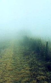
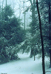
forethought of the hand we're about to be dealt. |
| The trail ascends eerily into the
fog. |
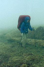
|
| It's not as bad as it looks. It's
worse! |
|
2/22 Little Bald campsite to Erwin TN (14
miles)
"I sift the snow on the mountains
below,
And their great pines groan aghast;
And all the night
'tis my pillow white,
While I sleep in the arms of the
blast."
Percy Bysshe Shelley, The Cloud We're
surprised at 03:00 by the patter of rain on the roof, and before
falling back asleep it turns to what sounds like ice pellets. When I
wake to find some light at 6:43, the tent walls are dry, but the
roof bulges inward under a heavy load - I believe my exact words
were, "Hon, you ain't gonna believe this". On unzipping the door
we're both shocked - a full 5" of snow cover the ground, still
falling at a good clip, whipped by an east wind that portends a
major storm. We both lay back for a good laugh - so much for our
flawed expectations. |
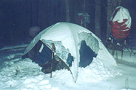
|
| Not at all what we'd expected after a
beautiful clear sunset |
|
But now it's down to the
drudgery of deciding which of our meager clothing stock will best
get us down to civilization and how to get breakfast
without getting soaked. I begin outside, dropping the bear
bag, bringing the stove in, and digging the packs from
underneath mounds of snow (good thing we put on the pack covers).
Coleen gingerly starts the stove in the tent (a huge taboo in
camping circles), and soon we have breakfast, coffee and enough
melted snow for drinking water.
It's a
laborious process, but eventually we drop the tent
and get underway, finding it a winter wonderland out, spectacular in
appearance, but tougher hiking than normal (for me, that is; Coleen
just steps in my compressed footsteps). It's exhilarating hiking,
though we're disappointed in a bit to find another gap and
campsite exactly meeting the description of Whistling Gap -
obviously we stopped too soon last night. After passing High
Rocks, a massive rock formation, we begin the continuous
descent to Spivey Gap, passing through beautiful snow-laced hemlock
and white pine stands. The beauty of the trail is magnified by this
rare enhancement, and we entertain ourselves with the animal tracks
(only one deer, but many tracks of walking birds). Some attention is
required to stay on the trail, but this is more than compensated for
by the fun of laying down the first footprints on this field of
virgin snow. |
| Good thing we didn't decide to sleep
out under the stars |
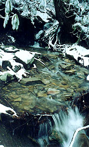
At Spivey Gap, we find the
road plowed, but devoid of traffic, and we begin the climb along the
beautiful Oglesby Branch, pausing at the first bridge for a break by
some striking cascades. We continue upstream, finally reaching the
top, followed by a gradual descent as we bore on towards our
lunchtime goal - No Business Knob shelter. We're slowed as the
snow underfoot becomes slush, along with the path's slabbing of
steep slopes, made more treacherous by the wet layer of dead leaves
underneath. Finally our descent ends with a moderate climb to the
shelter - dirty, dark, and occupied by a solitary hiker crouching in
his sleeping bag working crosswords. Attempts at communication with
him yield few results (he's southbound, having started in Mass, and
is taking a day off here to "dry" his soaked gear), so we quickly
eat our lunch and move on.
He's a little creepy, and we're
glad to be closing the final 5.7 miles to our goal. The slush and
snow rapidly diminish (we follow a set of raccoon tracks in the
path's center that last a solid quarter mile), and shortly after Temple Hill Gap
the ground is almost clear. Here the massive downhill
into Erwin begins - those who have gone before us all comment on how
elevator-like the descent is. I wouldn't know. Ours is shrouded
entirely in cloud - we hear the roar of traffic for miles, but all
we see is gray in every quadrant.
Suddenly we descend beneath
the cloud deck, and though it's still drizzly out, the view is
nothing short of awe-inspiring. From our lofty perch, it is
absolutely straight down to the Nolichucky river far beneath - none
of the hillside below can be seen; just a cliff, then oblivion. It's
incredible, and the excitement of this wondrous vista inspires us
for the final descent. Soon we're making our final switchback and
Uncle Johnny's comes into view, though our red Eclipse is nowhere to
be seen. We find the hostel closed, but a phone call
to Johnny produces it momentarily. Although we'd planned on staying
here, opening the hostel for us two seems a bit much to ask, so we
seek the comfort of the nearby Holiday Inn Express, which also has a
hot tub.
The big surprise comes as we're checking in, seeing
on the lobby tv the story of this major winter storm we've just
endured, having closed the schools from here all the way up the
eastern seaboard, and resulting in a 114-car pileup just south of
our home. After showers, an email check, and some town food at the
suggested Erwin Burrito, a small Mexican café, we do a quick search
for information on the infamous elephant hanging, the gist being as
follows: |
|
| It's so much fun putting the first
footprints down the trail! |
|
|
In 1916 a mistreated elephant killed its
trainer in the circus in Kingsport, TN. The elephant was shot "half
a dozen" times with small caliber rifles with little effect. The
citizens of nearby Erwin, on the circus's intended route, took up
the challenge at the railroad yard. First to the power plant to
electrocute the beast, an abysmal failure, followed by an attempt at
hanging. A crane and chain hoist was erected but as the rogue
elephant was lifted, the chain broke, resulting in a broken hip, and
a more incensed elephant. The chain was reapplied, and the
subsequent hanging brought about the beast's demise. It was a major
community event and many of the townfolks' grandparents were there
in there "Sunday best" as everyone brought their kids out to witness
the event (many feel the electrocution account may be contrived,
though).
After a relaxing and comfortable evening, we find
yet one more bit of quintessential trail lore before leaving town.
On checkout we meet the well-known Miss Janet, a trail angel of whom
we've read in numerous journals. We chat of barefoot hikers, of "The
Family" (a family with kids aged 2-12 just finishing the trail), of
our friends Caveman & Spike, of the incoming Uncle Shoe &
Chili Mac, and countless others. She knows virtually everyone that's
hiking or have hiked the trail, and fills in quite a few gaps in our
curiosity about hikers we've read in the registers. Although we've
now completed the trail both ways out of Erwin, we're glad to have
made her acquaintance, and will look forward to hearing of her aid
to our fellow pilgrims.
| |


