Return to Elation
¤
Unbridled wonder comes with
a warning
Newfound Gap (Smoky Mountain NP) - Hot Springs,
NC
The southern Smokies re-introduced us to the solitude of trail life last year after all the
affairs of 9/11, and their northern half comprises our only remaining section of NC/TN yet to
hike. Their 6000'-plus altitudes often pose severe weather challenges even in April or May,
giving us pause before making them our November hike. Still, the forecast looks possible, and
with our good fortune the previous two months,it's time to connect the dots.
|  |
|
11/13 Newfound Gap-Tri Corner Knob Shelter (15.6 miles)
"The trees were like lace where the star-beams could chase,
each leaf was a jewel agleam.
The soft white hush lapped the Northland and wrapped
us round in a crystalline dream"
Robert Service � The Ballad of Pious Pete
The northern half of the Smokies is marked by dense spruce and fir forests and high-altitude
ridge walks (a welcome relief from the endless climbs in the less-scenic southern section). The
animal life is fairly similar, although by November the bears have migrated to the lower
elevations, so there's little chance of a sighting; but we've still eagerly anticipated this
section. Our shuttle is arranged with Elmer - a past thru-hiker and owner of a popular hostel in
Hot Springs, NC; pulling into his place mid-morning to find the guys chatting in the kitchen.
Here we meet Paul, our shuttler (another thru-hiker on a work for stay), who leads us over to the
Hot Springs trailhead to deposit our car before climbing into his beat-up, trash-receptacle of a
car for the ride to Newfound Gap. Paul ("Train" 2002) started his thru-hike this spring, but got
bored with it in North Adams, pulling out to return next year (perhaps $$ was a factor too,
having started the trail with only $500 saved up). He intends to go hiking in the Smokies today
as well, hoping to see snow (which he's never seen in his FL childhood).
|
 |
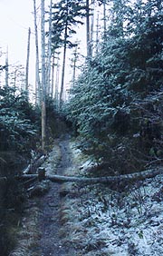
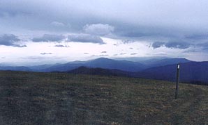
| Looking cold at Newfound Gap
|
|
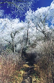
As we finally near Newfound Gap, we find the trees here at high altitude are all
coated thickly with frost from last night's thick sheet of cloud, making a stunning backdrop
against the rapidly clearing blue skies. As we unload our packs, we find the parking area
typically littered with shivering tourists - not only do we get lots of funny looks out here in
our shorts, but almost everyone feels obliged to either ask if we're cold or to take pix and
movies of us. After a quick run through the bathrooms, we emerge into this winter wonderland,
though the few hikers we pass feel obligated to advise that we're soon to be assaulted by the raw
wind on top (maybe we're accustomed - it never seemed that bad). It's great hiking on easy path,
though we're slowed by the numerous photo opportunities, having to force ourselves onward through
this winter wonderland. Our first break is at the Icewater Spring shelter, one of the first
shelters in the Smokies to remove the classic bear cages (intended to protect hikers, but often
encouraging the reverse effect, where hikers to stand within the safety of the cages and toss
food out to attract bears for pictures). It's a new and spacious shelter, with a couple
short-term hikers here, but we've miles to go, returning to the winterscape as we pass Charlies
Bunion, although one of the hikers here assures us it's not worth taking the side trail to the
rocky outcrop itself.
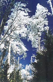
| The Smokies at their best
| |
| We hike on elatedly through the chamber of
wonders, passing Peck Corner shelter for a climb up Mt Sequoyah, where the soft glow of sunset
bathes the snow-covered firs for the evening's final picture. With headlamps on we continue
through the beautiful moonlit night, finally pulling up to the standard Smokies shelter at
Tri-Corner Knob. We're a bit surprised to find Mayor and Apple Jack (Southbounders) already
here, spread out across most of the shelter, but still up. We chat for a few minutes, making a
space under them on the slightly claustrophobic bottom bunk; dining on our dinner sandwiches and
hot drinks before turning in at 10:00.
11/14 Tri Corner Knob - Standing Bear Farms (18.1 miles)
"The man with the knapsack
is never lost. No matter whither he may stray, his food and shelter are right with him,and home
is wherever he may choose to stop.".
Horace Kephart - Camping and Woodcraft
|
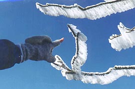
|
| An astounding 2-3 inches of rime ice on the upwind side
of each branch
|
|
It's a good night's sleep - no mice and warm enough that we each shed clothes throughout the
night. We're up at 6:30, making a quiet breakfast as the guys sleep in, and hitting the trail
early for another beautiful morning (though the first hints of cirrus clouds already float
overhead. Though it's a cold morning (seems a hint warmer than last night), we see almost none
of the rime ice that filled yesterday's pictures. The spruce & fir forests are still spectacular
though (only a few patches killed by the woody adelgid - not nearly so many as we'd been led to
expect), and the path is over a narrow walkway with plunging hillsides just inches to either side
- equally stunning. Our early lunch is the Cosby Knob shelter, a decent shelter, which oddly has
a large piece of a light airplane tail fin lying here, remnant of a long-ago crash nearby.
As we resume our woodland trek, the hard-frozen trail starts to soften, now beginning the mammoth
descent towards the park's end at Davenport Gap. The conifers give way to hardwoods, coating the
path with noisy, crunchy leaves that often hide rocks and roots underneath. Several
Southbounders pass, including Walking Wounded (we've run into him somewhere before) and
Driftwood; and later Phil gives us an enthusiastic report on Standing Bear Farm (along with an
equally unenthusiastic report on Mountain Mama's, which most now hold in low esteem). Armed
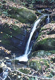
thusly, we forge on past Davenport Gap (end of the Smokies), following a beautiful creek
surrounded by autumnal color as we desc to I-40. We cross under on Waterville School Rd, which
we also know to be our destination for the night, although the trail architects have a cruel joke
in mind for us. Instead of the easy roadwalk up to Standing Bear, they've chosen an incredibly
steep trek up the adjacent slope, winding up and down for the next mile through a series of
switchbacks before returning us to the road a mere 200 yards from Standing Bear. We follow the
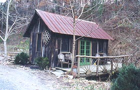
directions to the farm, finding it to have a quaint, outdoorsy look, although no one save one
fairly tame Rottweiler senses our arrival.
After knocking on the door, Kurt appears, a bit surprised at our arrival, dressed in the
coveralls / no shirt motif. He walks us through the facilities, all of which are outside (and
we're already freezing, having sweated on the former climb and now standing around in our wet
clothes). We're further disappointed to find that neither the bunkhouse or the cabin have
electricity or heat, both very dark in the fading light, although we quickly choose the cabin, so
as to at least have a bed. It's situated directly over a brook which Kurt says keeps some folks
awake, though it sounds soothing to us; and we're now anxious to get some water heated for dinner
and hot drinks; and get into some warm clothes. It takes a little work to get rid of the overly
helpful Kurt, who insists on building a fire (even though we'll never go over to use it), and
turning on the hot water for the outside showers, although with no way to warm up afterwards, we
decide against these as well.
Finally we get a kerosene lantern and some candles lit for a bit of light, having our dinner in
the cabin as we try to warm up with a couple rounds of hot drinks. I head over to ask Kurt about
the advertised internet, finding that there's a laptop out in the laundry room that actually
works for said purpose, although the need to remove one glove to work the touchpad makes for a
quick session. Kurt's tried hard to make this a hiker �friendly place in the year he�s been in
operation, although all the hiker amenities (fireplace, showers, laundry, fridge, microwave,
internet) aren�t terribly useful in the winter. It looks like there are sufficient covers on the
bed to keep us warm though, and after securing our food from possible mouse attack in a hiker
box, we turn in at 8:48.
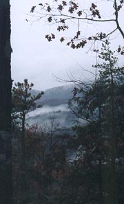
|
| Starting out on frosty trails |
|
| A final bit of scenery as we leave the Smokies
|
11/15 Standing Bear - Roaring Fork Shelter (18.5 miles)
"If you don't know where you're going, you'll end up somewhere else."
Yogi Berra
|
| I sleep like a log � Coleen less so,
getting cold during the night and abandoning me for her sleeping bag. We�re up at 6:24 for our
standard breakfast fare, although it�s nice to be able to nuke my Poptarts and Coleen�s bagel for
a change. It takes a little work to find Kurt and settle up with him, but finally we�re off,
beginning with the massive climb out of the gap. The clouds are already moving in, with rain
predicted tonight, so we�re highly motivated to make it to the Roaring Fork shelter, even though
it would mean our 2nd 18-mile day in a row - this one with almost 5000� of climbing. The climb
begins immediately up Snowbird Mt, with 3 stutters enroute, though the trail is well-graded and
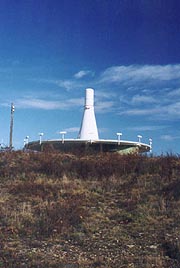
switchbacked the entire way, enabling a steady pace all the way up. Atop, the forest opens to
reveal a meadow, with an odd structure here I know to be a VOR (a navigational beacon used by
airplanes). We�re due a break, and needing shelter to stave off the cold east wind, I suggest we
take our break on the sheltered side of the VOR building. There�s a small fence around the
transmitter, with the usual draconian warnings against tampering and such; but it looks harmless,
so we do (hope there's no video cam here).
|
|
| Our rustic cabin at Standing Bear, complete with
stream underneath
|
|
From here the path turns back downhill to Deep Gap (how many of these are there on the
AT?), stopping shortly after for ourlunch break before the 2nd big climb of the day � the gradual
one over Max Patch. We�ve been hoping the entire trip to complete this portion in good weather,
being our last crossing of a genuine southern bald (most of which we've crossed deeply encased in
fog). It�s a race against time though, the clouds thickening and lowering all day; but as we
approach, it looks like we've made it, the large bald green summit visible from miles away.
Finally we reach its base, where the trail winds gradually around, with the typical blazes on
posts to mark the trail in low-visibility conditions. It�s a beautiful bald even in these cloudy
conditions, and we�ve barely reached its windy summit as the first drops of rain start to fall.
We hurry on to the safety of the woods to don our jackets and such, entering a thick rhododendron
grove reminiscent of a dark but well-groomed corridor. Here we�ll pass the southbound Mohican,
Angel,and Scott, who linger a while to ask us our opinions on the upcoming Smokies and such. We
wish them well (they�ve got tough weather ahead), and head onward, the trail joining a road
through a fat-man�s squeezer.
A blaze confirms the direction, but soon we reach a fork in the road for which neither side is
blazed. A search of our paperwork selects the most likely fork, but moments later we find it
quickly disappears in the woods. A further Search reveals we were to have crossed a logging road
at the stile, and heading back we find this true, the "blaze" we�d followed being merely a scar
on the tree of exactly correct dimensions. Back on the right trail, we scurry along, our chat
with the SOBO�s and our wanderings threatening to put us into the shelter after dark. Indeed,
darkness falls quickly under the cloudy skies; and the rain increases, with Coleen putting on her
headlamp as we�re wandering through the woods looking for the shelter. As the path winds up one
of the tributaries to Roaring Fork, we see lights in the bottom, which must certainly be the
shelter, Sure enough, when we get on the other side we see them again, reaching the shelter
moments after.
| A VOR (aviation navigational beacon) becomes our lunch
shelter |
As we approach we find the "10-man" shelter totally filled by two large tents � one completely
filling each side. While tenting in shelters is not expressly forbidden, it's a rookie breach of
etiquette (an AT caveat is that on a rainy night, "the shelter�s not full till the last man�s
in"). The couple in the tent on our left (let�s call them �Gary� and �Betsy�) offer to move
their tent outside, still not sure if they�ll sleep inside or in the tent yet. It sounds good to
us (especially since Coleen�s beat beyond description, and there�s yet been no sound from the
tent on the other side). We find Gary and Betsy from Knoxville, herself a nurse like Coleen;
although an unlikely couple for the trail, him quite rotund and both of them heavy smokers. Soon
Mary emerges from the other tent with two dogs of hers, out for her first night in the wild.
They�re all pretty nice folks, and we busy ourselves with dinner and hot drinks, though still
unable to set out our gear as the platform we�re on is still covered with Gary & Betsy�s stuff.
They finally cook their dinner about 8:30, a lengthy process after which we chat for a bit before
they decide to read through the shelter register, leaving us sitting there waiting for them. By
the time they clear their gear out it�s 10:00, and they�re out in the tent talking loudly until
11:00, when we can finally attempt sleep.
|
|
| Max Patch, the AT crossing on the right - our last
natural southern bald
|
11/16 Roaring Fork - Hot Springs - Home (14.9 miles)
"Take long walks in stormy weather or through deep snow in the fields and
woods,
if you would keep your spirits up. Deal with brute nature. Be cold and hungry and
weary."
Henry David Thoreau
|
|
It's a dreadful night for sleep, between our late turndown, the balmy temps, Gary's mighty
snoring, Mary taking the dogs out in the wee hours, and Betsy needed a smoke break around 5:00.
I never get back to sleep after the latter, soon finding Coleen awake and agreeable for an early
start. We quietly prep in the pre-dawn rain, starting with a march up Walnut Mt, with Coleen
starting to lag early due to knee pain. I stop for her at the small shelter atop to see if she
needs any wardrobe adjustments, only to get a lecture on my snippy attitude, so it's obvious it's
going to be one of "those" days. We pass a couple northbound section hikers heading up Bluff Mt,
finding them going from Max Patch to Hot Springs, having camped out a couple miles past us last
night.
Climbing Bluff Mt we're doing surprisingly well, Coleen making good speed going uphill, but
slowing to a crawl on the downhill, with considerable pain on her right knee. It's a long
but well-graded descent, and we're glad to find a small cave in some large rocks where we can
barely get out of the rain for a few minutes. We have a quick break here, donning warmer clothes
as the climbs are behind us (including my stocking cap and thick gloves for us both). We resume
the featureless descent, though we finally get a view of the valleys off to the sides, each one
filled with cloud below us. Still, the path soon levels, and minutes later we cross Garenflo
Gap, making good time - there's a short but steep hop over Lamb's Knob that we're both dreading a
bit, but it turns out such a non-event that we can only surmise the trail's been relo-ed around
the summit. We're not sure for some minutes afterward if we're really crossed it, but as the
descent continues gradually we're soon convinced, pressing on towards our final stop at Deer Park Mt Shelter.
| We've finally finished the 'smokin'
Smokies | |
It's a bit further off the trail than we'd imagined, but on arrival we find the two guys from
this morning having a pot of chicken noodle soup (looks great in the cold rain). They've decided
to continue to Hot Springs as well, and after a quick break we head back for the final leg.
Leaving the cloud level I stop for some pix, sending Coleen on ahead, though my lens fogs over
quickly, with nothing dry to clear it. By the time I'm done, I practically run down the trail to
catch up with her, finally catching up just above the town of Hot Springs. By now the rain has
stopped, and she furnishes a tissue to clean my lens for my final shot before I beat feet for the
car. We pass a couple of southbound coeds (obviously just cleaned up at Elmers) climbing out,
and I get to the car at 2:50, having just changed clothes when Coleen arrives :10 later. I think
it was Bryson who said the AT is a lesson in low-order ecstasy, and today is the living proof. A
warm car, a hot meal, dry clothes - the joy of such things on the AT far exceeds all belief. We
revel in the delights of civilization as we set our course for home, the Smokies finally behind
us. Now, to turn our sights northbound!
| |


