When it Rains, it Pours!
¤
with a mean, vindictive spirit
Daleville VA to Dripping Rocks Picnic Area (central VA)
We're narrowing down the miles left to Katahdin, with the only remaining section south of Vermont being our remaining 120 miles in VA. I've got plentiful time awaiting the completion of my training in the new aircraft at work, making the long mileage well within our time available. The weather report is dismal however, with thunderstorms forecast every day of our time allotted, combined with scorching temps. Furthermore, the main thru-hiker push should be in the area, meaning the shelters will be full beyond capacity. Still, it's Virginia - how hard can it be? How hard indeed!
|
6/11 James River – Brown Mt Creek Shelter (19.3 miles)
"In order to live free and happily, you must sacrifice boredom. It is not always an easy sacrifice."
Richard Bach - Illusions
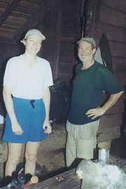
The proximity of this section to our home allows us to forego the usual shuttle drill, doing it ourselves in our own two cars. As we hiked last month's hike in Maine, an ingenious scheme was hatched for doing this - by starting in the section's center, we'd arrive back at one car in the middle of our hike, allowing a town night and resupply before the latter half. Logistics suggested we start at the James River, hiking north to the section's end, thence concluding by driving south to Daleville to hike the southern half north back to where we'd started. It's a little unconventional, but this has become our forte lately, as we set off early to spot all the cars in appropriate places.
|
|
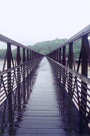
| The James River Footbridge - our beginning and end |
|
Our day’s gradual climb starts at 11:05 as a couple hikers climb down off the footbridge seeking a hitch; and we're immediately impressed with the ease of the trail and the gentle grade thereof. It’s a nice forest walk, even as we begin climbing in earnest, though the summer heat quickly takes its toll, leaving us sweating rivers. Coleen slows, and we’re both hungry, so a quick snack break spurs us on. At Saltlog Gap we come across our first thru-hiker – Sleepy Floyd, a late starter living up to his trail name, suffering badly from the VA blues (considering coming off the trail). A quick hop over Bluff Mt is followed by a descent to the Punchbowl Shelter - we’re due a break, but it looks a ways off the trail, so we continue down to the Blue Ridge Parkway crossing for a quick break on the curb.
As we do, the ominous sounds of thunder suggest we continue, a light rain soon giving way to a full-fledged thunderstorm. We’re safely below the ridge so we continue over a few speed bumps of Rice Mt, starting down to the Lynchburg Reservoir in the now-pouring rain. Following Little Irish Creek downhill, we cross a bridge across of which sits a pickup and camper, surrounded by coolers, tables, and cooking gear. It's Renegade and Tomboy, offering trail magic to hikers in the form of dinners and breakfasts. It’s raining far too much for this, but they have Cokes and cookies, which really hit the spot on this steamy day. After a nice chat and a small donation we forge on, coming moments later to the Pedlar Dam on the reservoir. The water surges over the dam with a hypnotic effect, towering above our tiny footbridge at its base. After a couple pix, we resume the chug around the reservoir, though the trail quickly turns to an orange mud in which we slide one way or the other with every step. It’s tough going, but finally we re-enter a more solid surface in the woods, the level path taking us on to our destination – the Brown Mt Creek Shelter.
|
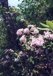
| Mountain Laurel are plentiful and in bloom |
|
The creek (like all we've seen) is surging to the point we're unsure if we’ll sleep over the roar, and there’s an excellent (if highly-sloped) campsite on the near bank, although we have to cross on a pair of logs to arrive at the shelter. Atop the small hill we find the shelter filled to brimming, counting 10 pairs of eyes in the 6-man shelter. They’re willing to try and make room for us, but tenting seems more in order, especially as the rain’s let up at this point. One tent's already up, and another is being set up across the creek; but a little search finds a suitable site on the shelter side, using a lull in the rain to get the tent up and retiring inside to consume the remainder of our dinner sandwiches. It’s muggy enough to dispense with hot drinks, though with the stream nearby it’s refreshing to wash up a bit and filter some cool water. We turn in at 10:30, but a party with loud laughter from Jen and others continues for over another hour before sleep's possible, drifting in and out until after midnight, by which time a pounding rain has begun.
6/12 Brown Mt Creek Shelter – Seeley-Woodworth Shelter (15.8 miles)
"I am not young enough to know everything."
Oscar Wilde
We’re up at 7:10, the tent having survived the rain high and dry, and after breakfast we pack up and head up by the shelter for a quick chat with some of the kids. We chat with Taba a bit before heading out, today’s adventure beginning with a continuous 3000’ climb up Bald Knob. It begins as a gentle forested climb that's quite pleasant, with a few historical markers concerning slave labor in the area. After passing VA 60 though (where Brew, Thirsty, and another girl are drying out there gear on the picnic tables), it changes to a steeper and grueling climb, the humidity and rising temps making it increasingly punishing. We’re going through our water quickly, and I’m starting to wonder if we’ll have enough to navigate the dry ridge ahead. Nearing the top I’m slowing considerably, finally needing to take a break on a convenient log for a quick bite and some extra water. This spurs me on to the top, where it’s a relief to turn back downhill, our big climb for the day over.
We take a break at the trail to the Cow Camp Gap Shelter, several of the gang joining us, a few taking the long walk down to the shelter for water. As we chat Oreo and Buttercup pass through, although Brew explains that they’re antisocial and won’t stop (backing it up with a $1 bet to Taba, which Brew wins). As we resume the short hop over Cold Mt. the sky clouds up, and soon I’m taking pix of the clouds whistling through between the peaks when my camera fails in a wholly unsuspected way. As I’m snapping a horizontal pix, it suddenly goes into full automatic operation, shooting off the entire 36-shot roll continuously, without even the off switch stopping it. This is alarming, but I can’t duplicate it without putting film back in, so I leave it for now as rain’s threatening anyway. We stop up ahead at Hog Camp Gap for water, a spring being located a couple tenths away; and soon the whole crowd joins us there in ine around the water hole. From here we resume our easy ridge walk to the Seeley Woodworth Shelter, seeing it across an open field of dying trees well before the shelter trail. There’s a trio of tents outside, a roaring fire, a small crowd of kids around, and Taba, who’d run by us on one of the downhills (we also meet the elder thru-hiker Hopeful here as well).
The kids are counselors in training from a small school in Hannover County, getting ready to bring some students out here hiking after this “dry run”. They’re getting ready to cook dinner over the fire, and between stories of the insects last night and the potential for late-night partying; we grab a tent site just behind the shelter. The rest of the crowd file in as we’re setting up, but soon the skies darken again and the rain begins – we barely finish heating our water for after-dinner drinks before it’s a genuine deluge. The kids try to stick it out outside in their rain gear as we watch from the shelter, but soon the fire’s smothered, their spaghetti a watery mess; and they all end up crowding into the shelter with the rest of us – probably 15 of us in the 8-man shelter. It lasts for over an hour, but finally I get bored, heading over to the tent to retrieve the maps and such; with everyone else fanning out a bit as well as it turns to mere dripping. We retire to the tent at 9:30, although the party in the shelter continues a while hence.
|
|
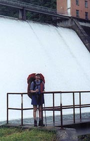
| The torrent surges over Pedlar Dam (Lynchburg, VA's reservoir) |
|
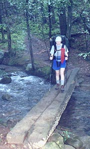
| Always good to have even a simple bridge in this rain |
|
| A "Hopeful" hiking companion |
6/13 Seeley-Woodworth Shelter – Harpers Creek Shelter (14.3 miles)
"In India, "cold weather" is merely a conventional phrase and has come into use through the necessity of having some way to distinguish between weather which will melt a brass door-knob and weather which will only make it mushy."
Mark Twain
We sleep pretty well after swabbing out all the water from last night’s deluge, though at one point we wake up as Coleen points out the full moon shining brightly on the tent fabric. We’re up at 6:30, finding Hopeful up and getting around quietly so as not to disturb the others. We’re off shortly behind him, quickly passing Porters Field where Oreo and Buttercup are getting around as well. During the short hop over Main Top I stop for a pix of the rhododendrons (the blossoms only remain on these higher peaks), but my camera problem returns, wasting another roll of film. I resolve to get a disposable camera on our town day and we resume the hike, which tops The Priest before beginning the long but gradual descent to the Tye River. As we take a break partway down, Hopeful comes hiking through, having stopped at the shelter atop to Yogi some food from a family out on a weekend outing. We end up hiking with him for much of the next couple days, finding he worked in Electronic Warfare for the Navy in Vietnam, having been and Engineer on the C-118, C-2, and C-9. The talk flows freely, and soon we’re crossing the long foot bridge over the Tye River, with a short 1000’ climb up to tonight’s destination – the Harpers Creek Shelter.
It’s a tough climb this late in the day with the heat and humidity, but easier having Hopeful to chat with, and soon we come on the rushing Harpers Creek, following it up to the shelter, with a rock hop to get across, the shelter itself perched on the other side. The radio indicates a severe thunderstorm watch, so we decide try the shelter; the thunder booming soon after, as I do a quick cleanup at the stream before the deluge begins. As it does, the hikers start coming by, with Oreo and Buttercup coming through first, actually engaging in a nice chat with us for a bit as they wait. Next it’s Llama and Doc, with their well-trained dog Coy, though Doc spreads across an entire half of the shelter entrance, not even moving when Risk comes in a few minutes, seeking shelter. Doc only perks up when Coleen joking suggests she’d pay for someone to fill the water bag (he only wants cash, not food), and it’s a bit of a relief when they head on, towards the Three Ridges in search of a tent site. Even Risk is a different sort, sporting a Boy Scout-looking shirt, an umbrella, an odd see-through plastic pack, and tennis shoes as he comes down the trail. He’s a nice guy (with medical and EE degrees), but he seems to have drank the company Kool-Aid on every gadget on earth, having built an Irish cooking pot for his stove, and sleeping in a hammock. As the rain slows he sets up close by and entertains us all with his cooking. Stonehenge comes in as well, a previous section-hiker in VA who’s now attempting a thru-hike, and once everyone’s fed, we all settle in early.
|
|
6/14 Harpers Creek Shelter – Dripping Rocks (13.8 miles)
"Good company in a journey makes the way seem the shorter."
Izaak Walton
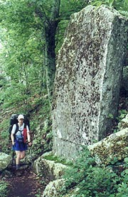
It's a big day today - our town day, when we're to arrive back at our car to shuttle down to the trail's south end. Couched in this glorious expectation, we’re up early with Hopeful, with our big climb starting immediately (though gradually) up over the Three Ridges Trail - this is a trail which grates on many hikers, requiring an extra three miles and considerable climbing vice the shortcut Mau-Har Trail between the two shelters. It’s really not bad though, especially as we near the top and pick up up some breeze out of the north, which may even herald drier air. At the first level-off passing Chimney Rocks, I snap a quick pix of Coleen passing one, and soon after I get one more chance at the rhododendron blooms, the camera apparently happy in its current state. We spy Coy sitting calmly off the trail side, with Llama / Doc’s tent adjacent, and soon we’re at the top, with fairly easy trail starting down.
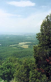
Soon Hopeful pulls up behind, joining us for a nice chat as we forge on towards our am break at Maupin Field Shelter. We pull in right behind one group of weekend hikers, with another group pulling in just after us; and on Hopeful’s finding them to be active duty service, he’s right at home conversing at length. Even as we leave he gives a long thank-you to them for their service, forging down the trail together at a brisk pace as we’re bound for the car. A couple crossings of the Blue Ridge Parkway find many weekend hikers launching here as we pass; and with the trail descends just below the parkway on the west side. The day turns steamy and the trail quite rocky for this piece, with Coleen slowing and soon needing a break. It works, as we pick up the trail again with renewed speed, making good time until arriving at Cedar Cliffs, running into a nice foursome of trail maintainers who Hopeful engages in conversation. He’ll be a while, so we say our goodbyes and head on, soon reaching the Parkway for a quick chat with a couple Southbounders and a couple parents waiting for “1/3” coming up from Rusty’s Hard Time Hollow (a nearby hostel).
It’s tough to tell how far we are from the Picnic Area trail, but it proves at least a mile. Just as we're questioning our navigation we reach a large sign at the trail intersection, where an elderly trio are equally lost in search of water. After filling them in we make tracks for the car, where our first priority is to find cold liquid refreshment (but not before passing the cutest young fawn by the roadside, still with spots and wobbly legs). Our first exit finds us an icy liter of Diet Coke, and with a little wardrobe alteration on the way, we feel almost civilized during our short return to civilization at the Roanoke Marriott Courtyard. With a shower, air conditioning, electric lights, a coffee maker, king bed, email, a steak dinner, and clean clothes, we're living in the lap of luxury once again. Now if we can only get back on the trail again tomorrow!
|
|
| Passing Chimney Rocks - finally, some breeze |
|
| A brief sunny overlook from Cedar Cliffs |
|
6/15 Daleville VA - Bobbletts Gap Shelter (18.5 miles)
"It comes down to a simple choice - get busy living - or get busy dying"
Stephen King - The Shawshank Redemption
It's been a wonderful night off - we actually enjoyed watching the evening thunderstorm pound outside from our comfortable room, but now it's time to resume the trek. We're feeling renewed as we rise early, stopping by McDonald’s for breakfast during the quick drive over to Daleville, where our hike is to resume. The Econo Lodge here is where we finished our inbound hike, and they allow parking for hikers. We load up the packs and head out in the misty morning, the initial walk taking us through a series of pastures that are exceedingly muddy. I’m trying out tennis shoes instead of boots for this section, and they’re soaked and covered with mud almost immediately. In spite of this, we make a solid 3 mph heading over to the VA 11 crossing, but still it’s a relief to return to the forest afterward, with a better footing as we begin the gentle climb up Fullhardt Knob.
The shelter atop is still filled with hikers not yet anxious to venture out into the rain, including Riffraff & Riffraff, Bluebird, and Puff Daddy. One of the Riffraff’s suggests his options are to sit around reading here or go home and get a job – an obvious choice for him. After a few minutes' break out on the picnic table we continue on the descent to Curry Creek, an easy rock-hop even in its swollen state. The rain returns, making the Wilson Creek Shelter a good choice for our next break, though there’s a pretty good crowd here as well – at least most of them are getting ready to depart. Moments behind us pull up Windsong, Trauma, and Yoni (their dog), and before we leave Bluebird and Puff Daddy pull up as well, although they've still got to filter water. We push on down the trail, intersecting the Blue Ridge Parkway at Black Horse Gap, although the trail just touches the Parkway before heading back into the woods, with the very rocky roller-coaster of a path just 100 yards or so off the nicely graded parkway. By our next crossing of same, we’re ready for a change, deciding to walk the parkway itself just over a mile to the next AT intersection. It’s a welcome change, though the lack of shoulders requires us to exit into the grass when the rare car passes – at least we can see out a bit and walk side-by-side.
|

|
Luckily, it's easy trail from Harvey’s Knob, getting us a few minutes early to the Bobbetts Gap Shelter trail, from which it’s .2 mile of switchbacks downhill to the shelter. Typical of all our rainy arrivals, it’s filled to brimming with hikers, but a foursome from Wilson Creek are moving on after a break, leaving just a couple of older fellows here. Finally we’re able to fend for a space - just in time too, as Windsong, Trauma, and Yoni (their mixed breed dog) pull in moments after, and we’ll quickly find they intent the dog to stay with us in the shelter. It’s not our first choice, especially as the dog shakes himself off all over all of us there without so much as an apology, and later, as the dog pukes much of his dinner on the shelter floor, which Trauma tries to wipe off the edge using a rock and later some leaves. Luckily we’re at the opposite end of the shelter, and the guys are both fairly nice guys, having met while hiking in Utah and deciding to do the AT together. Puff Daddy comes down to check the register, but finding Yoni here he defers to the next one (with Bluebird as well - they'd both had their fill of sleeping with the dog). We’re trying the addition of smoked tuna to a Lipton rice dinner, and it’s excellent, after which I head out to the picnic table following the rain’s end to work some crosswords and listen to the radio for a weather forecast (more of the same). The older guys retire without a word, and we follow their lead at an early 9:00, though sleep proves elusive, first the dog and the older guys snoring, and later the younger guys. We finally both resort to melatonin, finally getting to sleep at midnight.
|
| Still some rhododendrons blooming at higher levels |
|
6/16 Bobbletts Gap Shelter - Cornelius Creek Shelter (18.3 miles)
"On the same day all the fountains of the great deep burst open, and the floodgates of the sky were opened.
And the rain fell upon the earth for forty days and forty nights."
Genesis 7:11-12
|
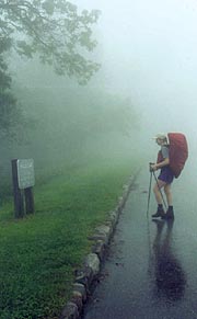
In the wee hours a pounding rain returns, still pouring as we rise in the semi-darkness, with very little inclination to get going. There's little hope of a reprieve though, so we're away just after 8:00, with a fairly level trail to Bearwallow Gap, where the AT diverges sharply from the Parkway. The rain remains torrential most of the day, but at least the trail is easy as we squish our way to the Cove Mt Shelter for our first break. Here are the group of guys who continued on last night, having tented in a flat area below the shelter that now resembles a small pond. One of them departed his tent this morning to find a Copperhead waiting outside, and all their gear is completely soaked from the unexpected rain last night. It’s a long break as they get away and we catch up on our maps, but finally we’re back to the uneventful and rainy trail, with little of note until reaching the Bryant Ridge Shelter for a late lunch break. We’d heard this was a beautiful shelter, but words don’t do it justice, with three stories, the lower of which sporting a picnic table and a spacious foyer under roof, with two sides open and airy, and ample windows. Unfortunately, it’s too far for us to make the car tomorrow, so we grab a break here as the rain abates and the other hikers head down the road.
|
|
Once fed and slightly restored, we begin the trudge up Floyd Mt, a 2200’ climb, but a gradual one, with a couple of stutters along the way, and eased considerably by the cooler temps today. A couple hours later we're atop, with a short descent to tonight’s destination – the Cornelius Creek Shelter. As expected, there’s a crowd here hiding from the rain – most of them the group we’ve been chasing the last two days. They’ve put up a number of clotheslines and are trying to dry off everything they own outside, although one of them (Lloyd) seems bent on staying, his sleeping bag perched in the midst of the only spot in the shelter devoid of leaks. On the shelter’s other side we meet Crossroads, a long-distance section hiker a bit older than the rest of the crew and surprisingly normal. Lloyd, on the other hand, seems pretty ill-mannered and clueless; so it’s quite a relief after about an hour when the group moves on and he decides to follow the herd. I’m still expecting Windsong, Trauma, and Yoni to come through, but we never see them, settling into a blessedly uncrowded night for a change with Crossroads. With the end of the rain we could almost start a fire (were there any dry wood about), but instead we have an easy evening of dinner, a couple of hot drinks each (it’s turning cooler, with a continual wind blowing across the shelter’s front), turning in at an early 9:00.
|
|
| Crossing the parkway in the typical torrential rain |
6/17 Cornelius Creek Shelter - James River (19.9 miles)
"Be very careful what you set your heart upon, for you will surely have it."
Ralph Waldo Emerson
|
I’m pretty cool overnight despite wearing Coleen’s flannel shirt, but I finally get up and pull the rain fly over as a cover, finally getting warm enough to shed some clothes before dawn. We’re up early, but as we quietly get around Crossroads comes to as well, the morning filled with birdsong in spite of the continuous rain which has been falling for several hours. Coleen’s starting out in her jacket in view of the rain and the moderate southeast wind, but I’m gutting it out in short sleeves, heading out just behind Crossroads. Our final trail day begins with a few ups and downs before the 1000’ climb over Apple Orchard Mt – at 4225’ it’s the highest mountain northbounders will see until Moosilauke in NH. We scare up a small fawn crouched near the trail against the rain, but otherwise there’s little to be seen, with the clouds quickly obscuring all views down to 100’ or so visibility. As we emerge onto Apple Orchard’s bald summit, a raw wind rips across, and we pass a small assembly of lighted buildings (once the site of an Air Force radar station with barracks for 250 men) including an almost unseen tower mounting eerily above us in the cloud. It’s a relief to come back down off the summit, and I make a final attempt at capturing the beauty of the rhododendrons, although my camera re-enters its demonic state, consuming the entire roll again.
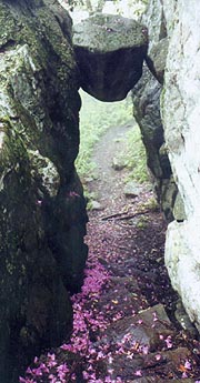
This proves especially unfortunate as we soon pass the Guillotine – a precariously perched rock above the trail that’s one of only 3 places on the AT where we’ve walked under a rock. It’s worth putting another roll in, and after the pix it’s a quick hike over to the Thunder Hill Shelter, where the usual gang ahead of us is slowly vacating the shelter. We break here slightly out of the rain, entertained by a couple of the druggies in the rear of the shelter including such gems as – “Our goals for today are: 1. Get some weed, and 2. Hitch into town.” and “I go wherever the path leads – don’t care where those white blazes go.”. This along with some diatribe on how they’re going to sue the oppressive government soon wear on us, so we head back to the trail, roughly following the parkway as it descends to Petites Gap, the final intersection of the two. From here we bear left away from the parkway, with a few speed bumps left on the gradual descent to the James River. We’re forging ahead at a good pace as we anticipate our car, although a time check at the Sulphur Spring trail proves wildly optimistic, making me suspect an error in the Data Book. Worse, at this point the blazes disappear, causing us to suspect our route, and finally pull out the map. The Balcony Falls Trail roughly parallels our route for a while, and we suspect we’re on it, but finally we come to a blaze – for some reason the maintainer in this section only puts them about one every Ľ mile. Subsequent trail crossings confirm our timing, and as we recross the Sulphur Spring trail, we run into Crossroads again, taking a quick break.
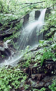
From the final shelter (Matts Creek), we continue down the surging Matts Creek, with the trail turning a mile later to follow the brown, brimming James River. I’m driving on quickly towards the footbridge, and Coleen falls behind, though she passes me as I stop for some final pix of a waterfall here and of the footbridge. The mosquitoes are out in force here, so I hurry through my pix and head for the footbridge, with a very confusing intersection of the trail just prior, but finally heading across the final span. This is the longest footbridge on the AT (625’), and on the other bank Coleen’s already loading the car and changing her clothes, so I quickly throw my pack in the back, grab a few clothes to change into myself as we head towards food. Our longest section is finished - all that stands between us and Katahdin is 138 miles in NH / VT, and the 100-mile wilderness in Maine. Our goal is almost in sight, and we're tired, but elated!!
|
| The 'Guillotine' - one of the 3 places on the AT where we’ve walked under a rock |
|
| One final waterfall along the brimming James River before our hike's end
|
|


