A Bridge Too Far
¤
Should a man's dreams really exceed his grasp?
Bellvale NY to Delaware Water Gap
NJ
As spring fades into summer, our thoughts turn
north, the NJ section coming to mind. With its many swamps and bog
bridges, it's a good segment to get done before the mosquitoes come
out in force. With the
excellent weather we've enjoyed on the last several segments, I've
always told Coleen that some day we'd hike an entire section in rain
every day; but she writes me off as a pessimist. She'll be found
wrong.
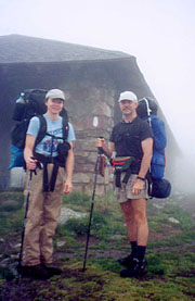
5/20 Bellvale NY -
Waywayanda Shelter (9.9 miles)
"We must never be afraid to go too far, for success
lies just beyond."
Marcel Proust For logistic reasons,
we'll hike this section from southbound, our car left at
Delaware Water Gap (on the NJ/PA border), and a shuttle up to
the NJ/NY border to begin our hike. The drive
to DWG is easy enough until crossing the Delaware, which proves
about as difficult as it was for George Washington himself. The
planned exit (another of those "you can't miss it" deals)
eludes us, and already short on time, we're well past before finding another.
Even when we find it, we have to
backtrack down a one-way road to get to the ranger station where
we'd agreed to meet our shuttle, Barbara.
There's no sign of her yet, so
we sign in with the rangers and unload in a light rain.
A few
minutes later she pulls up in a red VW Jetta, resembling the
aftermath of an explosion in a homeless shelter. The interior is
strewn with trash, the exterior similarly distressed, and Barbara
herself is probably not among Time's 50 Most Beautiful
People edition. She is quite jovial though, and after profuse
apologies, we toss our packs on the garbage heap in the back
and we're off. Barbara could easily talk the entire 80
mile trip, enlightening us on her job as a teacher and on the
sections of the AT she's hiked. From her bulk and the extent of her
nicotine addiction it looks doubtful, but she's well enough informed
that it's obvious she's done it, even if not at a fleet pace. A
quick stop enroute gives me a bathroom break and Barbara the
necessary Twinkies, and we proceed, hearing of her trail name (The
Boss), acquired during a shuttle given by an inebriated waitress in
Pearisburg. (She convinced their host that only by driving
herself could she avoid car-sickness, and thus saved both riders
from terror or worse). Approaching Warwick Turnpike, she questions
our decision to start there, convincing us of the wisdom of
continuing to Bellvale NY, a more common start. Coleen's sold that
the extra 9.5 miles is a worthwhile investment, so Bellvale it is.
Here we unload, tender our
payment, hear her evaluation of how great the NJ AT is, and we're
off (3:05). It's still very misty out, making a good day for our
return to the woods, with all the aromas of the wild at full
intensity. The woods are full of rushing streams, and soon we ascend
the ridge overlooking Greenwood Lake - it's long, with plunging
forested ridges to either side, much like the Finger Lakes of NY;
and would be of stunning beauty in good weather. Now it's barely
visible, our route
continuing on the rocky spine of the ridge, with
cloud and fog periodically blowing across to obscure all but a few feet
around us. We pass a couple girls heading north on a week-long hike,
and also pass the scent of a skunk for a short ways.
Soon
the NJ state line passes underfoot, and passing Warwick Turnpike, darkness
falls quickly in the fog (we're startled momentarily as we
flush out a deer from the underbrush). After only one wrong turn we finally
find the shelter path, marked by an invisible blue blaze in the
shape of a lean-to. A short hike uphill finds our lodging, and
Coleen expresses our good fortune of having the shelter to ourselves.
It's short-lived however, as our flashlights reveal a tent erected
inside the shelter on the left, and a hiker in a sleeping bag on the
right. Both occupants are awake, and from within the tent orders are
barked at us about use of the bear box (a NJ alternative to hanging
food away from the bears). We can't get a sound or even a name out
of the hiker on the right - we'll later find him to be Warren, whom
I originally suspect to be mute.
Throwing our packs
outside we get dinner started, served by candlelight
on the wet seats of a steeply sloping picnic table in the mist. We
won't physically see the tent occupant until morning, when we'll find her to be
the aged Elderberry, with quite a reputation on the trail. Until retiring, she
continues to bark orders at us from behind the tent
fabric, reminiscent of the Wizard of Oz; and even then we're
serenaded by her snoring, as varied in tone and quality as the
birdsongs we listen to each morning. Some of the timbres are new to
us both, evoking some chuckles as we turn in at 10:35.
5/21 Waywayanda Shelter - Unionville Hostel (18
miles)
""Two and two are four. Sometimes, Winston.
Sometimes they are five. Sometimes they are three. Sometimes they
are all of them at once. You must try harder. It is not easy to
become sane."
GEORGE ORWELL - "1984" |
|
|
In a perfect world I'd wake to the
sound of my wife gently singing sotto voce, the smell of
bacon and coffee wafting about. In our world however, it's a
pounding on the floor on which we sleep that rouses us at first
light. It's Warren, hammering duct tape patches onto his stuff sack
with his fist just inches to my left, raising his fist high above
his head to get a good swing at it. His fist must ache, as the
shelter shakes with each impact. Now
we're all up, and we attempt to converse with Warren, getting at
best a mumble or a monosyllabic answer. After breakfast, we're
ready to go when Elderberry suggests a trip to the visitor's
center (.4 miles away) for water. As all the water we've seen has
been tinted brown, it seems worth the walk, finding it shorter than
we thought, though the center's not yet open. We
find the tap nearby, and soon we're back to the shelter, where after
an extended lecture by Elderberry on the need for 2 hiking
poles and her opinion of the upcoming accommodations, we're off
at 07:45.
It's a pleasant walk in the morning mist,
the forest paths giving way to the mix of forest, road,
and meadow; and we cross many of the stepstiles and stone fences for
which NJ is famous (it's said that NJ has as many rocks as PA,
they're just piled up into fences). At low elevations the bugs
attack mightily, and we begin our test of light swabs of DEET along
with the Bounce sheets on each of our pack straps, which holds
them at bay (Note to self: never store toothbrush in the same pocket
with Bounce sheets). Before the easy meadow trails however, we have one
more assault on Waywayanda Mt. Approaching the top, a side trail to
Pinwheel Vista promises stunning vistas, but for us it's nothing but
fog and cloud in every direction (the western face is immersed in
cloud, with only 20-30' visibility). It's beautiful in its own way,
with majestic rock faces looming ominously from the fog; and it
proves a steep climb down, with steps provided, - even a ladder in
one place. At the base the trail fans out across a field with the
escarpment disappearing into the cloud behind as we continue
across NJ 94. |
|
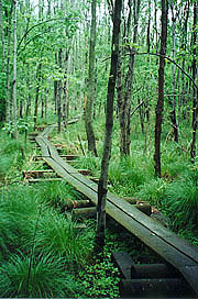
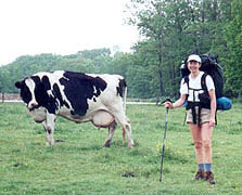
Here the bog bridges begin
in earnest as we cross a pasture hosting the first Jersey's we've
seen in Jersey, and I can't resist a pix of Coleen by one.
The puncheons (bog
bridges) never extend quite to the end of the bog (leaving a small lake at the
foot of the stile), and soon our boots
and socks are soaked not only from the mist, but from tramping
through mud. Canal Road marks the beginning of a
planned trail relocation that we've been anticipating for days. A
magnificent suspension bridge is being built spanning Pochuck Creek,
and our map shows this relocation which promises to avoid two miles
of road walk. There's no indication as to when this relo
will be complete, and we find to our dismay that the blazes follow
the old route. A chipmunk sits atop an adjacent boulder, watching our perplexed looks
as we debate which way to attempt. Though there's a chance
the relo might be open (we'd like to see the project), we
have to go with the white blazes, so we begin the long road walk
around the marsh.
After a little confusion at the closed Maple Grange Rd bridge,
we continue on a road devoid of traffic, walking dead center in the
road, but this soon changes. At the busy County 517 we turn north,
passing the
beginning of a gaggle of thru-hikers. They're the leaders of the northbound
pack; and as such they're totally focused on speed, rarely wanting
to stop and chat. Several pass with just a wave, but we manage a quick
chat with a bearded European sort (Bert "the
Bavarian") who shares a little info on the Unionville hostel for
which we're bound (we'd love a dry bed tonight, even if
it's marginal). Finally the path returns to the meadows, taking our lunch there on our
poncho.
Back to the meadows, hills, puncheons, and
hemlock groves - eventually we begin a gentle climb up Pochuck Mt.
Again, the promised vista is immersed in cloud, and we try to
imagine the joy with which the northbounders often receive their
first view of the Manhattan skyline. At the Pochuck Mt
Shelter we laugh at the register entries - the standard "Here
comes Elderberry!" entry, along with a poison pen diatribe by Warren
assailing the local trail club with anal complaints (other
hikers taking arms against Warren in defense of the trail's
proprietors). Back on the trail, we pass a number of water jugs left
at the mountain's base - some well-appreciated
trail magic for which, alas, we have no need. We return to the
bogs, where an extended walk on the bog bridges proves slippery, and
finally results in me taking a tumble on my pack, leaving me lying
on the puncheon, my pack beneath me with its top in the mud; totally
unable to get up due to the leverage of the packframe beneath me.
Coleen helps me up with a chuckle as we reflect that, had our
positions been reversed; I'd have taken a pix before aiding her up.
No blood, no foul, so we continue, passing a
thru-hiker intent on exchanging intel, and a local lady trying to
keep her two dogs on the puncheons. |
| A walk in the woods?
|
|
|
The puncheons end in a
road circling a large swamp, and on the road we find our old favorite, the Prairie
Home Companion to entertain us. We finally reach the road to Unionville, heading
into town as a light rain begins to fall, but nothing on the road matches the map, and we stop
to ask at a house where we've just seen the owner pull up. Despite
the barking of his dogs, he won't answer the door, and we stand in the rain
reflecting on our error for a few minutes before deciding that we're
at 284, not Lott Rd, leaving us with another mile to go. Coleen's
feet hurt terribly, and I hate to reveal this to her, but
at the other end lies our warm hostel, so off we go for the
final mile.
Finally we reach the real Lott Rd for the final
.4 miles into town. We've no idea how to find the hostel (and
worried about it being open on a Sun evening), but it's a very
small, rust-belt town, and can't be too hard. While still
blocks distant, we hear loud music playing; and sure enough, it's from
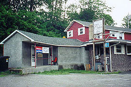
a small tavern to our right. We spy the Back Track Inn, and hobbling
that way, we find it the only place alive in town, a small
crowd of pickups clustered about. On its left face is a Hostel sign,
so we drop our gear and head into the tavern to find out the deal.
The marquis says that "Little Sammy Davis" is playing tonight until
8:00, good for us, as no sleep will occur until his set is over. The
din is deafening, and there's no lack of good cheer, with lots of
urging to join the party, and one drunk very insistent about buying us
a drink. When we finally get to the barmaid, she and the owner
arrive at a $3 charge each for the hostel (normally $5, but the
shower isn't working, and the only lav is in the tavern - open noon
to midnight). |
|
| Beats wading through the swamp
|
|
At the "hostel",
the big shock occurs - it's a large closet, with storage racks
on the wall now intended for our sleeping comfort. There's a small
table at one end, one bare light bulb, no window shade, a couple of
old chairs, and some trash and odd hiker items left by previous
hikers. It's dry however, and we rig a shade and find room to change
clothes, though we really don't have much dry to change into. Coleen
wears her rain pants, myself my shorts, and with our cleanest shirts
and jackets, we head out in search of food. They've rolled up the
sidewalks in town, and we end up back at the revelry at the
Back Track. Asking for a menu, we're told that there's plenty of
food left in the buffet; so without even a cover charge, we're soon
eating steak, pork cutlets, and baked potatoes as Little Sammy Davis
belts through far too many encores. The band is deafening, but
fairly good; and it's a Kodak moment for us (besides which, a couple
of gin/tonics really mellow the mood). We're there about an hour
before retiring to the Gulag, where we set out everything possible
to dry, secure the door as best as possible, and retire lightly
medicated at 10:35.
5/22 Unionville Hostel - Mashipacong Shelter (14.3
miles)
"Wherever your journey takes you, there are new gods
waiting there, with divine patience - and laughter."
Susan M.
Watkins Coleen's awakened at midnight by some commotion
involving a screaming lady and the adjacent fire station, but I
don't even remember it. My first recollection is a couple of girls
waiting for the school bus at 07:00, but I fall back
asleep for another hour. Looking around our corner of a
room, the phrase "Muddy, but unbowed" comes to mind as we pack for
another rainy day. Coleen has numerous blisters on her toes, so I
suggest wrapping small rolls of duct tape around each one -
surprisingly effective. |
| Yes, it needs milking
|
|
| The hostel's on the left - no,
really |
By 09:22 we're back up to the trail,
with a quick stop at the edge of the forest to use the facilities
(the tavern being closed till noon). It's a bit more woodsy as we
begin, and we pass more small groups of thru-hikers headed for Katahdin.
The sky is lighter, with occasional glimpses of the solar corona
visible for mere seconds through the gray. The trail follows the
NY/NJ border northwest, crossing Vernie Swamp with another extended
puncheon walk, after which the sky darkens and the wind
rises. This marks the end of the improving weather, and the
beginning of the climb towards High Point. It's steady but
well-graded, and we keep a fast pace, hoping to make the
Visitors Center for a late lunch. Coleen is already getting ticked
over the fast pace, but I find a good radio station playing Russian
Easter Overture, and this calms us both as we climb. The terrain
becomes more alpine, with hemlock and cedar groves
replacing the marshes, and as we pass the trail to the High Point
shelter, a beautiful mountain stream surges through a small canyon
below.
The trail winds its way uphill, and soon
we hear the voices of a small group ahead - a group of boys,
scouting age, all black save one, and loaded with gear as for an
extended stay. We catch them just after the side trail to the High
Point monument, (obscured in the low cloud) before starting
a steep descent towards the Visitor's
Center, with Coleen particularly irritated at my fast
downhill pace. Luckily, it's a short walk from here to the center,
arriving at 2:00 feeling cold and wet, and finding the center
virtually deserted.
High Point is as the name implies, the
highest point in the state of NJ at a mere 1803', and would be a
beautiful park in good weather. In the office several personnel are
working, but where we park behind a huge fireplace we're
unnoticed; and here we have our lunch. Coleen's hurting a bit and
totally demoralized, and it's obvious a long break is needed
aimed at inspiring her. I'd like to position our stop
tonight to allow us to finish in 2 days, and she'd just as soon quit
right now. After lunch, we linger as I get info from the rangers
(bear problems at Rutherford campsite - the
result of a camper abandoning his tent, food and all). Coleen's still
cold, so I stealthily set up our stove on the hearth for coffee.
Coleen's far from being ready to commit to a 2-dayer, but willing to
consider it, and we shove off again into the mist after a long 1:40
break.
The extended break has done Coleen a world of good,
allowing me to duct tape my blisters as well, so we start out,
evaluating our options for the coming nights. We'll
definitely bypass Rutherford shelter, as it's only 1:20 ahead, but
we'll probably stop at Mashipacong (accent on the "ship") shelter
tonight, tenting out the following night. As we walk we scare
up a small fawn, and at 5:15 we pass the trail to Rutherford shelter, which
heads straight down the steep incline, easily convincing us to
forge on. Soon the rain begins, gently at first, but
gradually increasing to
where a shelter sounds excellent for the night. |
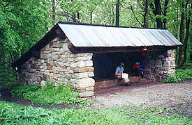
After the Deckertown pump it's a
short walk up to the shelter - a stone structure with a corrugated
roof - most importantly, unoccupied. The register has
no mention of the dreaded shelter
mice (does mention the over-full privy though), so we spread out,
allowing room for others (when it's raining, "the shelter's not full
till the last hiker's in"). I erect a clothes line for our wet
clothes, and start the water boiling, leaving a quiet moment to sit
and watch the pouring rain. It's actually quite nice,
in our relative comfort, and as darkness falls we have our
dinner and cocoa. The bear box has a broken lid, so I fly our food,
and soon the clouds obscure our mountain home, the
visibility dropping to nothing as the rain continues. Our lights
project an eerie conical beam into the fog,
giving one the feeling of wielding the ultimate Jedi light
sabre. It's oddly cozy here, shrouded by fog, and
yet protected as the rain gently drums on our roof. Bed
10:25.
5/23 Mashipacong Shelter - Hemlock Falls campsite
(17.4 miles)
"'Twas in another lifetime, one of toil and
blood
When blackness was a virtue and the road was full of
mud
I came in from the wilderness, a creature void of
form.
"Come in," she said, "I'll give you -- shelter from the
storm."
Bob Dylan - "Shelter From the Storm" We're up at 06:00 with first light,
after a restful night for me, and somewhat less for Coleen.
With the spacious shelter to
ourselves, morning prep is easy, and Coleen opts for hot oatmeal
rather than oatmeal cookies. Our gear is no drier than
before, so it's another day of climbing wet rocks in wet socks.
We start with an easy forest walk, climbing
through a birch grove for variety (the birch are numerous, but most
are downed or dying). The fog thickens as we climb into the cloud
layer, and a couple of local hikers give us some info about what's
ahead, along with a weather report, suitably gloomy. Passing
the Sunrise Mt parking area, a small bus awaits another
group, and again we find jugs of water left by trail angels.
A little further along is the Sunrise shelter - a huge open
building, which would be great for lunch if only there were tables.
|
|
| Putting the ship in
Mashipacong |
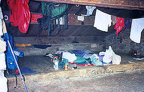
|
| Trail housekeeping at its finest
|
|
With town food ahead at Culvers Gap,
we make a lively pace, descending to a nice forest walk in a hemlock grove where
we soon spy the
hiker-popular Worthington Bakery. It's now closed on
weekdays, sending us to Gyp's Tavern, where we find a meager menu of the
usual burgers and pub chow. It's overpriced and fat-encased, but
heavenly for our purposes, and we wolf it down, entertained by
our neighbor at the bar. He shares
some bear stories, telling us of one treed by the dog next
door a few days ago (promptly falling asleep until the dog tired of
the game).
We head out revived, with the usual climb out
of the gap, moderately steep, but a mere 350'. Back on the ridge we
see several lakes in the improving weather, along with our first
efts, their tiny orange bodies slowly crossing the trail in utter
ignorance of their potential destruction under our feet. We
pass the Brinks Rd shelter, the last shelter we'll pass, but by now
Coleen is sold on the idea of finishing tomorrow (well, at least
amenable). A few minutes later we find a good spot for our pm break
- lengthened for first aid on our feet. I've a long, slender,
painful blister formed on a wrinkle (from wearing wet socks) on my
LH sole, and there's no good remedy. Passing the summit of
Rattlesnake Mt, the rain begins as last night, and the pack covers
come on. |
| A little "froggy" up at Sunrise
shelter |
We descend through a beautiful hemlock
grove along a stream - an excellent camping spot, but we need a few
more miles if we're to finish tomorrow. The trail turns uphill
and rocky; and the rain intensifies, making the rocks slippery and
slowing us considerably. Luckily, the trail joins a gravel road,
a real boon to our spirits and speed. We hear voices ahead, finding
a large tarp with several campers, who tell us we're about to
pass a no-camping sign ahead. We'd known of this
restriction, but it seems merely a bureaucratic morass, so we're
both content stealth camping. We start looking for sites, and as
darkness falls, our standards fall with it, finding a good clearing
at 7:45. We quickly get the tent up, moving essentials in to begin
dinner under cover. All goes well for our 1st use of the new Coleman tent �
a snap to set up compared to our previous one. We're
comfortable and dry, and after dinner comes dessert and hot
chocolate (with our excess food we can eat like kings). A lull
in the rain allows me to hang the bear bag, finding a pea-soup fog
out, and stymied a little finding no branches high enough. It'll be
mainly a raccoon bag tonight, and if any bear of size wants our
food, it's his, hanging about 7' high. We're in bed at 10:30,
sleeping comfortably until awakened by a violent thunderstorm at
03:00. With the lightning comes the rolling thunder, echoing
forlornly through the mountains as we drift back to
sleep.
5/24 Hemlock Falls campsite - DWG (18.7
miles)
"To endure is greater than to dare; to tire out
hostile fortune; to be daunted by no difficulty; to keep heart when
all have lost it -- who can say this is not greatness?"
William
Makepeace Thackeray We wake at 06:00, finding the fog
thinning quickly, the birds singing, and the morning taking
on considerable light. It's plenty warm, but everything's wet, and
we make quick work of breakfast and packing.
I've put more duct tape on my feet, though
there's no way to adequately cushion the long, slender blister on my
sole. Its shape prevents first aid, and the pain is continual; but
being homeward bound, it's bearable. The trail descends to
Buttermilk Falls, a steep but short climb down which would have
been tough in last night's darkness. Off our right is the
Harding Lake Rock Shelter, an ancient home to Indian hunters circa
3000 BC, but with all the rocks to dodge it remains unseen.
|
Passing Blue Mt. Lakes Rd
we find a pump said to have potable water, so we tank up after
purging it to reduce the metallic taste. The trail follows a dirt
road as it climbs, the clouds begin to thin, and suddenly
they break up completely, with the glorious sun
emerging - what a sight after 70 miles of gray! Soon the
rocks and woods reassert themselves, as we descend to circumnavigate
a beaver pond before climbing back to the ridgeline. We stop at a
beautiful ridge (where the Rattlesnake Swamp trail diverges) for pix
just before lunch.
The quality of our pump water is
seriously lacking, so at Camp Road, we stop at
the beautiful cascading stream to
put the filter to work (though the mosquitoes swarm us as we
do). At least we've clear, cool water for the climb back to the
ridge, with the day turning hot and steamy. We then enter
Worthington State Forest, climbing to a stone cairn atop the ridge
for our last break. The radio spells the doom and gloom
of building thunderstorms, and indeed, as we sit the sky
quickly darkens to the west. It's good to have relief from the sun,
but we know this portends a real downpour, so we hurry back on
course, descending into the woods. |
|
| Finally - sunshine and a view
|
Suddenly Sunfish Pond emerges -
the southernmost glacial lake on the AT. The trail turns rocky,
and it seems the goal of its creators is to stay on
the water's edge, whatever the cost. It's a horrid scramble over
boulders and glacial debris, and we soon find a small field of stone
cairns apparently erected as a sacrifice to the gods of the difficult
trail doctrine. After depleting my film here, we laugh that now,
with no film, we'll probably encounter an epic hailstorm, dancing
bears, or some other Kodak moment.
The state of the trail
worsens, bypassing a smooth placid meadow above in favor of this
boulder field; and to add insult to injury, it's poorly blazed.
At its far border are signs prohibiting the remotest
thought of camping here, and the sky further darkens. The rain
begins in earnest, preceded again by the majesty of the rolling
thunder - impressive indeed. The wind rises, forcing us to don our
jackets, yet we slug on towards the goal. Finally we
pass the Holly Springs trail - the 1 hour-to-go point, and soon after
the rain stops and the skies clear.
Passing the mile-to-go
point, we hear the roar of a large waterfall, and suddenly we're
treated to a cascade which is beyond a doubt, the most beautiful
scenery I've yet seen on the AT - and me totally without film. The
cascade is not an isolated slice of beauty, but one which
intensifies, showing new facets all the way down Dunnfield Creek.
It's a stunning ending to our day, and we forget all our previous
aches and pains. The water is aquamarine blue, crystal-clear, and
possessed with awe-inspiring force as it thunders down the rock
faces, surrounded by the solemnity of a Pacific NW rain forest. We
will return.
Suddenly the parking lot is in view, and we hate
to leave this Eden, but we both know the exact distance to that red
Eclipse with the dry clothes and the cooler of Diet Coke -
we're unstoppable now. Finding the Visitor's Center locked, we make
a quick shoe and sock change, and load and go. In no time we're
making our typical post-hike hobbled walk into a nearby Burger King
for hi-cal food and monstrous drinks. The drive home clears the
thunderstorms, but not before giving us a beautiful view of the
setting sun, its orb barely visible in golden splendor through the
last of the rain.
The waters had yet one final revenge for us
- on return to our garage, we heard a hissing sound emerging from
the laundry room, and on opening the door we found the line to the
washer had burst, flooding the basement beneath. Just when we were
looking forward to a hot jacuzzi and a dry bed, we'd spend the wee
hours of the morning with a wet-vac cleaning out the basement.
Welcome home?!? |
| |


