The Road Not Taken
¤
Sometimes, the road is less traveled for a reason
Erwin TN - Hampton TN
As summer settles in it seems logical to head north,
but tales of black flies and mosquitoes inspire a different approach
- maybe a southern section, but one of sufficient altitude to
moderate the temperature. We want to catch the famed
rhododendron blooms at their peak, though the one guidebook quote we
really need escapes our notice until we're on the drive down -
"In full bloom, their dense masses and thickets make the
traveler's path one of indescribable beauty ... The probability of
heavy rains characteristic of the region during this season may
offset the advantage of travel to witness the floral display,
however."
6/16 Erwin TN to Deep Gap tentsite (12
miles)
"Two roads diverged in a wood, and I -
I took the one less traveled by,
And that has made all the difference."
Robert Frost Our June adventure begins at Erwin,
on the banks of the lovely Nolichucky River at a hostel owned by
"Uncle Johnny" (our shuttle and AT icon). The
grizzled-looking "LionHeart" (doing a "work for stay" program)
shows us around the magnificent hostel as we wait for Johnny. The
extensive photo album of passing hikers merits a look,
including one well-endowed girl wearing only her pack, with some
clever shading by magic marker. Soon Johnny pulls up, and after
checking in we're afoot, crossing the bridge
northbound at 2:12.
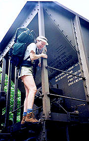
Our first obstacle is a railroad
track with a huge stretching endlessly in both directions.
The guidebook has strict warnings not to cross between cars, but
with no hope of getting around it, the ladders on the cars seem
obvious. Coleen's appalled at my cavalier approach, but once I'm
over, what else can she do but follow? The trail parallels the RR
and river, climbing slightly, and I annoy her with my rendition of "Me &
Bobby McGee" as we head up ("Busted flat in Baton Rouge, waiting for
a train, with a feelin' that's as faded as my jeans ...", etc, etc). The trail winds steadily uphill through a
lush forest with coursing streams; and soon a rainstorm we've been
watching warily spreads to encompass our area. The pack covers go on
but it's too warm for jackets (the forest canopy giving some shelter).
During a rain
break at Curley Maple Gap Shelter we meet Aimless and Sirocco, a
couple girls heading south on a flip-flop (started at Harper's
Ferry, planning to airline from Springer to Katahdin for the last
stretch). They warn us of the difficulty of the Dennis Cove to
19E section, and of the
legendary hiker hatred at 19E (ignited by the terms under which the
Park Service appropriated the trail lands, and magnified by the
culture and alcoholic preferences of the locals - a microcosm of the
cast of 'Deliverance'). Stories include a hikers hit by thrown beer
bottles, a dead cow left in a spring, barbed wire strung across the
trail, etc. - probably exaggerated, yet a worthwhile reminder that we're out of our element.
|
|
| Didn't notice the car's legend until
getting the pix back - Honest. |
|
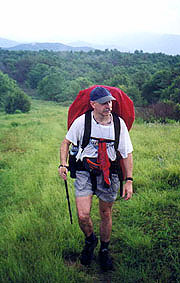
The rain subsides as we hit
the trail - pretty but featureless (we do scare out one doe and a
pair of pheasant) and soon the sun comes out. By 8:06 we climb the
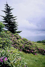
Beauty Spot (love these long summer days), a natural bald summit
with splendid views where we plan to camp. The approaching storm and
lightning discourage our camping directly atop the bald - a
nearby stand of spruce looks more promising, but the guidebook
suggests a good campsite a little
further. We find it badly overgrown, and warned about the locals, it
seems best to seek a site further off the road. A meadow we pass is
promising, but a number of 4WD tracks there make us leery (imagine
your tent mowed down at midnight by drunken high-schoolers). Dark is
falling, but Coleen's still cool, so we continue; passing up another
possible site (hoping to be near water), joining the road at Deep
Gap.
Now we know where we are (further than planned), and
there is a campsite here, but it directly abuts the road, lending security
and noise concerns. After
finding the spring, we tank up and head back to the previous
site - by now it's 9:20 and getting seriously dark, so Coleen starts
dinner as I pitch the tent. A stiff wind blows off the ridge, and
the prevailing slope dictates that I set up the tent crosswind to it
- something I hate to do for rain-worthiness. But, there's no other
good choice, and soon we're set up, savoring dinner by flashlight.
Bed 11:20. |
| Even in rain, the Beauty Spot offers
panoramic views. |
|
6/17 Deep Gap - Clyde Smith Shelter (13.1
miles)
"Forget not that the earth delights to feel
your bare feet and the winds long to play with your hair."
Khalil
Gibran, The ProphetIt rains most of the night, but
thankfully it's stopped now, and we've both slept well. We're up at
07:06, and on the trail by 08:30, our route quickly turning uphill
over Unaka Mt., a beautiful mountain dominated by a spruce and
balsamic fir forest, with rhododendrons and flame azaleas blooming
in the transition zone. We chat with a nice older couple from Oak
Ridge section hiking, but they're far slower, so the chances of
seeing them again are nil. Descending back to the hardwoods, we
reach Low Gap at 10:20, leaving me confounded by our late arrival
here - a mere 1.5 mph pace with stops factored in. As we break,
Coleen wolfs down our gorp, starting a small tiff (I'm anxious to
get going, which she says she'll do after one more handful, taking
that handful, and another, and another). By Cherry Gap
shelter however, we're back on good terms, filtering water, and
re-evaluating tonight's stop (at our leisurely pace, a town night tomorrow may
be impossible).
More ups and downs - up over Little Bald
Knob, down into Iron Mt. Gap (a busy road here), back up the other
side where we catch a late lunch. The pm is largely featureless,
save one rock overhang the guidebook suggests could provide shelter
in an emergency, which hasn't yet occurred. My feet have some hot
spots, inspiring a new strategy - hiking a couple miles in my camp
sandals, affording my feet a welcome break. A number of landmarks
pass unnoticed, and soon we've only a vague premonition of our
progress. As we're studying the map, a hiker and her dog yell to ask
if we know the distance to the shelter, which we don't. Seconds later,
we reach the sign, and Coleen yells back to her a correction.
The sign advertises a .1 mile trip to the shelter (grossly
understated) and minutes later we're there, our friend pulling in
behind.
She's Cindy, a Phys-Ed teacher from Houston with
G-dog, and they pitch a tent nearby in deference to our possible
feelings about dogs. Looking at the shelter, we elect to tent
ourselves, though our priority is water and bathing, down a steep
trail to the spring, with Cindy joining soon. We all settle down to
dinner at the shelter, where I have visions of building a fire; but
just as we finish dinner a building thunderstorm erupts in all its
splendor. There's considerable lightning and thunder (to
G-dog's dismay), but it soon lets up, and after cocoa we all retire to our
tents, in bed by 9:30. |
|
6/18 Clyde Smith to Overmountain shelter (12.4
miles)"Each humid tropic day is stillborn, and does
not breathe, however lustily pregnant the night that gave it
birth."
Beryl Markham- West With The Night At
06:23 our very muggy morning begins, our wet clothing still wet, the night
yielding nearly continuous rain; though an expansive
evergreen overhead gave some shelter. Cindy and G-dog rise just
before we leave, and after farewells, we're off for our tough day,
including the signature climb of Roan Mt. - 2200' up in a mere 2.6 miles.
First however, we must surmount Little Rock Knob, through laurel
thickets, with naught to see save fog and low cloud.
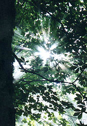
The
scenery abruptly changes from nonexistent to spectacular as we
emerge onto a rock cliff overlooking the valley just as the clouds
break. The effect is breathtaking, breaking from dense wood to this
sheer overlook, the wind gliding sheets of cloud beneath us at
dizzying speed. A patchwork of farms below is momentarily revealed
as the clouds sail by; and we linger, savoring the moment. Even on
return to the forest the scenery does not fail, as the sun's rays
through the dense fog form sharp sunbeams from the peepholes in the
forest canopy. Beauty is here to be found, and the trail continues
well-graded over the knob and down 900' to Hughes Gap, where the
real climb begins. |
| The morning fog lifts
|
Even as I write later, I
see it was a tough climb from the want of notes in my journal. After
a minor summit at Beartown Mt. the climb continues, passing a couple
teens of the Beavis & Butthead variety, each with a golf club in
hand for reasons unknown. Suddenly the climb abates and we reach the
summit, with throngs of tourists ahead on grounds dotted with
flowering rhododendrons and balsamic fir. We find a picnic table
for lunch, making a quick wash of ourselves and our
clothes in the bathroom sinks. The sunshine's a little spotty (and
the breeze cool at our 6200' elevation), but after a Q&A session
for the tourists (most have no idea that the AT goes
through here, or even what the AT is); we start down, packs
festooned with drying clothes.
We hate
leaving, but at least the
fir, spruce, and bright purple rhododendron blossoms continue for some time, as do the
tourists, out en masse despite the Father's Day holiday. Carver's
Gap brings another crowd, climbing like ants up and down Round Bald
ahead. They say it's a festival of sorts, and we see some of the
same folks from atop Roan, many curious about how we got here (I
know it's painfully obvious now, but it was pure magic to them). The
slope is riddled with tourists snapping pix in the occasional
sunshine, though a gathering storm threatens, so we hike quickly.
The crowd disperses as the rain begins, and soon it's just us
left with one other intrepid couple. The pack covers go on, followed
by rain jackets, in feeble hopes of dry T-shirts.
The path
descends to a dense thicket, a miserable trail in the rain - not
enough cover for shelter, but narrowing the path to a thin, deep
trench full of mud and standing water. We're hungry too, finally
finding a tree with modest shelter to break out our gorp for a
stand-up break. We bend over the bag to keep it marginally dry, but
still the M&M's melt over our wet hands, now looking like a
finger-painting exercise gone awry. Finally we come to
the Stan Murray shelter, a good refuge to check our navigation -
we're still at a snail's pace if the mileages are to be believed
(doubtful, given our erratic speeds of late). As we do, a pair of southbound
teens come through (one with an American flag draped over his pack),
having just come from Overmountain shelter to escape the growing
crowd there. As we chat the rain breaks, giving us excuse to stow
our rain gear and head on.
We're driven towards
Overmountain, having heard great things of it from Uncle Johnny and
other hikers, though concerned there won't be room. I make a
concerted effort not to run away from Coleen, and our ETA passes
without a trace - just as we get concerned, the shelter trail
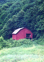
appears, with plaques detailing its history. The trail descends
through a meadow past the spring, where the woods open suddenly
revealing this idyllic setting. To our right is a steeply forested
ridge into which the barn is set, overlooking a long valley
clustered with fir groves. Across the valley, the mountain is topped
by an alpine meadow from which we'll look down on the barn tomorrow.
As we approach, a single pair of legs shows through a large
rectangular opening in the loft - approaching closer, their owner
peeks around the corner, welcoming us to the party. |
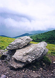
|
| A few moments for photos at Carver
Gap before the deluge breaks forth |
|
| Rhododendron blooms
|
|
It's now obvious that all
concerns about room were unfounded - the structure could easily
lodge a hundred. The lower level has two open platforms under roof
for sleeping, with a picnic table between; while the loft is a
darker but more spacious area. One tent's set up in the loft, along
with several bedrolls (5 folks topside), and on the lower level are
3 bedrolls on one platform. The upper level looks the best chance of
being mouse-free and warm, though the lower offers a stunning view -
the tie-breaker is a loud, self-important hiker upstairs perpetually
lecturing his victims on all things trivial (Coleen deems him the
archetype of Bryson's "Mary Ellen"). We opt for the view and the
peace, dropping our packs downstairs as Coleen heads back to the
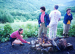
spring for a quick bath. Ray is the leader of the downstairs group,
filling his spare time introducing others to the ways of the wild.
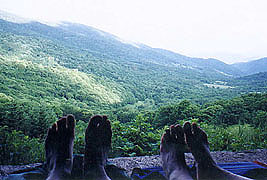
They're a good bunch, and after dinner we take a few pix (my shots
of our toes with the valley behind are a big hit, and others copy
the motif), and with dark approaching we build a fire to toast
marshmallows. As darkness falls we hear the hoot and whet-saw owls,
along with an occasional coyote, turning in at 10:30 as the first
glow of the moon illumines the thin clouds overhead.
6/19 Overmountain to Walnut Mt. Rd tentsite (15.7
miles)
"As the deer pants for water, so my soul
pants for Thee.
Psalm 42:1 |
| Back to our rural heritage at
Overmountain shelter |
It's a little cool
overnight, but not bad, and sleep is impeded more by sounds of
snoring and owls than the cold. There's no hint of mice, though when
"Mary Ellen" above rolls over, he sifts dirt from the loft down on
us. We're up at 6:13, finding it cloudy, but no fog in the valley (a
surprise, as a few wisps formed last night over a stream there).
The downstairs crew depart early, and after a brief stop for water
(behind a couple of girls tenting nearby), we're off,
turning uphill into the alpine meadow above. It's a great view of
the barn, and the trail continues through a series of turnstiles
isolating cattle in the coming fields.
Today's challenges
include Little Hump and Hump Mt., and we're soon climbing Little
Hump, the girls just ahead. In the cool gray weather it's easy
enough, though Hump Mt. proves more challenging. Both are balds -
round hills devoid of trees or shrubs atop, though located too far
south for an actual timberline. Their origin is unknown, with
theories ranging from overgrazing to alien landings,
but they have a beauty all their own. Hump Mt., at 5587' is crowned
in cloud, the fog and cloud sweeping across the path ahead of us as
we climb. It looks as though it will blow through, but as we climb,
I realize that like Denali in Alaska, it makes its own clouds as the
moist air accelerates over the summit. Although the cloud can be
seen moving downwind at great speed, the upwind edge is
seen to be continually forming from clear air to keep the very
summit continually and solidly encased. It's a fascinating spectacle
(it must be seen in motion to appreciate it), and we watch the girls climb into the cloud,
followed by ourselves. |
|
| Roasting marshmallows at the
beautiful Overmountain Shelter |
|
| What a view to fall asleep to!
|
|
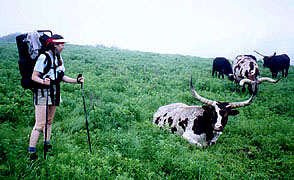
Starting down, we leave
the shroud of fog, though before leaving the bald is yet another
treat. A herd of longhorn cattle occupy a corner of the field we
cross, seeming sufficiently acclimated to hikers for closer
inspection. Coleen's a little wary of the idea (most look like
steers, though some are lying down with calves), but I manage a
quick pix before we descend back into the thickets. We leapfrog the
girls a few times as we each take our breaks (they're destined for
19E), and crossing Doll Flats, a group of young boys (scouts
perhaps, no uniforms) passes us stretched out over almost a mile.
|
| We husbands know this look
|
It's a muggy and featureless descent through steep switchbacks - we
finally pass Apple House shelter, a dark and dank unappealing place,
stopping in just for intel. It's too muggy to peruse the register, but there
is a note about a significant relo (trail relocation) ahead, not shown on our maps.
Moving on to 19E, we find a large coed group of teen campers
starting southbound and a box of food (left as trail magic by Inchworm),
but alas, no nearby cafes for town food, so we continue. After crossing
the contaminated Bear Branch (as are most streams in the area), we
ascend steeply on switchbacks.
It's a tough climb, and we're glad for a
lunch break on the first available log, planning on refilling our water
at a spring 1.8 miles ahead.
Passing a stepstile, the trail crosses a cow pasture, in some places
very sloppy on heavily trodden roads, counting down the minutes
to the spring. It's located at the
base of an old house foundation, and on seeing it, our worst
fears are realized - the water surrounding it is full of cow dung!
It's not even running, and the pool below is badly
fouled by the cattle. It's a significant taste of despair and anger
we now share, as the streams we're to cross are all contaminated,
and our water depleted.
Water is the lifeblood of the trail,
and while the onset of dehydration may be slow and insidious to a
man marooned in a raft, it is swift and debilitating to one carrying
a pack up and down mountains. Still there's little else to do but
continue, knowing that we may have to get water from an uncertain
source.
We forge on, gladly leaving the cattle behind and
climbing into a meadow cooled by a light rain (though
far too slight for collection). We pass a cemetery, searching
in vain for a spigot that might be used for grounds maintenance. As
we're paused though, the light comes on - a road crossing in a mile
is marked by a turn "across from the High Point Baptist Church" - the
church must have a water spigot. Even though the guidebook
makes no mention of it, I'm sure we can beg some water there,
occupied or not. Our hope restored, we surge ahead, the promised
road arriving, with the church a short walk past - vacant, with a
water spigot on the rear of the activities trailer adjacent. What a
relief!! - replenished (bottles and bodies) and eternally grateful
to our Baptist brethren, we proceed to the first of 5 crossings of
the contaminated Jones Creek (doesn't look so bad, now that we have
clean water in our bottles).
The trail is easy enough until
Sugar Hollow, a steep descent into the exceedingly dark and muggy
hollow, reminiscent of the jungles of Borneo. It's painfully obvious that if one
camped a mere 50' off the trail (if you could manage to hack
your way there), you could die in your tent and never be found. It's
a tough descent (glad we're not southbound), and a relief to cross
the bridge over Sugar Branch for a progress check and a moment to
assess our options. Although there's a campsite down here with
water adjacent (Coleen would love to bathe in a stream tonight),
it's so dark and oppressive that we can't wait to get out of the
hollow, even if it means another hour or so's walk to an uncertain
site.
Thus begins our climb back
out - what a joyous relief to climb back into the
light (even an occasional breeze) on Big Pine Mt, a long
climb, but gentler than the other side.
We pass an old moonshine still just prior to Slide Hollow,
a poignant reminder of the local preferences.
Finally at 7:00 we
find a possible campsite - the junction of a couple of old roads
previously used as such. As we're setting up camp, another hiker
comes up from behind - he's gotten a late
start, bound for the Moreland Gap shelter, and wonders about the
mileage (it's 6-7 miles, putting him there well after dark). After
encouraging us to stay out till the 21st for Nude Hiker Day (a
summer solstice tradition)
he's back on the road. Soon we have the tent, dinner, and a fire
(surprisingly easy for wet wood) going, and we sit on a Thermarest
at the base of a tree as we dine. It's cleared off nicely, and as
night falls we toast the last of the marshmallows as we anticipate
our return to civilization. Bed 10:15.
6/20 Walnut Mt. Road to Dennis Cove (12.4
miles)
"There is a boundary to men's passions when
they act from feelings; but none when they are under the influence
of imagination."
Edmund BurkeSave a brief slice of
moonlight peeking in our tent, it's an uneventful night, and we wake
to find it surprisingly clear. Our gear is untouched, the tent
fairly dry, and we hit the trail at 07:56 with
spirits high. We make good time, crossing several small streams - in
one the water cascading over a series of large boulders seems a good spot
for our am break; complete with a very soothing foot wash in
the frigid water. There are more ups & downs,
and by noon, we hit the long-sought
Moreland shelter, with our priority being fresh water.
Down a
steep but short trail, it's wonderfully cool and clear, and we
filter two full liters before returning to the shelter for lunch. We
get engrossed with the register - replete with the usual admonitions
to observe Nude Hiker Day, stories from Turbo Turtle about his lost
beeping watch, and exploding honey in his backpack. There are a
thousand more stories as these, but we've miles to go, so it's back
to the trail. We start by climbing White Rock Mt,
(the day's high point), followed by
a steep downhill to a short
meadow where we cross a mere 50 yards of open sunlight - nothing
really, but a powerful demonstration of how lucky we are to be
hiking in shade.
The trail then climbs
steeply to a fire tower on an old jeep trail, back in the sun for
far too long. It's a grueling, endless climb, but after
passing the tower, we accelerate downhill like a stone. Our water is soon
depleted, but we're within a couple hours of the car, and are thus
unstoppable. We pass the side trail to Coons Den Falls (yeah, like we're
going to stop), and continue the long descent at maximum warp. Soon
the signs of civilization can be seen - barns, green ponds, fences
and traffic sounds. By 4:35 we begin the .4 mile roadwalk down Dennis Cove Rd
to our car - hot out in the sun, but on level
ground, following a nice river with beautiful boulders and swimming
holes as we approach our destination, Laurel Creek Lodge.
Dennis & Mary (proprietors) couldn't be nicer, and they
anticipate our every need, offering showers and
refreshment (after confirming our identity - until now we were the
phantom "red car people"). We each devour a Diet Coke and head
for the showers, putting on town clothes and feeling whole
again. We settle up with Mary before heading out, the skies
opening to a thundering deluge seconds after we depart. Timing is
everything.
| |


