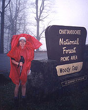
The Game is Joined
¤
A journey of 2,000 miles beginning with a single step
Mt Springer (GA) - Dick's Creek Gap GA
|
11/24 Springer Mountain to Hawk Mountain Shelter
(7.6 miles) "Twenty years from now you will be more
disappointed by the things you didn't do than the ones you did. So
throw off the bowlines, sail away from the safe harbor. Catch the
trade winds in your sails. Explore. Dream."
Mark
Twain
From our comfortable hotel room at
Hiawassee, we're up and ready, heading downstairs for breakfast, where Mac shows at 07:00.
A short elderly man who may be reincarnation of Lord Baden-Powell himself, he sports a BSA jacket
with compass, whistle, and thermometer on lanyards around his
neck. A self-proclaimed "trail angel", he shares a book of pictures
and journal entries of his recipients - a rather
substantial following. Our drive to the trailhead takes increasingly
small and nondescript roads, but soon we're on the final single-lane
dirt road to the parking lot just below the summit. The road climbs
into the clouds, making it a foggy trip, but this somehow seems
fitting for our launch on this perennially wet
trail.
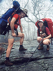
Mac joins us for the hike up Springer Mt, immersed in cloud, but nothing can contain
our excitement, and suddenly we
break out of the forest at the summit, feeling a portion of the awe Moses must have felt on Sinai.
For the thousands who preceded us and those who will follow, this is hallowed ground -
this peak from which they would commit the next six months of their
lives (in our case, six months spanning five year's time). We bask
in the exhilaration that our dream is finally alive before the mechanics
of taking the requisite pictures. Coleen records our launch in the
register, and before heading back down I perform the final ritual
normally associated with this event - the selection of two small
rocks from the mountain. A tradition among hikers, one of these
rocks will remain atop Katahdin at our journey's end, and the other
to remain with us in memory of our 2,167 mile
pilgrimage.
After the appropriate sacrifices, we return to
the parking lot, bidding our final goodbyes to Mac, and without
fanfare, start down the trail. Today is the 15th anniversary of our
marriage, and though we didn't plan the date with this in mind, what
a perfectly appropriate time to open this new chapter in our lives.
We've come full circle, again committing
ourselves to an extended journey that will require our all; whose
destination lies dimly in the distant future.
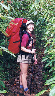
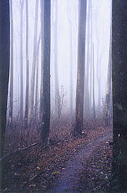
The scenery is
immediately impressive in spite of the drizzle and fog - numerous
holly bushes and pine glades, and we descend into the solid "green
tunnel" of rhododendrons we've heard so much about. It's an easy
downhill, and still giddy with excitement we come quickly onto the
roar of Stover Creek. The trail follows the creek through a stand of
virgin hemlock, and this wonderfully green and aromatic stretch
seems the abode of gnomes or hobbits. We plan lunch at Stover Creek
shelter, but it escapes our notice, and we continue in this forest
wonderland to Three Forks, where three streams converge at a logging
road - an excellent lunch spot. |
|
| The shrine in the clouds
|
|
| Entering the "Green Tunnel"
|
|
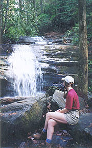
After lunch we climb to
Long Creek Falls, a waterfall on a side trail well worth the
diversion, with the sun even peeking out as we linger. After
climbing Hawk Mt., we set up for the night at the shelter there, with
Coleen searching for water as I satisfy my first need -
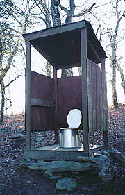
the privy. Privies in GA are generally of the 3-sided open sort
(much like an open bathroom stall cut off at about the 4' level,
with a roof above), and this is no exception, with an airy view down
the mountain from the throne. I then begin building a fire, the
easterly wind off the ridge and wet wood forcing me to use half a
pack of matches before finally using a kleenex for tinder. I school
Coleen in the art and science of using my ancient stove (more the
former than the latter), getting water boiling with the shelter
still intact and undamaged. We try cooking the Lipton dinners in the
bag, which works well for the stroganoff, but not so well for the
beans and rice, which emerge a bit crunchy. Thus sated, we spend the
evening sitting around the fire recalling anniversaries past,
knowing that this would be one of the most memorable. I write
in my journal by candlelight and listen to a little radio as Coleen
reflects by the fire, and soon it's time to bed down. The sky
finally clears, and the stars come out, but bedtime comes before
moonrise in the east. We settle in early, although sleep comes with
difficulty - Coleen hears sounds that might be mice, and after
midnight the deluge begins. |
| Taking a quick break at Long Creek
Falls |
|
11/25 (Thanksgiving Day) Hawk Mt. - Woody Gap
campsite. (13.1 miles) )
"He sendeth His rain on the just and unjust alike."
Matthew 5:45 Our relatives begin their Thanksgiving with
turkey, parades, football games, and family, but ours dawns to a
torrential rain, so hard that we need flashlights to pack.
After coffee and breakfast we break camp quickly,
getting into our rain gear and hitting the trail at 07:55. It takes
motivation to climb out of the dry shelter, but once we start it
isn't so bad, and soon we've worked up some warmth in spite of our
initial descent. The steady stream of water down the trees kicks up
a foam that girdles each one's base, a phenomenon we've not seen
before. It's an easy section of mild ups and downs, with even
Sassafras Mt. (a climb we'd heard to be tough) somehow escaping our
notice. |
|
Each time the rain would
lighten and I'd think about pulling out our guide book, the deluge
immediately reasserted itself. Hiking along the ridge line
is a strange confined cocoon of a world, with woods visible
about 50 yards ahead and behind, and the ridge dropping off into a
sea of white a few yards either side of us. Passing Justus Creek, we
find a convenient log for lunch, and a lull in the rain entices us
for the quick 14 minute stop. As the rain intensifies, we tire of it quickly, planning our afternoon break at
Gooch Gap shelter for a short respite. Here we find
the trail makers have played a cruel joke on us, taking the
trail off to the unseen shelter, finding out 10 min later that it's
a long way off across a couple hills, vs the perfect spot where the
trails diverged.
It's good to get out of the rain even for a
few minutes, though it's a shabby shelter -
a small wooden box, dirty, and surrounded by drowned mice.
We take a long break here, catching up on the register and our
navigation before finally resuming the trail. We pass a father and 3
sons who intend to camp there for the night, trading info with them
before we continue. This section is used as a training grounds for
Army Rangers, with frequent small-arms and mortar fire, and
occasional encounters with the troops; but there's little chance of
seeing them today, in the rain on Thanksgiving Day. Slabbing the
south face of Ramrock Mt the south wind blows so hard as to make
my poncho almost an afterthought, streaming away from my body like a kite's tail.
After Ramrock we descend towards Woody Gap, whose
steep canyon to our right disappearing quickly into the fog.
We pass a beautiful waterfall and contemplate filling our water,
although there's a spring shown at Woody Gap, so we continue
without. |
| There is beauty even in the rain, but
enough is enough. |
| We come on the gap
suddenly, with some parked cars, a restroom and a bulletin board.
Coleen's been praying intensely for some form of trail magic here, but to no
avail. Our options are few (darkness is falling), and we plan
to fill our water at the spring, then hike on in to the
Lunsford camping area, advertised as a mere .7 mile up the trail.
While a good idea on paper, it proves a waste of 20 precious minutes
of daylight, as the spring (when we finally find it), proves to be
the only dry thing we've seen today. We decide we can make it on
what we have (plus catching some rain), so we head uphill with all
possible speed in hopes of making the campgrounds by dark. Soon the
watch shows we should be there, but there's no sign of a campground,
and it's getting dark fast. Big Cedar Mt lies ahead, confirming we're past Lunsford Gap, so we turn
about and return to a relatively flat area we'd just
passed.
Now the die is cast - Coleen's teary-eyed,
it's dark as the inside of a cow, the deluge is
worsening, we're both soaked and shivering, and there's no hope of
improvement on any of these scores. I announce that we'll pitch the
tent here, although in the dark we fail to
realize they're in the midst of a blackberry thicket, its thorns
turning our bare legs to pulp as our blood mingles with the
rain. With shivering hands we assemble the tent, and
abandoning all hope of keeping
the inside dry, throw our dripping packs inside to sort out what
we'd need. |
|
| Still with high hopes for a dry
night's sleep - that'll change soon. |
| Finally we can relax, and we sort
through our gear, keeping the essentials for the night, and stowing
the food back into the packs to weather the storm outside (I decide
not to fly the bear bag - if Yogi wants our food in this rain, he
deserves it). With cups and pot out to catch water, we start
cooking in the tent - a definite safety taboo, but our only chance of hot
food. We gingerly start the stove, and soon have hot food and drink
- our lives seem worth living again. We turn in at 8:30, sleeping in short
intervals between the noisier outbreaks of the rain, along with
periodic thunder and lightning (glad we aren't up on Big Cedar). In
the breaks I open the tent flap and sop up the floor, occasionally
seeing the lights of Suches in the valley.
11/26 Lunsford Gap campsite to Neel's Gap (10 miles)
)
"A sky as pure as water bathed the stars and brought
them out."
Antoine de Saint-Exup�ry We awake to the
blessed sound of silence, finding considerable light outside,
although my watch shows it's only 04:00. We sleep until another lull
in the rain at 0630, finding it spotty enough to consider going
outside. My boots are soaked and heavy, but our packs and food
survived the night, and there's enough rainwater in our pot for
coffee as we begin the dreary process of breaking camp in the rain.
Our hands are chilled and our fingers useless, and we wait a while
for a lull in the rain, finally giving up and packing
outside, our gear getting heavier by the minute.
By
08:30 we're afoot, and almost immediately the rain
stopps as we head back up Big Cedar Mt. (to this day, we still
don't know the whereabouts of the "campsite" at Lunsford Gap). At
the summit are several good campsites, although last night's
lightning and wind would have made these rather exciting. Our descent
enters the forest fire area we'd heard so much about, with the area
to the right of the trail burned, and the trail itself forming the
exact boundary where the fire-fighters had made their stand. As
we stop for a picture, "Magic Merc" passes southbound - on
asking if he's thru-hiking, he replied, "In a day and a half, I'll
be through hiking", a joke he's obviously rehearsed a few times.
Just talking to someone so near the completion of his trek is
encouraging, along with the first sight of blue skies passing along
side of Mt Davis.
My pack cover comes off in optimism,
though my jacket stays until we climb Blood Mt in a rising wind. The
climb of Blood (highest point on the trail in GA) is steady,
and surprisingly well graded, with long switchbacks; and
nearing the top we enter the rocks and laurel groves
(considerable fire damage up here). The summit arrives suddenly,
surprisingly crowded by weekenders and a couple of
long-distance hikers cooking lunch. The mountain's namesake
may refer to an ancient battle between the Cherokees and
Creek where the mountain "ran red in blood", although the red lichen
that cover its slopes appears a more plausible explanation. The
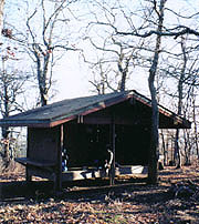
shelter lies immediately ahead, an old stone decrepit building with
the smell of a resident skunk strong in the air. After some pix
and conversation, we head back down towards Neel's Gap and the
promise of a cabin at Goose Creek (which Coleen's been anticipating
for 3 days - even before the rain). |
|
It takes several
frustrating minutes to find the trail, but soon we're
scrambling down multiple rock faces, many with beautiful
overlooks. It's a tough scramble much of the way, with hordes of
day-hikers - finally we spot the road below, and with it the Walasi-Yi
hiker's center - our return to civilization (and the only place on the entire AT where the trail
physically goes through a building). It's a wonderful sight both for morale and
aesthetics, although a blustery wind roars through here. It's a crowded place, and once inside
I find Dorothy Hansen, revered as the operator of the establishment
as well as a former thru-hiker and fount of information. She puts us
in contact with Goose Creek cabins, where I'm told that all the
cabins are sold out, but that the day manager will rent us the
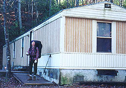
mobile home. |
| Big change from a small tent
|
| This is a good omen, as I've heard the
mobile home is as good as or better than the cabins, and the manager
gives us a good price, picking us up in a few minutes. The cabins
are pretty basic, with a minuscule trailer at the far end, but then
he pulls up a steep grade and drops us at an immense double-wide
trailer that could house some small African nations. It's not much
to look at on the outside, but within we have power, heat, a
king-sized bed (plus several others), cable tv, a washer and dryer,
and all the other comforts of home. The Waldorf Astoria could not
suit us any better.
We dry our gear and go to work on laundry
immediately. Some other hikers call, but never show up to share the
trailer, and we revel in our baths, after which we cook our meals in
the lap of luxury. After dinner, I make the long trek down to the
office to register, finding it a beautiful starry night out, but
frigid in the inky blackness. Back at the cabin, we finish off the
evening with the movie, "Return to Paradise" (sounds apt, doesn't
it?), getting to bed at 10:30 - warm, dry, and almost giddy in our
luxury.
11/27 Neel's Gap to Poplar Stamp campsite (12.5
miles) )
"I've topped the windswept heights with easy grace -
where never lark nor even eagle flew"
High Flight - John Gillespie McGee
Jr We awake in perfect bliss as the first rays of
daylight peek through, packing our clean
laundry and dry tent as we make oatmeal and cream of wheat for
breakfast. TV here is such a luxury, and as we watch the
news from DC, we find the rain we hiked in yesterday has closed the
capitol beltway for flooding (something we can't recall before). At the
office, the shuttle driver for two slack-packing
southbounders staying here tonight offers a ride to Walasi-Yi, a hive of activity
in spite of the blustery day.
After a chat with Dorothy
we hit the trail, finding it crowded with the weekenders, though
they taper off as we climb out of the center. We pass our driver's
hikers immediately (Southender and Logroller), and chat
with them only a minute, as they're anxious to keep going (they're
older, but making good progress slackpacking). The ridge crest has
beautiful overviews, but also a cold wind from the north. We're
amazingly revitalized by a good night's rest and fully hydrated, both
luxuries we haven't recently enjoyed. Even the uphills don't slow us
down, and we make great progress, stopping to chat often with
the weekenders. After lunch we find a large group of them on Cowrock
Mt., and as I snap a few pix, Coleen answers the typical questions ("2167 miles" - "No, we don't
carry a gun" - "30 pounds" - "We dig a little hole").
|
| More steep ups and downs -
down into Tesnatee Gap, up over Wildcat Mt., down to Hogpen Gap
(all easy in our invigorated state), although here
I make a frightening discovery. I've had some pain in the ball of my
right foot, and now I find all boot tread has vanished in this area,
the remaining sole worn perilously thin. With 2 1/2 days to walk, I
contemplate wilderness repairs, such as duct-taping a
thin slice of tree bark to it, or dissecting the bill of my cap to
get a thin slab of plastic for this purpose. For now, I modify my
stride to put more weight on the heel, using my pole to unload that
side as well, and soon I've developed a workable (if
awkward-looking) pace.
From Hogpen Gap the trail is long,
level, and unremarkable, so we push up the pace, getting out our
radios for diversion. There's an excellent classical station,
though it seems odd sweating uphill singing Christmas
carols. We pass Low Gap shelter, but it's too early to stop, and
some smoke coming up from the shelter shows it's occupied anyway. We
pass an excellent campsite at Poplar Stamp Gap, but a good one we've
heard of is allegedly a mile past, so we hoof on. With dark nearing,
and no other sites appearing (we're slabbing a steep slope),
we're losing faith in our intel. Just as we get worried, the
promised campsite appears at the very top of the ridge, though the
wind here roars relentlessly. It appears to be the only one we'll
see for a while, so we settle in, Coleen fetching water as I erect
the tent.
Raising the tent single-handedly in this gale
is an exercise in frustration, but I succeed using our gear as
ballast. We're treated to a gorgeous sunset, though in the cold
wind, we don't linger outside for long. My
fire's of little value, as the wind mitigates any
possible warmth from it, so we spend much of the evening
watching its glow through the tent fabric. With
no good branches around to fly our bear bag, I throw caution to the
wind, hanging the packs in the trees close by (if Yogi comes, he'll
only get a single pack, and we've enough food in each to get us
out). Coleen's asleep soon after, though between the wind, the cold, and
the bright moonlight keep me up another couple hours
11/28 Poplar Stamp campsite to Tray Mtn Shelter (13
miles) )
"A man is a very small thing, and the night is very
large and full of wonders."
Lord Dunsany, The Laughter of the
Gods The wind still thunders
across our ridge at dawn, but we're greeted with a beautiful sunrise, and it's
surprisingly comfortable outside. Getting the food,
I find Coleen's pack lightly ransacked, with shards of her food bag
cord on the ground beneath, but the contents mostly undamaged - as
if the perpetrator was frightened away. |
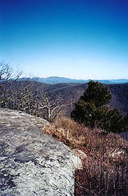
|
| Overlooks here are frequent and
beautiful |
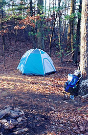
|
| Our mountain campsite, where the
critters made their first intrusion into our food.
|
We're out at 08:38, finding it easy but boring, and well-sheltered
from the wind as we leave the ridge. The uphills are tiring, with
little of interest, although we pass the headwaters of the
Chatahoochee River, made famous in the movie Deliverance. Our am
break renews our strength before crossing a number of tiring rock
slides, and rounding Rocky Knob a lush green area of laurel
and rhododendron provides a delightful change from the browns that have
been our constant companion the last few days. After lunch at Blue Mt Shelter we climb over the
mountain and down into Unicoi Gap, which is crowded with
weekenders.
As we descend, I see an SUV full of
returning campers on the other side, and recognize a chance to
"Yogi" some cold drinks. Their cooler is wide open, and I begin by
asking if they've been near Tray Mtn, and if the spring there was
running (a legit question). My mark tells us in detail of a spring
next to the old cheese factory, although he continued to guzzle his
Kiren and his family their soft drinks without the offer of any. I
wasn't desperate enough to ask, and we didn't quite look pitiful
enough for him to take the hint; although I made a mental note to
assign Coleen any "yogi'ing" in the future, especially when we're
after the male of the species. We took a few sips of our tepid
water and began the dreaded climb up Rocky Mt.
It was steep and steady, but broken up by a stop to chat
with a day hiker and fellow pilot; and by our pm break
near the summit, followed by the descent to Indian Gap.
From here we climb again,
not so steeply as the last, and according to
our map, our last one for the day. The laurels,
rhododendrons, and galax provide some relief, and soon we reach the
old cheese factory site, although save the sign, there's no
evidence of the factory whatsoever. We take our water filter and
hobble over to the spring for its first use in the wild - an
attempt at home produced such iodine-flavored water that we've been
dreading this, but now there's no choice (though the spring
is clean and cold, and it's tempting to take water as is).
Surprisingly, the water emerges very tasty - we drink as fast as
it's filtered, finally filling our bottles before resuming the
climb, refreshed and uplifted by our filter's performance. Climbing
Tray Mt the views are great, but the climb lasts forever,
twisting through laurel thickets that make it impossible to assess
our progress. Finally the trail breaks out at the summit, with
beautiful vistas in every direction before heading down to the
shelter.
We arrive at the beginning of another gorgeous
sunset, and Coleen heads to the spring to clean up as I build a
fire. The sky darkens to a beautiful cobalt blue as the lights of
Helen appear below, and as we're cooking dinner,. another hiker
comes down the trail. It's Trey, a section hiker like us, having
begun with a few others who dropped out with hypothermia and an
aching leg, leaving him alone. He's been about an hour behind us the
last couple days, having been the smoke source we saw last night
after Low Gap. As he made dinner last night, he heard a crashing
nearby, and saw one bear descending a tree in traditional butt-first
fashion, joining its mate at the bottom where they both hightailed
it away from him. As he starts to cook, his overprimed stove erupts
into an inferno that makes my show at Rod Hollow look amateur,
although it's quickly extinguished. His wife is picking him up
tomorrow, which will prove an excellent ride for us, and we all
quickly hit it off as friends. We're all ready to bed down, and
everyone else is asleep by 8:00 as I work by flashlight on my
journal.
I turn out the light a few minutes later, but
immediately hear mice scurrying about the shelter. They stop as I
shine a light around, but continue immediately as I douse the light.
Coleen can't possibly sleep with this going on, and the sounds
approach closer, ending with one of the critters staring at me
brazenly face-to-face from an open pocket of my pack. By now we're
all up, and it's an easy decision to move out of the shelter,
deciding that a campsite just 50 yards away should suffice. It's
pretty easy to set up the tent in the dark (without the rain or
briers), and soon we're set, hanging our packs in the shelter. We
settle back in on the ridge, overlooking the city lights of Helen
about 9:30. |
|
11/29 Tray Mountain Shelter to Dick's Creek Gap
(10.6 miles)
"We have this consolation with us,
that the harder the conflict, the more glorious the triumph. What we
obtain too cheap, we esteem too lightly; 'tis dearness only that
gives everything its value. Heaven knows how to put a proper price
upon its goods."
Thomas Paine, The American
CrisesWe sleep well after
relocation to the tent, waking to a beautiful orange glow over the
valley below, the lights of Helen still visible until the sun
peeks over the horizon. It's cold, but the wind is minimal, and soon
we're into the morning routine at the shelter, where the mice have
failed in their attempts on our food (I expected a tiny sign
reading "less peanut butter, more cheese"). We have our coffee
with the last of our breakfast bars, and Coleen fashions a
huge square of moleskin to surround a blister on her heel. After
writing a final warning about the mice in the register, our trio is afoot.
We begin our steady
descent getting acquainted with Trey, who hopes to do the
entire AT with or without his partners, finding him a good companion. There's
little new on the trail, although the day is beautiful, and we make good time, climbing
about 3/4 of Kelly Knob (our tough climb of the day) before the
lunch bell sounds. After lunch
we have the final climb to warm us back up before an equally serious
descent down the back side. The climb resumes up Powell Mt., equal
in magnitude, but far shallower in aspect - our final major climb
for the day. Just as the end appears in sight, the trail turns back
uphill in a series of ups and downs which seem a cruel joke given
the steep descent we'd just made. Pointless as they are, they're
minimal, and soon the sounds of traffic announce the
much-anticipated approach of our destination.
Lynda pulls up soon, and we pile
into their Explorer, laughing at her plans to get Trey's brother an "I
almost hiked the AT"
shirt, along with appropriate ribbing for his abortive attempt. After goodbyes
we beat a hastry retreat to the hotel, where Coleen
dives into the shower as I download my mountain of email (an even
100 messages). Once clean, we head over to to the popular Daniel's for Coleen's long-awaited steak, as I dive into the AYCE buffet with reckless abandon. Back
at the hotel, we pass Logroller and their driver, and after
congratulating Logroller on his completion, we retire for a
well-deserved jacuzzi. At home, our jacuzzi often suffers from
disuse, but tonight, it's like winning the lottery. Nighty-night.
|
| "Airy" as it looks, it actually has a
nice view and good ventilation |
|
| Tray Mountain, where we met Trey
|
| |


