Healing
¤
Concerns proven unwarranted
Danby, VT - North Adams, MA
Fear and trembling characterize our return to the trail following our ill-fated descent of
South Kinsman in our last section. (Click here to see) Still, we've had
well over a month to heal, and Coleen's stepped up her exercise regimen to minimize the transition, her
backpack-laden hikes around our development being the source of some amusement. It's time to try out
the rehabilitated knee, and there's no place like Vermont, with hopes for autumnal color and trail of
modest challenge. We've only got 10 more hikes to go, so it's time to "climb back on the horse that
bucked you".
|
9/21 Danby VT – Peru Peak Shelter (7.6 miles)
"It is not the mountains we overcome, but ourselves."
Sir Edmund Hillary
Our adventure begins with the familiar drive to the North Adams (MA) Community Club, where we've parked
before for our MA section, and after signing in we head across the street to start our hitch towards
the minuscule town of Danby VT. Normally we'd hire a shuttler for this purpose, but all the local ones
are busy this weekend (and the bus schedules don't suit our own), so we've resolved to stick out our
thumbs and cast our fate to the four winds.
It's far tougher than we'd imagined, with easily over 100 cars without a nibble before finally hitting
paydirt from a guy heading about halfway down to Rt 7, where we're going to hitch northbound. From
here we end up hoofing it, Coleen lagging as we both break into a sweat this Indian Summer afternoon.
It's quite a bit further than we thought, but finally we’re at the corner of 7, where almost
immediately a couple college kids in a beat-up sedan veer in our direction. Out for a Saturday drive
to Bennington for dinner, we seem an amusing diversion for them, and off we go. We're there in no time
at all, and on asking our destination, I throw out a proposition – would they take a little legal
tender for a ride on to Danby? Being typically poor college kids, they gladly consent, and we’re
headed to Danby, listening to the Beatles White album (where are my bell-bottoms, anyway?). We
find Danby and wind up USFS 10 to the trailhead easily enough, and after our goodbyes, we're off,
finding the path surprisingly level and smooth.
|
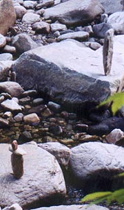 |
| A couple of the numerous gravity-defying cairns in Big
Branch
|
Passing Big Branch shelter we meet the 1st of many thru-hikers this trip – heading southbound on a
flip-flop. Big Branch itself is a rocky creek filled with dozens of cairns – small columns of stones,
many built on as precarious a perch they can be balanced on. A suspension bridge ushers in our gentle
climb into the woods, soon passing the Lost Pond shelter, finding it truly lost, victim of a fire in
2001 (though a couple families out for the weekend are camping here). After a brief chat we forge on
towards our break on the rocky overlook atop Baker Peak, followed by a gradual, but rocky descent that
slows Coleen a bit. A Prairie Home Companion fix entertains me as Coleen listens to her MP3's, and
soon night begins to fall, the headlamps coming out as the path gives way to a lengthy series of
puncheons around Griffith Lake.
Around the tenting area a few tents are illuminated by lights within, and as we ponder our options
here, the caretaker emerges to collect our fare. We find she’s Tortise, having just finished her 16-yr
section hike this August. After paying our $12 and weighing the options (a light drizzle is already
beginning), we opt for the additional half-mile to the Peru Peak shelter, offering a roof over our
heads. It’s a short trek through the night, and the shelter is spacious, clean, and all ours - more
importantly, the heavens burst forth with rain immediately on arrival, which continues throughout the
night and the next morning as well. We can’t help but reflect on our good fortune and timing as we
dine on our sandwiches with hot drinks. We turn in at 10:30, though sleep is slow in coming with the
pounding of the rain and the warm, muggy night air.
9/22 Peru Peak – William Douglas Shelter (15.5 miles)
"Good judgment comes from
experience, and experience comes from bad judgment".
Rita Mae Brown
We wake to a dark rainy morn, but at least we’ve a dry place to pack, a couple hikers
passing by wordlessly as we pack. We're out at 8:08, enjoying the fragrant damp forest as a light rain
drums on the leaves above, shielded enough to walk without rain gear, only our packs covered. After
the fairly level section past Peru Peak and Styles Peak, the trail descends to Mad Tom Notch, by which
time the rain’s largely ended, though the peaks remain shrouded in cloud. The woods are full of
weekend hikers, and our route now climbs to Bromley Mt, a popular skiing area, the final steep climb
finding the summit shrouded in fog. There's a futuristic ski gondola (looking like one of the Star
Trek shuttles) and a cavernous warming hut that's available for overnight stays. It’s a nice hut
(though there’s no water), and a comfortable place out of the dampness for a few minutes to catch up on
our navigation.
| 
|
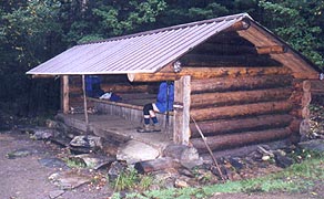
Avoiding the rain at Peru Peak
shelter |
|
After a few minutes here we follow the trail to a
ski slope marked "Easiest Way Down" (a new AT experience - even though it’s a beginner's slope, it’s
surprising how steep it is to walk down). Soon we return to the woods, descending to VT 11, the busy
road from which many hikers hitch into Manchester Center, called a “yuppie Gatlinburg”. We’ve thought
about a town lunch, but prefer to push on for a night in Bennington, so on we go, taking our break at
Spruce Peak shelter. Here we run into a couple guys hiking the LT as a cancer benefit. It’s a great
shelter and we’d love to stay and chat, but we’ve miles to go, so we push on, hoping to stop near the
William B. Douglas shelter, still 3.5 miles distant.
The shelter is ˝ mile off the trail, so we’d hoped to camp nearby, though the guys at Spruce Peak can’t
recall much about sites or water there. The day’s dragging, so we get out the Walkman and MP3 player
to salve ourselves with music, and soon the trail joins the remnants of a gravel road that makes for
easy miles and the rare AT luxury of side-by side walking. It’s a nice end to our long day, though
we’re still left with the choice between tenting by the trail or walking down to the shelter. Showers
are still forecast for tonight (though it's cleared nicely), and though the shelter trail passes a
rushing brook, the only tentsites we find abut the trail, and aren’t nearly level as we’d like. We
choose the shelter, finding the ˝ mile was a gross exaggeration, with the shelter barely half that down
the seriously awash path.
The ancient shelter is found at the corner of a small meadow, barely cut out of the weeds there, and
exceedingly dark inside. Still, we’ve a roof and a small trickling spring adjacent, and Coleen heads
down to the larger brook for a quick cleanup as I toy with starting a fire. Wood is sparse and wet,
but with the alder bark I manage to get one going, although it’s more curse than blessing, as the wind
rises with the clearing skies, swirling through our narrow space to ensure that the smoke’s almost
continuously blown inside. Still, it's a reasonably pleasant evening, with dinner and hot drinks
before retiring at 9:30.
|
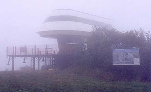
| The Bromley Mt ski lift looms out of the cloud - looks as
though a shuttle from the Enterprise lost their way.
|
|
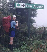
| The small print says, "Easiest Way Down" - both captions
have some truth to them.
|
9/23 Douglas Shelter - Kid Gore Shelter (19.9 miles)
"There is no such thing as a problem without a gift for you in its hands. You seek
problems because you need their gifts".
Richard Bach - Illusions
|
| Today is to be our long day if we’re to make a
town night tomorrow – a plan to which we’re pretty well committed. We’ve discussed tenting halfway to
Bennington, but Coleen’s in favor of pushing out a few more miles to the Kid Gore Shelter, a full 20
miles away. So, when we wake after another stuffy night, I prod Coleen out of our dark and dank perch,
finding that nothing has dried much. We're out once again at 8:08, though at least the trail up to the
AT is no longer a river. It’s another gray, dark day out, a little rain spitting occasionally; and the
legendary Vermont mud rears its head today, with me burying a boot several times. We’re praying for
clearing by the time we climb Stratton Mt – our big climb for the day, and the mountain on which Benton
MacKaye is said to have conceived the idea for the AT with its unbroken trail from Georgia to Maine.
|
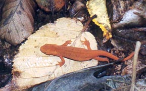
|
| After a rain, the trail's full of these tiny newts
|
It’s a level trail over the rushing Winhall River to the alpine Stratton Pond, where the west wind laps
the waves loudly against the banks as we wind around the shore. Returning to the woods, we take a short
break before the 1500' assault on Stratton Mt. It's a piece of cake compared to the Whites, but it
seems endless with the moderate grade; though the weather clears nicely as we climb. I’m surprised to
find a cold, clear, and surging spring at the summit (and we’d carried lots of water up as the
guidebooks don’t advertise any water here), and suddenly the balsamic firs open to reveal the fire
tower and caretaker hut at the summit. Coleen plops onto a bench here, and I shed my pack for a quick
run up the fire tower, though the frigid west wind drives me back as soon as I get above the treetops.
Caretaker Jean comes over to chat and we find they’ve been doing this every summer for 30 yrs; and that
we’d talked to her husband (Hugh) on our 1998 visit here. We linger a while under the clearing skies
chatting with Jean before our long day impels us onward, finding the slope down rocky and moderately
steep in places. We take a lunch break near the bottom, finding our lunch log in the midst of a
raspberry thicket which proves a great accompaniment to our usual fare.
The afternoon and miles wear on us both, especially Coleen, although she keeps up well, with the
Walkman and MP3 players getting us through the miles. At Story Spring shelter we chat with a couple
hikers - fun guys, but we’ve lots of miles left, and by now we’ll be pushing dark should we continue
to the shelter. Coleen’s iffy about it, but as we pass our last sure water source we feel like pushing
on, stopping only briefly to look for moose (as we do at every marsh). We’re beat, with a couple hours
to go, but Coleen’s accepting of our fate, as there aren’t any better alternatives. It’s an endless
traverse around an unnamed mountain, and the rocks begin in earnest again, compounded by the rapidly
fading light. Soon we don the headlamps, with no sign of the final descent to the shelters, but we
press on and finally it begins - steep and rocky indeed. Darkness and the rocks slow us to a crawl,
and the shelter never seems to come, but finally we reach the bottom.

|
The map shows the shelters partway up the next climb, and we finally reach the old, decrepit
Caughnawaga shelter, said to be a mere 250’ from the much newer Kid Gore shelter. It's a chore to find
which way the AT departs from here (the blazing has gone to hell lately), butfinally we find the trail,
a few minutes later reaching the short side trail to the shelter. It’s rocky and muddy, but as we
arrive (8:30), we see a candle burning on the table, and a hiker still awake in one of the bunks here.
As the guys at Story Spring advised, it's Spanky, a VERY talkative but nice guy, having left his wife
and 8 kids in Miami to do this walk as a benefit for underprivileged kids on Aug 1. Coleen’s not up to
the water search tonight, so I head down to designated spring, finding little more than a mudhole, but
heading back to the AT where I find a pool big enough to scoop up a bagful, and soon supper is served.
We’ve a beautiful view of the moonlit valley below, although there’s a strange diffuse glow at its
bottom (tomorrow we’ll find it to be moonlit fog over the lake in the valley). The wind is rising,
bringing with it colder weather (a welcome relief from the last couple nights), and Spanky turns in
soon after, ourselves finally getting our gear organized on one of the wide bunk platforms, turning in
at 10:30.
| Can anyone identify these berries?
| |
9/24 Kid Gore – Bennington VT (14.4 miles)
"The best portion of a good man's life is his little, nameless, unremembered acts of kindness and of
love."
William Wordsworth
|
It's a beautiful clear morning out, with Spanky getting up and out a few minutes ahead of us. We’re
out at our typical 8:10, finding the trail full of Long Trail hikers, and we exchange the typical info
with them, many of whom Spanky's briefed about ourselves. We take a break at the fire tower atop Mt
Glastenbury, climbing to the top to savor the view, though it’s mostly just a sea of green. As we head
down the back side we pass the spacious and clean Goddard shelter, with a commanding view of Mt
Greylock – a great place to spend the night as we’ll tell the cavalcade of hikers heading that way.
After our lunch break at Porcupine Ridge, I start asking hikers about hotels, and one recommends the
Safford Inn B & B, which sounds a bit more fun than a motel, even if it means a later start. We
descend through Hell Hollow with one final climb over Maple Hill, and then the continuous descent to VT
9 begins, with Coleen’s feet and knee both starting to give her some pain. The poor blazing becomes
apparent as well, as every time we cross a road or other path we end up searching for which juncture to
be correct; with the final descent rocky and steep, as expected.
Finally we pull onto the road, with a parking lot not far away; and we immediately get into our
hitching mode. It works amazingly well, as the 2nd passenger car (a Mercedes, no less) pulls over,
with a nice lady inside. We'll find her the new-agey Veda, from Francestown NH, here to visit some
museums in search of historical information. On finding we’re looking for a B & B, she offers to take
us to the one she’s bound for, which turns out to be the Safford Inn as well – very providential.
Moments later we’re there, welcomed by Sandy, who’s got a room for us as well; explaining the ritual as
we clean off and drag our packs inside. She offers us an early breakfast and suggests a place downtown
for dinner, although our 1st priority is a nice soak in the tub. As night falls we head downtown for
dinner at Carmody’s, a semi-Irish place with a nice menu (all of it high-fat), for a good meal at a
premium price. We settle in to watch tv with a bag of popcorn, retiring in the lap of luxury.
|

|
| The Green Mountains from Glastenbury Fire Tower
|
|
9/25 Bennington – North Adams, MA (18.4 miles)
"Our greatest glory is not in never falling, but in
rising every time we fall."
Confucius
Overnight, we're treated to the intimate details of the upstairs folks'lives, courtesy of the thin
floors (some of which give us broad smiles as we meet them at breakfast). We rise early, starting a pot
of coffee in the room, though a peek outside finds Sandy well under way with breakfast. We start out
with some OJ, followed by delicious blueberry pancakes and sausage, leaving us both sated without even
getting to her further offers of eggs, omelets, English Muffins, or toast. As we’re done, Veda comes
down, immediately offering to take us back to the trailhead – a gesture well appreciated by Sandy as
she’s got a full schedule this morning. As Veda finishes her breakfast we load up the car, and after
settling our $55 bill we head for the trailhead, unloading with our eternal gratitude.
Just as we’re ready to head out, a a section hiker comes running across from the parking lot, seeking a
shuttler in the area (something to do with a partner dropping out on him). I’ve got my little list, so
after satisfying him, we’re on the trail at 8:40, beginning with the steep climb out of the gap. It’s
a bit of a chug, but the trail is well manicured, with stone steps much of the way (though the typical
lack of blazes that causes us to miss one turn, forging up the rockpile to a dead end). Eventually it
levels though, and we’re able to put some speed on towards our car 18 miles distant. Shortly after
leveling off, we reach a meadow with paths weaving through in all directions, none of them blazed.
Although I guess they all intertwine, we get out the map, finding ourselves on Harmon Hill, with a good
view of Bennington before we head off to the south, quickly finding the main channel of the AT.
| 
|
Looking for the trail puncheons at Sucker
Pond |
|
We speed along the level path, with brief stops at Congdon Shelter and Sucker Pond, taking our lunch
break on some large rocks under a powerline that we’ve deemed the halfway point for the day. Some huge
round boulders in the woods barely draw a passing interest as we speed on towards our final stop at the
VT / MA state line. There's a short segment over Eph’s Lookout where the conifers oddly change from
firs to pines, the trail beneath us turning to white sand; but again it scarcely slows us as we drive
towards the finish. Soon the descent starts in earnest, with a steep traverse of a rockslide filled
with huge boulders that even offers a bad-weather abort. It slows Coleen considerably, and even I have
a tough time finding the AT amidst the rocks, but soon we’re clear for the placid descent from here
into town. We join the pastoral Sherman Brook, fronted every few feet by No Camping signs, although
approaching town we begin hearing the voices of kids that quickly go silent as we pass (great party
sites here). The trail spills out through a residential yard onto the street, with a bridge crossing a
railroad yard and the river. Finally, as dark falls, we reach MA Rt 2, from where we left on our MA
section two years ago, and moments later we're back at our car.
It's been a far easier section than we'd imagined, and we're both in good health, also beyond all
expectation. We're both pleased with our progress and Coleen's recovery, so now it's time to really
jump into the deep end - next month, Maine!!
| |


